
Biggest Desert In The World
What is "Desert"?
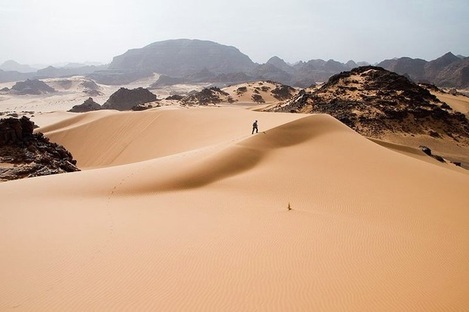
Tadrart Acacus desert in western Libya, part of the Sahara.
A desert biome is an area that receives less than 25cm (about 9.8 inches) of rainfall a year. Deserts are found in the western part of North America, Western Asia, Central Australia, and along the coast of South America.
There are two types of desert hot and cold.There are hot deserts in Africa, such as the Sahara, with scorching hot weather during the day and chilly nights. There are also cold deserts in South America, such as the Atacama, which may have below-freezing temperatures throughout the day and night. Deserts are very dry places. Most of a desert is made up of sand or snow, sand dunes or snowdrifts, and cacti or very small plants. Deserts cover at least 33% of the earth.
Types of Desert
There are hot deserts and cold deserts.
Cold deserts can be found close to the poles. That is why they are also called polar deserts. Other regions of the world have cold deserts too, for instance high altitude areas like the Himalayas. These are called montane deserts. Antarctica is the world's largest cold desert.
There are two types of desert hot and cold.There are hot deserts in Africa, such as the Sahara, with scorching hot weather during the day and chilly nights. There are also cold deserts in South America, such as the Atacama, which may have below-freezing temperatures throughout the day and night. Deserts are very dry places. Most of a desert is made up of sand or snow, sand dunes or snowdrifts, and cacti or very small plants. Deserts cover at least 33% of the earth.
Types of Desert
There are hot deserts and cold deserts.
- Cold deserts
Cold deserts can be found close to the poles. That is why they are also called polar deserts. Other regions of the world have cold deserts too, for instance high altitude areas like the Himalayas. These are called montane deserts. Antarctica is the world's largest cold desert.
- Hot deserts
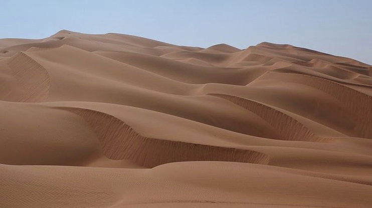
Sand dunes in the Sahara desert
The Sahara
The Sahara (Arabic: الصحراء الكبرى, "The Greatest Desert") is the world's largest hot desert and some time also called world largest desert (See Note end of this topic). At over 9,400,000 square kilometres (3,630,000 sq mi), it covers most of Northern Africa, making it almost as large as Europe or the United States.It is the hottest place on the Earth, but not the driest. The driest is the Atacama Desert in South America.
The Sahara Desert stretches from the Red Sea, including parts of the Mediterranean coasts, to the outskirts of the Atlantic Ocean. To the south, it is delimited by the Sahel: a belt of semi-arid tropical savanna that comprises the northern region of central and western Sub-Saharan Africa.
Some of the sand dunes can reach 180 metres (590 ft) in height.The name comes from the Arabic word for desert: (صَحراء).
The Sahara's boundaries are the Atlantic Ocean on the west, the Atlas Mountains and the Mediterranean Sea on the north, the Red Sea and Egypt on the east, and the Sudan and the valley of the Niger River on the south. The Sahara is divided into western Sahara, the central Ahaggar Mountains, the Tibesti Mountains, the Air Mountains (a region of desert mountains and high plateaus), Ténéré desert and the Libyan desert (the most arid region). The highest peak in the Sahara is Emi Koussi (3,415 m/11,204 ft) in the Tibesti Mountains in northern Chad.
The Sahara divides the continent of Africa into North and Sub-Saharan Africa. The southern border of the Sahara is marked by a band of semiarid savanna called the Sahel; south of the Sahel lies the lusher Sudan and the Congo River Basin. Most of the Sahara consists of rocky hamada; ergs (large sand dunes) form only a minor part.
People lived on the edge of the desert thousands of years ago since the last ice age.The Sahara was then a much wetter place than it is today. Over 30,000 petroglyphs of river animals such as crocodiles survive, with half found in the Tassili n'Ajjer in southeast Algeria. Fossils of dinosaurs, including Afrovenator, Jobaria and Ouranosaurus, have also been found here. The modern Sahara, though, is not lush in vegetation, except in the Nile Valley, at a few oases, and in the northern highlands, where Mediterranean plants such as the olive tree are found to grow. The region has been this way since about 5000 years ago.Inside it are parts of many countries, including Morocco, Algeria, Tunisia, Libya, Egypt, Mauritania, Mali, Niger, Chad, and The Sudan. Some 2.5 million people currently live in the Sahara, most of these in Egypt, Mauritania, Morocco and Algeria. Dominant ethnicities in the Sahara are various Berber groups including Tuareg tribes, various Arabised Berber groups such as the Hassaniya-speaking Maure (Moors, also known as Sahrawis), and various black African ethnicities including Toubou, Nubians, Zaghawa, Kanuri, Peul (Fulani), Hausa and Songhai. Important cities located in the Sahara include Nouakchott (the capital of Mauritania), Tamanrasset, Ouargla, Bechar, Hassi Messaoud, Ghardaia, and El Oued (Algeria), Timbuktu (Mali), Agadez (Niger), Ghat (Libya), as well as Faya-Largeau (Chad).
Sand dunes in the Rub' al Khali part of Arabian Desert
The Arabian Desert
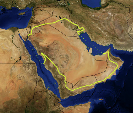
The Arabian Desert (Arabic:صحراء عربية) is a vast desert wilderness stretching from Yemen to the Persian Gulf and Oman to Jordan and Iraq. It occupies most of the Arabian Peninsula with an area of 2,330,000 square kilometers or (900,000 square miles).Arabian Deser is world second largest hot desertAt its center is the Rub'al-Khali, one of the largest continuous bodies of sand in the world.
A large proportion of the Arabian Desert lies with the political borders of Saudi Arabia. However, the Arabian Desert is far too vast to fit within the political confines of a single nation, and spills over into neighboring countries. A significant portion of the desert reaches into Yemen in the southwest and Oman on the eastern border. Along the coast of the Persian Gulf, the Arabian Desert extends into the modern sheikdoms of the United Arab Emirates and Qatar. The desert continues its expansion northward from Saudi Arabia as well, reaching into Emirate of Kuwait and Jordan. Traces of the Arabian Desert are also found in Egypt and Iraq.The vast expanse of the Arabian Desert is formed through a series of natural boundaries that protect the sandy dunes and keep the dusty winds inside the desert. The most prominent borders of the desert are the Gulf of Aden and the Arabian Sea to the southeast and south and the Red Sea in the west.
In addition, the Persian Gulf and the Gulf of Oman lie to the Northeast and east of the desert. The glittering expanses of the sea only serve to highlight the dry nature of the desert and the lack of available water. To the north of the Arabian Desert, the harsh conditions of the desert climate extend up towards the Syrian Desert, making the desert seem especially foreboding.While the surrounding seas play a vital role in defining the borders of the Arabian Peninsula, the desert itself is contained within a ring of mountain ranges. The most notable of the bordering mountain ranges is found in the southwestern corner of the desert belonging to Yemen.
In this area Mount Al-Nabi Shu'ayb towers 12,336 feet above sea level. It has been measured as the highest point in the Arabian Desert, but is closely rivaled by Mount Al-Lawz (elevation 8,464 feet) in the northwest and Mount Al-Sham (elevation 9,957 feet) in the southeast.
Along the northern edges of the Arabian Desert the landscape slowly elevates and blends into the topography of Arab Asia.
The section of land where the desert begins to transform into a more elevated landscape is referred to as the Syrian Steppe, a treeless plain that is noted for its wild beauty. While the northern edges of the Arabian Desert are able to blend seamlessly with the geography of Asia, the southern portions of the desert are much more akin to the land forms found in Somalia and Ethiopia. Some scholars speculate that the dual nature of the Arabian Desert is due to a continental split in its early geological formation that broke the Arabian Peninsula away from Africa.
Like most deserts, the Arabian Desert is classified as a hyper arid climate. Climates of this type are distinguished by extremely low annual rainfall and low humidity. Both of these distinguishing features are clearly seen in the Arabian Desert, which boasts an annual rainfall of under 33mm and less than 15 percent humidity in the summer.While the overall dryness of the Arabian Desert is a formidable obstacle to human occupation, it is actually the extreme daily temperatures that mark the region as uninhabitable on a large scale. In the summer temperatures can reach a scorching 50 degrees Celsius (122 degrees Fahrenheit) in the heat of the day and plummet to extreme cold during the night. In the winter it is not uncommon for night time temperatures to reach below freezing.
The Arabian Desert has been the home to human populations for over 3,000 years. The earliest inhabitants of the region were the Bedouin, a nomadic civilization that used the lands of the Arabian Desert as a breeding ground for camels. While using the natural growth in the region to support their herd, the Bedouin also began a system of standardized agriculture in the desert.
The discovery of petroleum in the region in 1936 ushered in a flood of Western cultural influence that severely threatened the traditional lives of the Bedouin. Perhaps the most significant change in the region following the discovery of petroleum was the increase in transportation options in the area. Now that trucks are widely used as a method of transportation, more Bedouin children have access to an education and other social services.
While the Arabian Desert appears inhospitable and barren at first glance, it has proven to be a valuable source for natural resources, including oil, natural gas, phosphates, and sulfur. The Arabian Desert also covers a vast reserve of underground groundwater that has been trapped beneath the sands since the Pleistocene Age. In recent years the underground reserve has been tapped and used for irrigation in the region. The groundwater, coupled with water reclaimed through desalinization, has allowed the Arabian Peninsula to be far more hospitable to modern populations than those of the past. Oil reserves have also been tapped in recent years; however, exportation of petroleum products from the region is often interrupted by international crises like the Persian Gulf War.
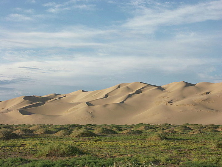
Khongoryn Els sand dunes in the Gobi Desert
The Gobi
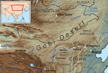
The Gobi (Mongolian: Говь, Govi, "semidesert"; Chinese: 戈壁沙漠 Gēbì Shāmò Urdu: صحرائے گوبی) is a large desert region in Asia. It covers parts of northern and northwestern China, and of southern Mongolia. The desert basins of the Gobi are bounded by the Altai Mountains and the grasslands and steppes of Mongolia on the north, by the Hexi Corridor and Tibetan Plateau to the southwest, and by the North China Plain to the southeast. The Gobi is made up of several distinct ecological and geographic regions based on variations in climate and topography. This desert is the 3th largest hot desert in the world and fifth largest desert in world including cold desert.
The Gobi is most notable in history as part of the great Mongol Empire, and as the location of several important cities along the Silk Road.The Gobi is a rain shadow desert formed by the Himalaya range blocking rain-carrying clouds from reaching the Gobi.
The Gobi measures over 1,610 km (1,000 mi) from southwest to northeast and 800 km (497 mi) from north to south. The desert is widest in the west, along the line joining the Lake Bosten and the Lop Nor (87°-89° east). It occupies an arc of land 1,295,000 km2 (500,002 sq mi) in area, making it fifth largest in the world and Asia's largest. Much of the Gobi is not sandy but is covered with bare rock.
The Gobi has several different Chinese names, including 沙漠 (Shāmò, actually a generic term for deserts in general) and 瀚海 (Hànhǎi, "endless sea"). In its broadest definition, the Gobi includes the long stretch of desert and semi-desert area extending from the foot of the Pamirs, 77° east, to the Greater Khingan Mountains, 116°-118° east, on the border of Manchuria; and from the foothills of the Altay, Sayan, and Yablonoi mountain ranges on the north to the Kunlun, Altyn-Tagh, and Qilian mountain ranges, which form the northern edges of the Tibetan Plateau, on the south.
A relatively large area on the east side of the Greater Khingan range, between the upper waters of the Songhua (Sungari) and the upper waters of the Liao-ho, is also reckoned to belong to the Gobi by conventional usage. On the other hand, geographers and ecologists prefer to regard the western area of the Gobi region (as defined above), the basin of the Tarim in Xinjiang and the desert basin of Lop Nor and Hami (Kumul) as forming a separate and independent desert, called the Taklamakan Desert.
The Nemegt Basin in the northwestern part of the Gobi Desert (in Mongolia) is famous for its fossil treasures, including early mammals, dinosaur eggs, and even prehistoric stone implements, some 100,000 years old.
The Gobi is a cold desert, and it is not uncommon to see frost and occasionally snow on its dunes. Besides being quite far north, it is also located on a plateau roughly 910–1,520 meters (3,000–5,000 ft) above sea level, which further contributes to its low temperatures. An average of approximately 194 millimeters (7.6 in) of rain falls per year in the Gobi. Additional moisture reaches parts of the Gobi in winter as snow is blown by the wind from the SiberianSteppes. These winds cause the Gobi to reach extremes of temperature ranging from –40°C (-40°F) in winter to +50°C (122°F) in summer.
Notes
Antarctica is considered a desert, with annual precipitation of only 200 mm (8 inches) along the coast and far less inland.If it is realy a desert then it is biggest desert in the world by the area of 13,829,430 square kilometres.
As well as Arctic is considered a desert due to low level of precipitation.If it is realy a desert then it is second biggest desert in the world by the area of 13,700,000 square kilometres.
As well as Arctic is considered a desert due to low level of precipitation.If it is realy a desert then it is second biggest desert in the world by the area of 13,700,000 square kilometres.
