
Longest River By Continent
What thing is called "River"?
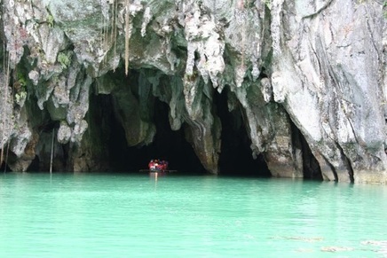
The entrance of Puerto Princesa Underground River in Palawan, Philippines.
A river is a stream of water that flows through a "channel" (or passage) in the surface of the ground. The passage where the river flows is called the riverbed and the earth on each side is called a riverbank. A river begins on high ground or in hills or mountains and flows down from the high ground to the lower ground, because of gravity. A river begins as a small stream and gets bigger, the farther that it flows.
The water in a river is called "fresh water". It comes from rain or snow and it can usually be drunk safely, unless it has been polluted. The water in a sea cannot be drunk safely because it is "salt water". Both people and animals often live near rivers, because they need water to survive.
The water in a river is called "fresh water". It comes from rain or snow and it can usually be drunk safely, unless it has been polluted. The water in a sea cannot be drunk safely because it is "salt water". Both people and animals often live near rivers, because they need water to survive.
Longest River By Continent
|
|
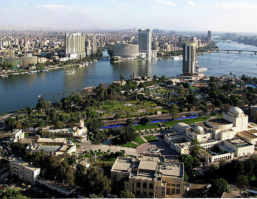
The Nile passes through Cairo, Egypt's capital city
The Nile
The Nile (Arabic: النيل an-nil, Ancient Egyptian iteru or Ḥ'pī, Coptic piaro or phiaro) is a major north-flowing river in Africa.It is the longest river on Earth also longest river in Africa (about 6,650 km or 4,132 miles), and flows into the Mediterranean Sea near Alexandria.
The word "Nile" comes from Greek Neilos (Νεῖλος), of unknown derivation. In the ancient Egyptian language, the Nile is called Ḥ'pī or iteru, meaning "great river", represented by the hieroglyphs shown on the right (literally itrw, and 'waters' determinative).In Coptic, the words piaro (Sahidic) or phiaro (Bohairic) meaning "the river" (lit. p(h).iar-o "the.canal-great") come from the same ancient name.
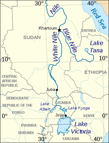
The Nile has two major tributaries, the White Nile and Blue Nile, the latter being the source of most of the Nile's water and fertile soil, but the former being the longer of the two. The White Nile rises in the Great Lakes region of central Africa, with the most distant source in southern Rwanda and flows north from there through Tanzania, Lake Victoria, Uganda and southern Sudan, while the Blue Nile starts at Lake Tana in Ethiopia,flowing into Sudan from the southeast. The two rivers meet near the Sudanese capital of Khartoum.
The northern section of the river flows almost entirely through desert, from Sudan into Egypt, a country whose civilization has depended on the river since ancient times. Most of the population and cities of Egypt lie along those parts of the Nile valley north of Aswan, and nearly all the cultural and historical sites of Ancient Egypt are found along the banks of the river. The Nile ends in a large delta that empties into the Mediterranean Sea.
There are many different types of animals living in or near the waters of the Nile, including crocodiles, birds, fish and many others. Not only do animals depend on the Nile for survival, but also people who live there need it for everyday use like washing, as a water supply, keeping crops watered and other jobs.
The word "Nile" comes from Greek Neilos (Νεῖλος), of unknown derivation. In the ancient Egyptian language, the Nile is called Ḥ'pī or iteru, meaning "great river", represented by the hieroglyphs shown on the right (literally itrw, and 'waters' determinative).In Coptic, the words piaro (Sahidic) or phiaro (Bohairic) meaning "the river" (lit. p(h).iar-o "the.canal-great") come from the same ancient name.
The Nile has two major tributaries, the White Nile and Blue Nile, the latter being the source of most of the Nile's water and fertile soil, but the former being the longer of the two. The White Nile rises in the Great Lakes region of central Africa, with the most distant source in southern Rwanda and flows north from there through Tanzania, Lake Victoria, Uganda and southern Sudan, while the Blue Nile starts at Lake Tana in Ethiopia,flowing into Sudan from the southeast. The two rivers meet near the Sudanese capital of Khartoum.
The northern section of the river flows almost entirely through desert, from Sudan into Egypt, a country whose civilization has depended on the river since ancient times. Most of the population and cities of Egypt lie along those parts of the Nile valley north of Aswan, and nearly all the cultural and historical sites of Ancient Egypt are found along the banks of the river. The Nile ends in a large delta that empties into the Mediterranean Sea.
There are many different types of animals living in or near the waters of the Nile, including crocodiles, birds, fish and many others. Not only do animals depend on the Nile for survival, but also people who live there need it for everyday use like washing, as a water supply, keeping crops watered and other jobs.
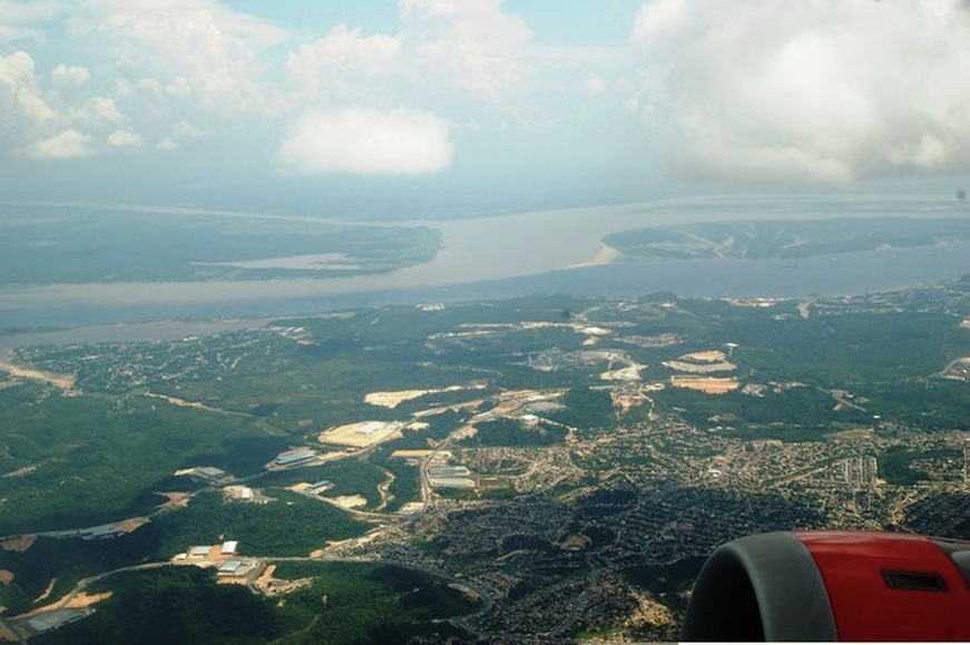
Amazon River Near Brazil
The Amazon River
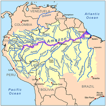
The Amazon River (US) or River Amazon (UK) (Portuguese: Rio Amazonas; Spanish: Río Amazonas) of South America is the largest river in the world with a total discharge greater than the next ten largest rivers combined. The Amazon, which has the largest drainage basin in the world, about 7,050,000 square kilometres (2,720,000 sq mi), accounts for approximately one-fifth of the world's total river flow.It total length is 6,400 km.It is also a longest river in South America and second longest river in world after nile..
The Amazon river has a series of major river systems in Peru and Ecuador, some of which flow into the Marañón and Ucayali, others directly into the Amazon proper. Among others, these include the following rivers: Morona, Pastaza, Nucuray, Urituyacu, Chambira, Tigre, Nanay, Napo, and Huallaga.
The most distant source of the Amazon was established in 1996, 2001,2007,and 2008, as a glacial stream on a snowcapped 5,597 m (18,363 ft) peak called Nevado Mismi in the Peruvian Andes, roughly 160 km (99 mi) west of Lake Titicaca and 700 km (430 mi) southeast of Lima. The waters from Nevado Mismi flow into the Quebradas Carhuasanta and Apacheta, which flow into the Río Apurímac which is a tributary of the Ucayali which later joins the Marañón to form the Amazon proper. While the Ucayali–Marañón confluence is the point at which most geographers place the beginning of the Amazon proper, in Brazil the river is known at this point as the Solimões das Águas. Shortly downriver from that confluence the darkly colored waters of the Rio Negro meet the sandy colored Rio Solimões, and for over 6 km (4 mi) these waters run side by side without mixing.
After the confluence of Río Apurímac and Ucayali, the river leaves Andean terrain and is instead surrounded by floodplain. From this point to`the Marañón, some 1,600 km (990 mi), the forested banks are just out of water, and are inundated long before the river attains its maximum flood stage. The low river banks are interrupted by only a few hills, and the river enters the enormous Amazon Rainforest.
The river systems and flood plains in Brazil, Peru, Ecuador, Colombia and Venezuela, whose waters drain into the Solimões and its tributaries are called the "Upper Amazon". The Amazon River proper runs mostly through Brazil and Peru, and it has tributaries reaching into Venezuela, Colombia, Ecuador, and Bolivia.
In its upper stretches the Amazon river is called Apurímac (In Peru) and Solimões (In Brazil). The width of the Amazon varies between 1.6 and 10 kilometres (0.99 and 6.2 mi) at low stage, but expands during the wet season to 48 kilometres (30 mi) or more. The river enters the Atlantic Ocean in a broad estuary about 240 kilometres (150 mi) wide. The mouth of the main stem is 80 kilometres (50 mi).Because of its vast dimensions, it is sometimes called The River Sea. At no point is the Amazon crossed by bridges.This is not because of its huge dimensions; in fact, for most of its length, the Amazon's width is well within the capability of modern engineers to bridge. However, the bulk of the river flows through tropical rainforest, where there are few roads and even fewer cities, so there is no need for crossings.
While the Amazon is the largest river in the world by most measures, the current consensus within the geographic community holds that the Amazon is the second longest river, just slightly shorter than the Nile.
The Yangtze River
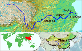
The Yangtze River, or Chang Jiang (simplified Chinese: 长江; traditional Chinese: 長江; pinyin: Cháng Jiang; literally "The Long River"; Tibetan: 'Bri-chu), is the longest river in Asia, and the third-longest in the world.
Like many rivers, the river is known by different names over its course. At its source, it is called in Chinese the Dangqu (当曲, from the Tibetan for "marsh river"). Downstream, it is called the Tuotuo River (沱沱河) and then the Tongtian River (通天河, literally "river passing through heaven"). Where it runs through deep gorges parallel to the Mekong and the Salween before emerging onto the plains of Sichuan, it is known as the Jinsha River (金沙江 Jīnshā Jiāng, literally "golden sands river").
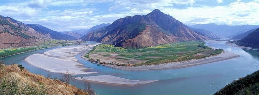
The river is about 6,300 kilometres (3,915 mi) long and flows from its source in Qinghai Province, eastwards into the East China Sea at Shanghai. It acts as a dividing line between North and South China, although geographers generally consider the Qinling-Huai River line to be the official line of geographical division.As the largest river in the region, the Yangtze is historically, culturally, and economically important to China. The section of the river flowing through deep gorges in Yunnan province is part of the Three Parallel Rivers of Yunnan Protected Areas: a UNESCO World Heritage Site.
The river originates in a glacier lying on the west of Geladandong Mountain in the Dangla Mountain Range on the eastern part of the Tibetan plateau. It runs eastward through Qinghai, turning southward down a deep valley at the border of Sichuan and Tibet to reach Yunnan. In the course of this valley, the river's elevation drops from above 5000 m to less than 1000 m. The headwaters of the Yangtze are situated at an elevation of about 4,900 m (16,100 ft). In its descent to sea level, the river falls to an altitude of 305 m (1,001 ft) at Yibin, Sichuan Province, the head of navigation for riverboats, and to 192 m (630 ft) at Chongqing. Between Chongqing and Yichang (I-ch'ang), at an altitude of 40 m (130 ft) and a distance of about 320 km (200 mi), it passes through the spectacular Yangtze Gorges, which are noted for their natural beauty but are dangerous to shipping.
It enters the basin of Sichuan at Yibin. While in the Sichuan basin, it receives several mighty tributaries, increasing its water volume significantly. It then cuts through Mount Wushan bordering Chongqing and Hubei to create the famous Three Gorges. Eastward of the Three Gorges, Yichang is the first city on the Yangtze Plain.
After entering Hubei, the Yangtze receives more water from thousands of lakes. The largest of these lakes is Dongting Lake, which is located on the border of Hunan and Hubei provinces, and is the outlet for most of the rivers in Hunan. At Wuhan, it receives its biggest tributary, the Han River, bringing water from its northern basin as far as Shaanxi.
At the northern tip of Jiangxi, Lake Poyang, the biggest freshwater lake in China, merges into the river. The river then runs through Anhui and Jiangsu provinces, receiving more water from innumerable smaller lakes and rivers, and finally reaches the East China Sea at Shanghai.
Four of China's five main freshwater lakes contribute their waters to the Yangtze River. Traditionally, the upstream part of the Yangtze River refers to the section from Yibin to Yichang; the middle part refers to the section from Yichang to Hukou County, where Lake Poyang meets the river; the downstream part is from Hukou to Shanghai. It is home to many thousands of people.
Like many rivers, the river is known by different names over its course. At its source, it is called in Chinese the Dangqu (当曲, from the Tibetan for "marsh river"). Downstream, it is called the Tuotuo River (沱沱河) and then the Tongtian River (通天河, literally "river passing through heaven"). Where it runs through deep gorges parallel to the Mekong and the Salween before emerging onto the plains of Sichuan, it is known as the Jinsha River (金沙江 Jīnshā Jiāng, literally "golden sands river").
The river is about 6,300 kilometres (3,915 mi) long and flows from its source in Qinghai Province, eastwards into the East China Sea at Shanghai. It acts as a dividing line between North and South China, although geographers generally consider the Qinling-Huai River line to be the official line of geographical division.As the largest river in the region, the Yangtze is historically, culturally, and economically important to China. The section of the river flowing through deep gorges in Yunnan province is part of the Three Parallel Rivers of Yunnan Protected Areas: a UNESCO World Heritage Site.
The river originates in a glacier lying on the west of Geladandong Mountain in the Dangla Mountain Range on the eastern part of the Tibetan plateau. It runs eastward through Qinghai, turning southward down a deep valley at the border of Sichuan and Tibet to reach Yunnan. In the course of this valley, the river's elevation drops from above 5000 m to less than 1000 m. The headwaters of the Yangtze are situated at an elevation of about 4,900 m (16,100 ft). In its descent to sea level, the river falls to an altitude of 305 m (1,001 ft) at Yibin, Sichuan Province, the head of navigation for riverboats, and to 192 m (630 ft) at Chongqing. Between Chongqing and Yichang (I-ch'ang), at an altitude of 40 m (130 ft) and a distance of about 320 km (200 mi), it passes through the spectacular Yangtze Gorges, which are noted for their natural beauty but are dangerous to shipping.
It enters the basin of Sichuan at Yibin. While in the Sichuan basin, it receives several mighty tributaries, increasing its water volume significantly. It then cuts through Mount Wushan bordering Chongqing and Hubei to create the famous Three Gorges. Eastward of the Three Gorges, Yichang is the first city on the Yangtze Plain.
After entering Hubei, the Yangtze receives more water from thousands of lakes. The largest of these lakes is Dongting Lake, which is located on the border of Hunan and Hubei provinces, and is the outlet for most of the rivers in Hunan. At Wuhan, it receives its biggest tributary, the Han River, bringing water from its northern basin as far as Shaanxi.
At the northern tip of Jiangxi, Lake Poyang, the biggest freshwater lake in China, merges into the river. The river then runs through Anhui and Jiangsu provinces, receiving more water from innumerable smaller lakes and rivers, and finally reaches the East China Sea at Shanghai.
Four of China's five main freshwater lakes contribute their waters to the Yangtze River. Traditionally, the upstream part of the Yangtze River refers to the section from Yibin to Yichang; the middle part refers to the section from Yichang to Hukou County, where Lake Poyang meets the river; the downstream part is from Hukou to Shanghai. It is home to many thousands of people.
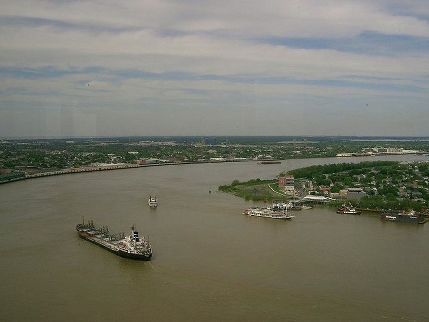
Lower course of the Mississippi through New Orleans
The Mississippi River
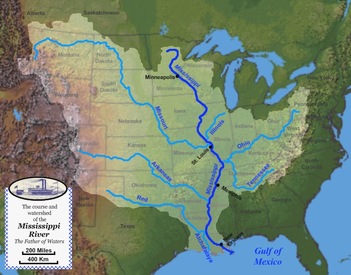
The Mississippi River is the largest river system in North America.About 2,320 miles (3,730 km) long,the river originates at Lake Itasca, Minnesota and flows slowly southwards in sweeping meanders, terminating 95 river miles below New Orleans, Louisiana where it begins to flow to the Gulf of Mexico. Along with its major tributary, the Missouri River, the river drains all or parts of 31 U.S. states stretching from the Rocky Mountains in the west to the Appalachian Mountains in the east to the Canada-U.S. border on the north, including most of the Great Plains, and is the fourth longest river in the world and the tenth most powerful river in the world.The name "Mississippi" comes from a Native American name that means "big river."
The source of the Mississippi is in the state of Minnesota, near the border with Canada. The Mississippi flows south through the middle of the United States. It flows past the states of Wisconsin, Iowa, Illinois, Missouri, Kentucky, Tennessee, Arkansas, and Mississippi.The Mississippi has many large tributaries, or rivers that flow into it. The watershed of the Mississippi covers much of the United States. This means that the Mississippi and its tributaries drain much of the United States. Some important tributaries of the Mississippi are (listed from the source to the mouth of the river)
The source of the Mississippi is in the state of Minnesota, near the border with Canada. The Mississippi flows south through the middle of the United States. It flows past the states of Wisconsin, Iowa, Illinois, Missouri, Kentucky, Tennessee, Arkansas, and Mississippi.The Mississippi has many large tributaries, or rivers that flow into it. The watershed of the Mississippi covers much of the United States. This means that the Mississippi and its tributaries drain much of the United States. Some important tributaries of the Mississippi are (listed from the source to the mouth of the river)
- The Minnesota River
- The St. Croix River
- The Wisconsin River
- The Illinois River
- The Missouri River
- The Ohio River
- The Arkansas River
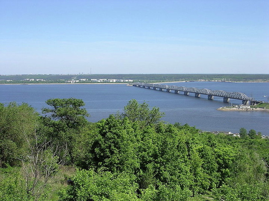
The Volga
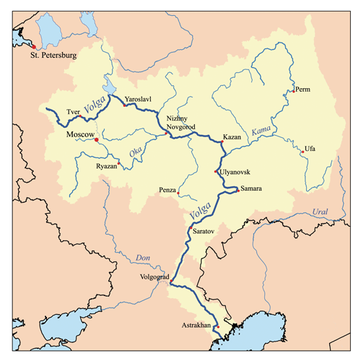
The Volga (Russian: Волга) is the largest river in Europe in terms of length, discharge, and watershed. It flows through central Russia, and is widely viewed as the national river of Russia. Out of the twenty largest cities of Russia, eleven, including its capital Moscow, are situated in the Volga's drainage basin.The Russian hydronym "Волга" is akin to the old Mari name of the river - Volgydo that means "bright".
Many people see it as the national river of Russia. It flows through the western part of the country. It is Europe's longest river, with a length of 3,690 kilometres (2,293 miles), and forms the core of the largest river system in Europe. It rises in the Valdai Hills of Russia, 225m above sea level north-west of Moscow. The Kama, Oka, Vetluga and the Sura are its main tributaries. The Volga and its tributaries form the Volga river system, which drains an area of about 1.35 million square kilometres in Russia. The Volga Delta has a length of about 160 kilometres. It includes 555 channels and small streams. It is the largest estuary in Europe. It is the only place in Russia where pelicans, flamingoes, and lotuses may be found. The Volga freezes for most of its length for three months each year. Some of the biggest reservoirs in the world can be found along the river.
Many people see it as the national river of Russia. It flows through the western part of the country. It is Europe's longest river, with a length of 3,690 kilometres (2,293 miles), and forms the core of the largest river system in Europe. It rises in the Valdai Hills of Russia, 225m above sea level north-west of Moscow. The Kama, Oka, Vetluga and the Sura are its main tributaries. The Volga and its tributaries form the Volga river system, which drains an area of about 1.35 million square kilometres in Russia. The Volga Delta has a length of about 160 kilometres. It includes 555 channels and small streams. It is the largest estuary in Europe. It is the only place in Russia where pelicans, flamingoes, and lotuses may be found. The Volga freezes for most of its length for three months each year. Some of the biggest reservoirs in the world can be found along the river.
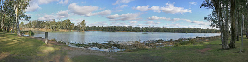
The confluence of the Darling and Murray Rivers at Wentworth, New South Wales
The Murray River
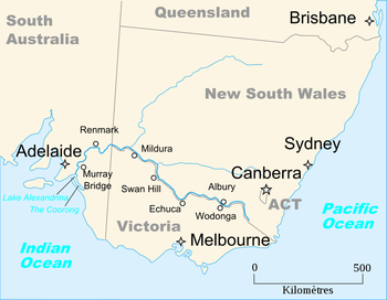
The Murray River is Australia's longest river. At 2,375 kilometres (1,476 mi) in length.
It starts high in the Snowy Mountains and flows mainly west until it gets to the sea near Goolwa, South Australia. For much of its length it forms the boundary between Victoria and New South Wales. Other rivers join the Murray, the Darling River, the Lachlan River, the Murrumbidgee River and the Goulburn River.Murray River falls in Indian Ocean. The river was first called the Hume River after it was discovered by European explorers Hamilton Hume and William Hovell in November 1824. Explorer Charles Sturt renamed the river in January 1830 after a British politician, Sir George Murray.
It starts high in the Snowy Mountains and flows mainly west until it gets to the sea near Goolwa, South Australia. For much of its length it forms the boundary between Victoria and New South Wales. Other rivers join the Murray, the Darling River, the Lachlan River, the Murrumbidgee River and the Goulburn River.Murray River falls in Indian Ocean. The river was first called the Hume River after it was discovered by European explorers Hamilton Hume and William Hovell in November 1824. Explorer Charles Sturt renamed the river in January 1830 after a British politician, Sir George Murray.
