
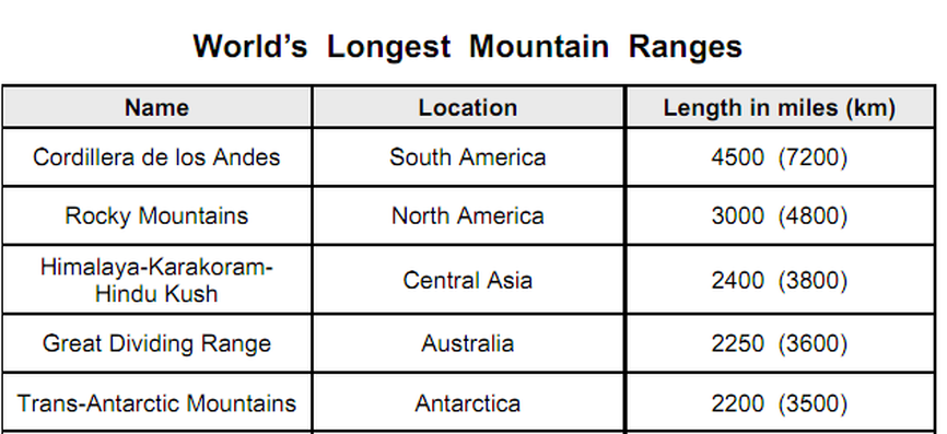
Longest Mountain Ranges In World
What Is Meant By Mountain Range?
A mountain range is a single, large mass consisting of a succession of mountains or narrowly spaced mountain ridges, with or without peaks, closely related in position, direction, formation, and age; a component part of a mountain system or of a mountain chain.
Other definitions may include a mountain system which is a group of mountain ranges exhibiting certain unifying features, such as similarity in form, structure, and alignment, and presumably originating from the same general causes; esp. a series of ranges belonging to an orogenic belt. A mountain system or system of mountain ranges sometimes is used to combine several geological features that are geographically (regionally) related.
Mountain range is divided by highlands or mountain passes and valleys. Individual mountains within the same mountain range do not necessarily have the same geology, though they often do; they may be a mix of different orogeny, for example volcanoes, uplifted mountains or fold mountains and may, therefore, be of different rock.
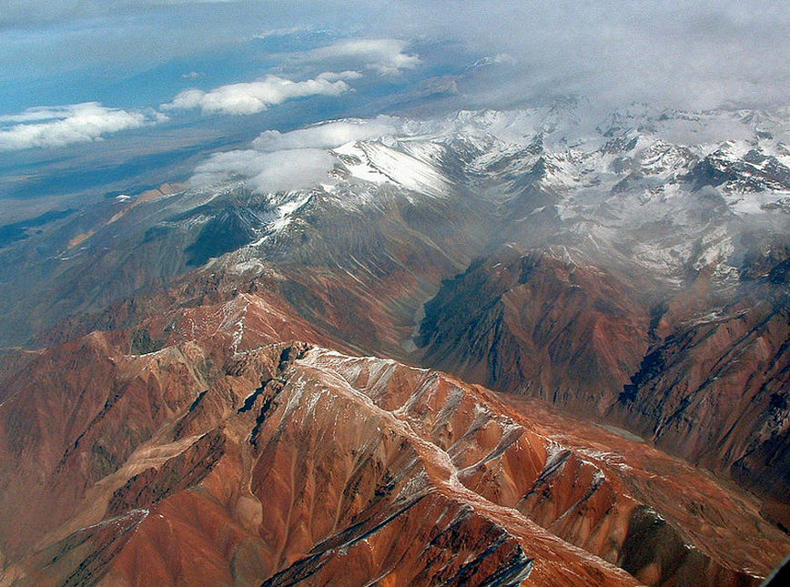
Central Andes
Andes - Longest Mountain Range
The Andes are the world's longest continental mountain range. It is a continual range of highlands along the western coast of South America. This range is about 7200 km (4,500 mi) long, about 200 km (120 mi) to 700 km (430 mi) wide (widest between 18 degrees South and 20 degrees South latitude), and of an average height of about 4,000 m (13,000 ft).
The etymology of the word Andes has been debated. The major consensus is that it derives from the Quechua word anti, which means "high crest". Others believe that Andes comes from Anti Suyu, one of the four regions of the Inca empire. It is more likely however that the word Antisuyo derives from the use of Anti to designate mountain chains. Derivation from the Spanish andén (in the sense of cultivation terrace) has also been proposed, yet considered very unlikely.
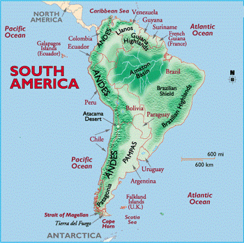
Along their length, the Andes are split into several ranges, which are separated by intermediate depressions. The Andes are the location of several high plateaus some of which host major cities such as Quito, Bogotá, Arequipa, Medellín, Sucre, and La Paz.
The socalled Altiplano plateau is the world's second-highest plateau following the Tibetan plateau. The Andes extend to seven countries, in alphabetical order: Argentina, Bolivia, Chile, Colombia, Ecuador, Peru, and Venezuela, some of which are known as the Andean States.
The Andes range is the world's highest mountain range outside of the continent of Asia. Their highest peak, Mt. Aconcagua, rises to an elevation of about 6,962 m (22,841 ft) above sea level. The peak of Mt. Chimborazo in the Ecuadorean Andes is located at the point on the surface of the Earth that is the most distant one from its center. This is because of the Earth's equatorial bulge that results from its rapid rotation (far faster than those of Venus, Mercury, the Moon, Ganymede, Titan, or Triton). The world's highest volcanos are in the Andes, including Ojos del Salado on the Chile-Argentina frontier which rises to 6,893 m (22,615 ft), and over 50 other volcanos that rise above 6,000 m.
The Andes can be divided into three sections:
The etymology of the word Andes has been debated. The major consensus is that it derives from the Quechua word anti, which means "high crest". Others believe that Andes comes from Anti Suyu, one of the four regions of the Inca empire. It is more likely however that the word Antisuyo derives from the use of Anti to designate mountain chains. Derivation from the Spanish andén (in the sense of cultivation terrace) has also been proposed, yet considered very unlikely.
Along their length, the Andes are split into several ranges, which are separated by intermediate depressions. The Andes are the location of several high plateaus some of which host major cities such as Quito, Bogotá, Arequipa, Medellín, Sucre, and La Paz.
The socalled Altiplano plateau is the world's second-highest plateau following the Tibetan plateau. The Andes extend to seven countries, in alphabetical order: Argentina, Bolivia, Chile, Colombia, Ecuador, Peru, and Venezuela, some of which are known as the Andean States.
The Andes range is the world's highest mountain range outside of the continent of Asia. Their highest peak, Mt. Aconcagua, rises to an elevation of about 6,962 m (22,841 ft) above sea level. The peak of Mt. Chimborazo in the Ecuadorean Andes is located at the point on the surface of the Earth that is the most distant one from its center. This is because of the Earth's equatorial bulge that results from its rapid rotation (far faster than those of Venus, Mercury, the Moon, Ganymede, Titan, or Triton). The world's highest volcanos are in the Andes, including Ojos del Salado on the Chile-Argentina frontier which rises to 6,893 m (22,615 ft), and over 50 other volcanos that rise above 6,000 m.
The Andes can be divided into three sections:
- The Southern Andes in Argentina and Chile.
- The Central Andes, including the Chilean and Peruvian cordilleras and parts of Bolivia.
- The Northern Andes in Venezuela, Colombia, and Ecuador that consist of two parallel ranges, the Cordillera Occidental and the Cordillera Oriental. In Colombia, north its the border with Ecuador, the Andes split in three parallel ranges, the western, central, and eastern ranges. (The cordillera occidental, central, and oriental).
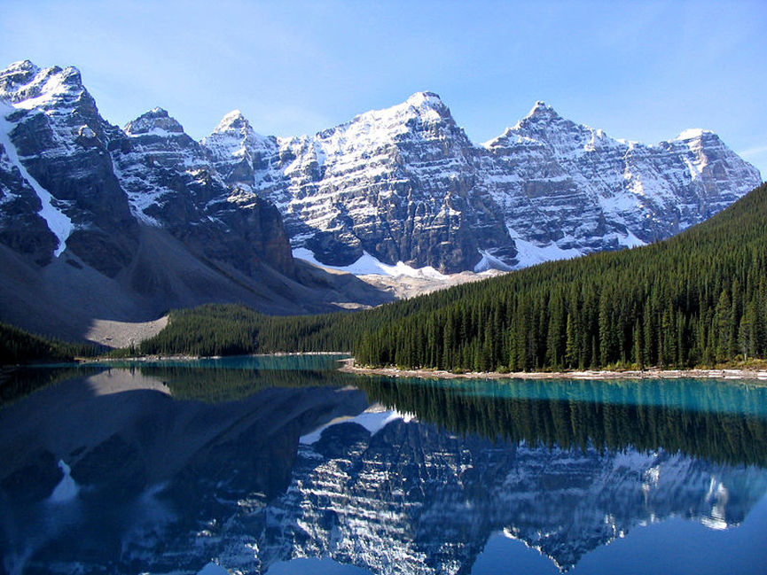
Moraine Lake, and the Valley of the Ten Peaks, Banff National Park, Alberta, Canada
Rocky Mountains
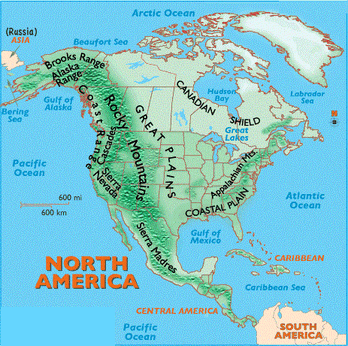
The Rocky Mountains (or Rockies) are a major mountain range in western North America. The Rocky Mountains stretch more than 3,000 miles (4,800 km) from the northernmost part of British Columbia, in western Canada, to New Mexico, in the southwestern United States. The range's highest peak is Mount Elbert located in Colorado at 14,440 feet (4,401 m) above sea level. Though part of North America's Pacific Cordillera, the Rockies are distinct from the Pacific Coast Ranges (as named in Canada) or the Coast Range (as it is known in the United States) which are located directly adjacent to the Pacific coast, as well as, the Cascade Range and Sierra Nevada which lie further inland from the coast.
The Rockies were formed from 80 to 55 million years ago by the Laramide orogeny. Since then, erosion by water and glaciers have sculpted the mountain range into dramatic valleys and peaks. At the end of the last ice age, humans started to inhabit the mountain range. After Europeans, such as Sir Alexander MacKenzie and the Lewis and Clark expedition, started to explore the range, minerals and furs drove the initial economic exploitation of the mountains, although the range never became densely populated.
Currently, much of the mountain range is protected by public parks and forest lands, and is a popular tourist destination, especially for hiking, camping, mountaineering, fishing, hunting, skiing, and snowboarding.
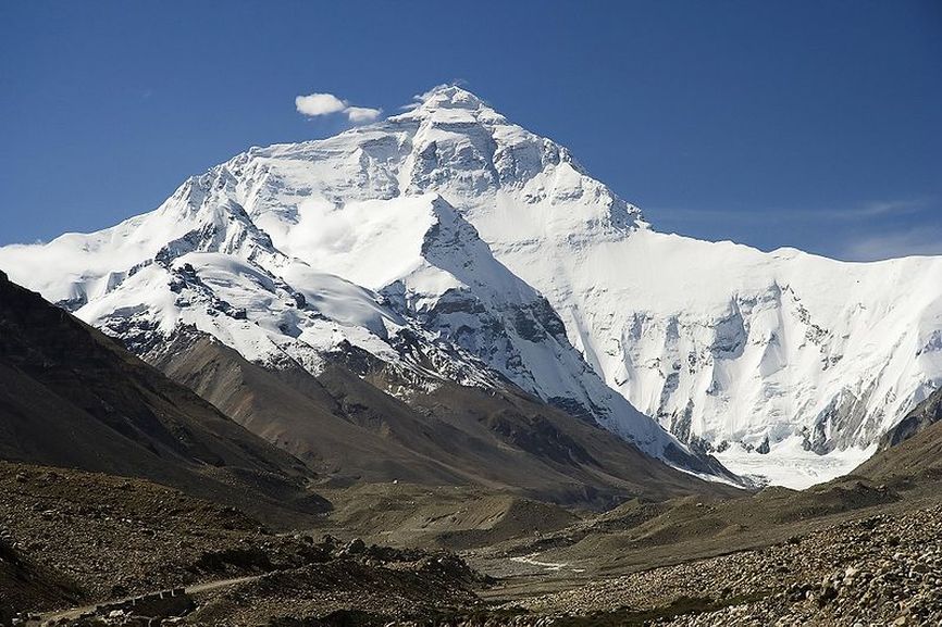
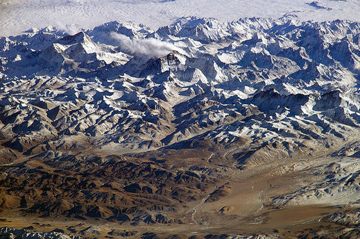
The north face of Mount Everest
Himalaya - Highest Mountain Range
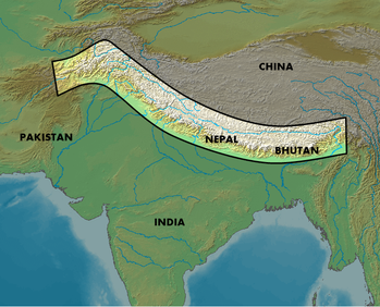
The Himalaya Range or Himalaya Mountains (Sanskrit: literally, "abode of snow") usually called the Himalayas or Himalaya for short, is a mountain range in Asia, separating the Indian subcontinent from the Tibetan Plateau. By extension, it is also the name of a massive mountain system that includes the Karakoram, the Hindu Kush, and other, lesser, ranges that extend out from the Pamir Knot.
Together, the Himalayan mountain system is the planet's highest, and home to the world's highest peaks, the Eight-thousanders, which include Mount Everest and K2. To comprehend the enormous scale of this mountain range, consider that Aconcagua, in the Andes, at 6,962 metres (22,841 ft) is the highest peak outside Asia, whereas the Himalayan system includes over 100 mountains exceeding 7,200 m (23,622 ft).
Some of the world's major rivers, the Ganges, Indus, Brahmaputra, Yangtze, Mekong, Salween, Red River (Asia), Xunjiang, Chao Phraya, Irrawaddy River, Amu Darya, Syr Darya, Tarim River and Yellow River, rise in the Himalayas, and their combined drainage basin is home to some 3 billion people (almost half of Earth's population) in Afghanistan, Bangladesh, Bhutan, People's Republic of China, India, Nepal, Burma, Cambodia, Tajikistan, Uzbekistan, Turkmenistan, Kazakhstan, Kyrgyzstan, Thailand, Laos, Vietnam, Malaysia and Pakistan.
The Himalayas have profoundly shaped the cultures of South Asia; many Himalayan peaks are sacred in Hinduism, Buddhism and Sikhism. The main Himalaya range runs west to east, from the Indus river valley to the Brahmaputra river valley, forming an arc 2,400 km (1,491 mi) long, which varies in width from 400 km (249 mi) in the western Kashmir-Xinjiang region to 150 km (93 mi) in the eastern Tibet-Arunachal Pradesh region. The range consists of three coextensive sub-ranges (Great,Middle, with the northernmost, and highest, known as the Great or Inner Himalayas.
Physically, the Himalayas forms three parallel zones: the Great Himalayas, the Middle Himalayas (also known as the Inner or Lesser Himalayas), and the Sub-Himalayas, which includes the Siwālik Range and foothills and the Tarāi and Duars piedmont (an area of land formed or lying at the foot of a mountain or mountain range).The Great Himalayas, the highest zone, consists of a huge line of snowy peaks with an average height exceeding 6,100 m (20,000 ft). The width of this zone, composed largely but not entirely of gneiss and granite, is about 24 km (about 15 mi). Spurs from the Great Himalayas project southwards into the Middle Himalayas in an irregular fashion. The Nepal and Sikkim (a state of northern India) portion of the Great Himalayas contains the greatest number of high peaks. The snow line on the southern slopes of the Great Himalayas varies from 4,480 m (14,700 ft) in the eastern and central Himalayas of Nepal and Sikkim to 5,180 m (17,000 ft) in the western Himalayas. To the north of the Great Himalayas are several ranges such as the Zāskār, Ladakh, and the Kailas. The Karakoram Range lies on the Tibetan side of the Great Himalayas.
The Middle Himalayas range, which has a width of about 80 km (about 50 mi), borders the Great Himalayan range on the south. It consists principally of high ranges both within and outside of the Great Himalayan range. Some of the ranges of the Middle Himalayas are the Nāg Tibba, the Dhaola Dhār, the Pīr Panjāl, and the Mahābhārat. The Middle Himalayas possess a remarkable uniformity of height; most are between 1,830 and 3,050 m (between 6000 and 10,000 ft).
The Middle Himalayas region is a complex mosaic of forest-covered ranges and fertile valleys. While not as forbidding as the Great Himalayas to the north, this range has nonetheless served to isolate the valleys of the Himalayas from the plains of the Indus and Ganges rivers in Pakistan and northern India. Except for the major valley centers such as Srinagar, Kangra, and Kathmandu, and hill towns such as Simla, Mussoorie, and Darjiling (Darjeeling), the region is moderately populated. Within the Middle Himalayas the intervening mountain ranges tend to separate the densely populated valleys. The numerous gorges and rugged mountains make surface travel difficult in any direction. Few roads or transport routes exist between towns, partly because it is expensive to build them over the high, rough terrain. The Sub-Himalayas, which is the southernmost and the lowest zone, borders the plains of North India and Pakistan. It comprises the Siwalik Range and foothills as well as the narrow piedmont plain at the base of the mountains. The width of the Sub-Himalayas gradually narrows from about 48 km (about 30 mi) in the west until it nearly disappears in Bhutan and eastern India. A characteristic feature of the Sub-Himalayas is the large number of long, flat-bottomed valleys known as duns, which are usually spindle-shaped and filled with gravelly alluvium. South of the foothills lies the Tarāi and Duars plains. The southern part of the Tarai and Duars plains is heavily farmed. The northern part was forest inhabited by wild animals until about the 1950s. Most of the forests of this region have been destroyed, and much of the land has been reclaimed for agriculture.
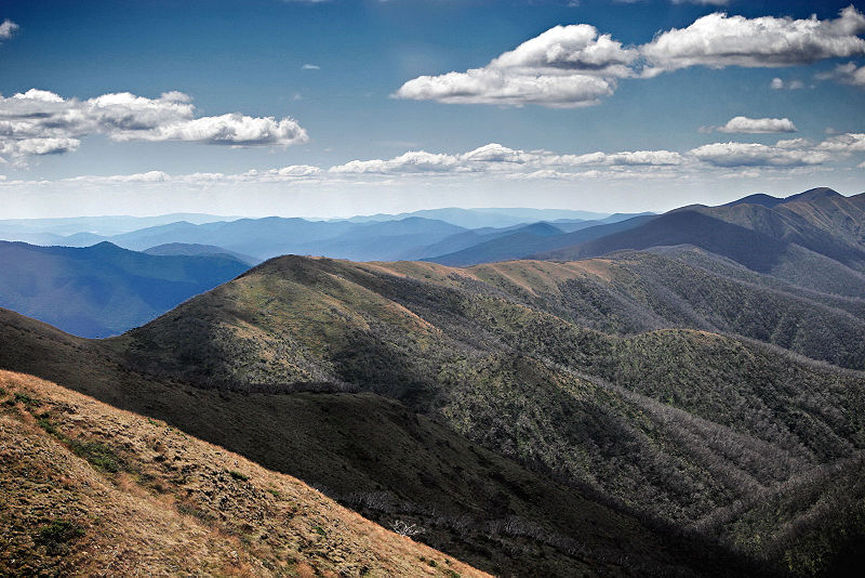
Great Dividing Range
Great Dividing Range
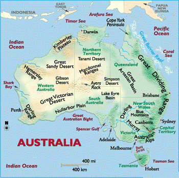
The Great Dividing Range, or the Eastern Highlands, is Australia's most substantial mountain range and the fourth longest in the world. The range stretches more than 3,600 km (2250 mi) from Dauan Island off the northeastern tip of Queensland, running the entire length of the eastern coastline through New South Wales, then into Victoria and turning west, before finally fading into the central plain at the Grampians in western Victoria. The width of the range varies from about 160 km to over 300 km.
The sharp rise between the coastal lowlands and the eastern uplands has affected Australia's climate, mainly due to orographic precipitation, and these areas of highest relief have revealed an impressive gorge country.
The sharp rise between the coastal lowlands and the eastern uplands has affected Australia's climate, mainly due to orographic precipitation, and these areas of highest relief have revealed an impressive gorge country.
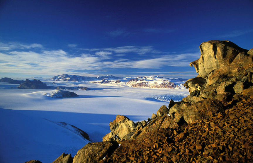
The Transantarctic Mountains in northern Victoria Land near Cape Roberts
Transantarctic Mountains
The three largest mountain ranges on the Antarctic continent are the Transantarctic Mountains (abbreviated TAM), the West Antarctica Ranges,Cenral and the East Antarctica Ranges. The Transantarctic Mountains compose a mountain range in Antarctica which extend, with some interruptions, across the continent from Cape Adare in northern Victoria Land to Coats Land. These mountains serve as the division between East Antarctica and West Antarctica. They include a number of separately named mountain groups, which are often again subdivided into smaller ranges.
The mountain range stretches between the Ross Sea and the Weddell Sea the entire length of Antarctica, thence the name. With a total length of about 3,500 km, the Transantarctic Mountains are one of the longer mountain ranges on Earth. The 100–300 km wide range forms the boundary between East Antarctica and West Antarctica. The East Antarctic Ice Sheet bounds the TAM along their entire length on the Eastern Hemisphere side, while the Western Hemisphere side of the range is bounded by the Ross Sea in Victoria Land from Cape Adare to McMurdo Sound, the Ross Ice Shelf from McMurdo Sound to near the Scott Glacier, and the West Antarctic Ice Sheet beyond.
The summits and dry valleys of the TAM are some of the few places in Antarctica not covered by ice, the highest of which rise more than 4,500 metres (14,764 ft) above sea level. The Dry Valleys lie near McMurdo Sound and represent a special Antarctic phenomenon: landscapes that are snow and ice free due to the extremely limited precipitation and ablation of ice in the valleys. The highest mountain of the TAM is 4,528 m high Mount Kirkpatrick in the Queen Alexandra Range. Isolated peaks surrounded by ice are referred to as nunataks.
