
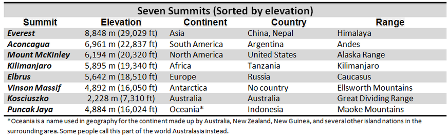
Seven Summits
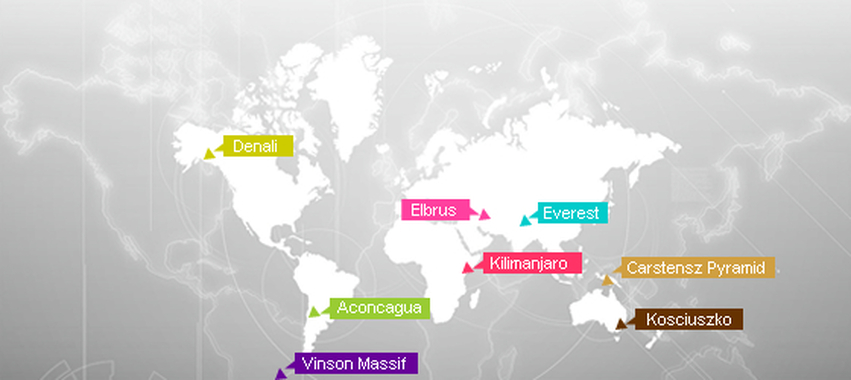
The Seven Summits are the highest mountains of each of the seven continents. Summiting all of them is regarded as a mountaineering challenge, first postulated as such and achieved on April 30, 1985 by Richard Bass.
The list
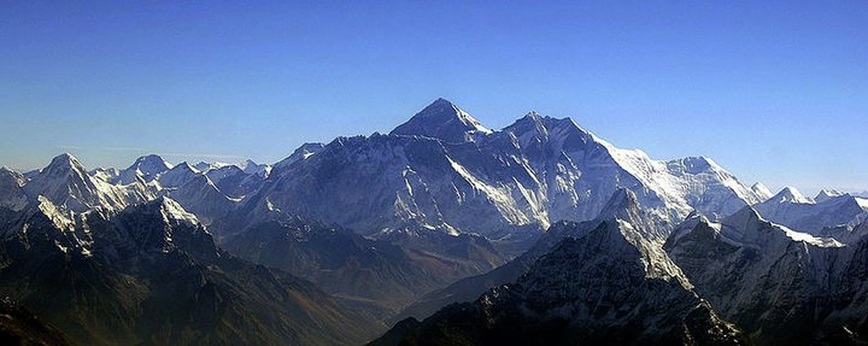
Aerial view of Mount Everest from the south-Highest Peak of Asia
Mount Everest
Mount Everest is the world's highest mountain above sea level at 8,848 metres (29,029 ft). Part of the Himalaya range in Asia, it is located on the border between Sagarmatha Zone, Nepal, and Tibet, China. The Tibetan name for Mount Everest is Chomolangma or Qomolangma (ཇོ་མོ་གླིང་མ, which means "Saint Mother"), phonetically transliterated into Chinese as Zhūmùlǎngmǎ Fēng (simplified Chinese: 珠穆朗玛峰; traditional Chinese: 珠穆朗瑪峰), or translated by meaning as Shèngmǔ Fēng (simplified Chinese: 圣母峰; traditional Chinese: 聖母峰), literally "Holy Mother". According to English accounts of the mid-19th century, the local name in Darjeeling for Mount Everest was Deodungha (meaning "holy mountain").In the early 1960s, the Nepalese government gave Mount Everest the official name Sagarmatha(सगरमाथा).A survey of India in 1856 recorded Everest. It was called Peak XV. This first published height was 8,840 metres (29,003 feet). Everest was given its official English name in 1865 by the Royal Geographical Society.
Mount Everest was climbed first in May 1953 by the Sherpa Tenzing Norgay and the New Zealander Sir Edmund Hillary after 31 years of British trials to get a man on top - the exploration of the Everest region started 1921 and first realistic try to go on top was 1922. Nazir Sabir is the only Pakistani to have climbed Mount Everest.
It is above the Death Zone where the air is too thin for a human being, so usually supplemental, or extra, oxygen is used when climbing. The Death Zone refers to the parts of Mount Everest that are above 25,000 ft above sea level.
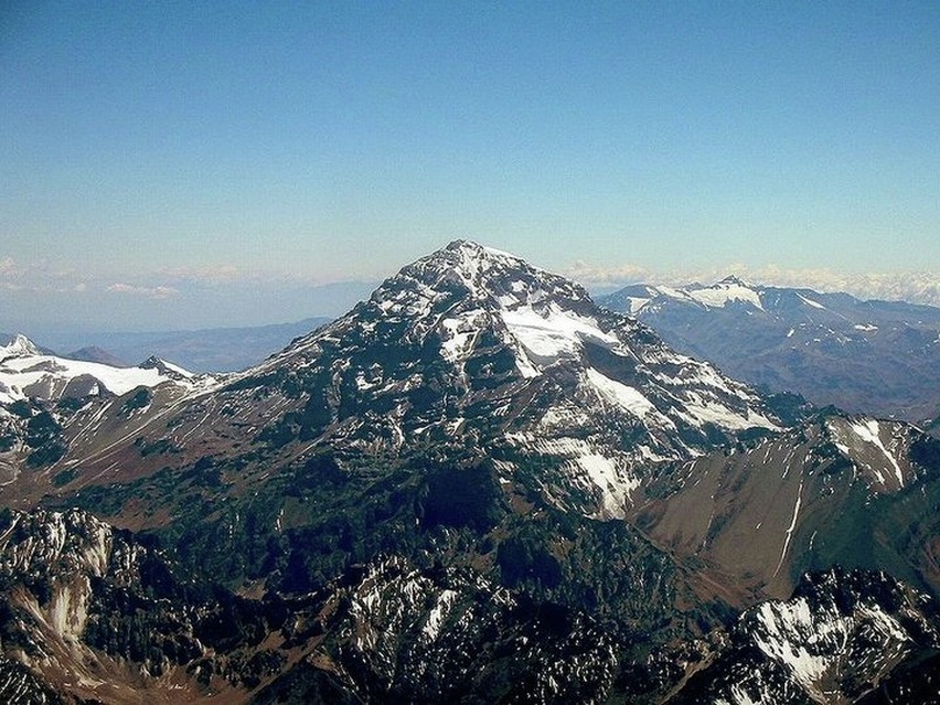
Aconcagua
Aconcagua is the highest mountain in the Americas at 6,962 m (22,841 ft), and the highest mountain outside Asia. It is located in the Andes mountain range, in the Argentine province of Mendoza. The summit is located about 5 kilometres from San Juan Province and 15 kilometres from the international border with Chile and about 50 miles northeast of the Chilean capital of Santiago. It lies 112 kilometres (70 mi) west by north of the city of Mendoza. Aconcagua is the highest peak in both the Western and Southern Hemispheres. It is one of the Seven Summits.
The first attempt on Aconcagua by a European was made in 1883 by a party led by the German geologist and explorer Paul Güssfeldt. Bribing porters with the story that there was treasure on the mountain, he approached the mountain via the Rio Volcan, making two attempts on the peak by the north-west ridge and reaching an altitude of 6,500 metres (21,300 ft). The route that he prospected is now the normal route up the mountain. The first recorded ascent was in 1897 on a British expedition led by Edward FitzGerald. The summit was reached by the Swiss guide Matthias Zurbriggen on February 12 and by two other expedition members a few days later.
The first attempt on Aconcagua by a European was made in 1883 by a party led by the German geologist and explorer Paul Güssfeldt. Bribing porters with the story that there was treasure on the mountain, he approached the mountain via the Rio Volcan, making two attempts on the peak by the north-west ridge and reaching an altitude of 6,500 metres (21,300 ft). The route that he prospected is now the normal route up the mountain. The first recorded ascent was in 1897 on a British expedition led by Edward FitzGerald. The summit was reached by the Swiss guide Matthias Zurbriggen on February 12 and by two other expedition members a few days later.
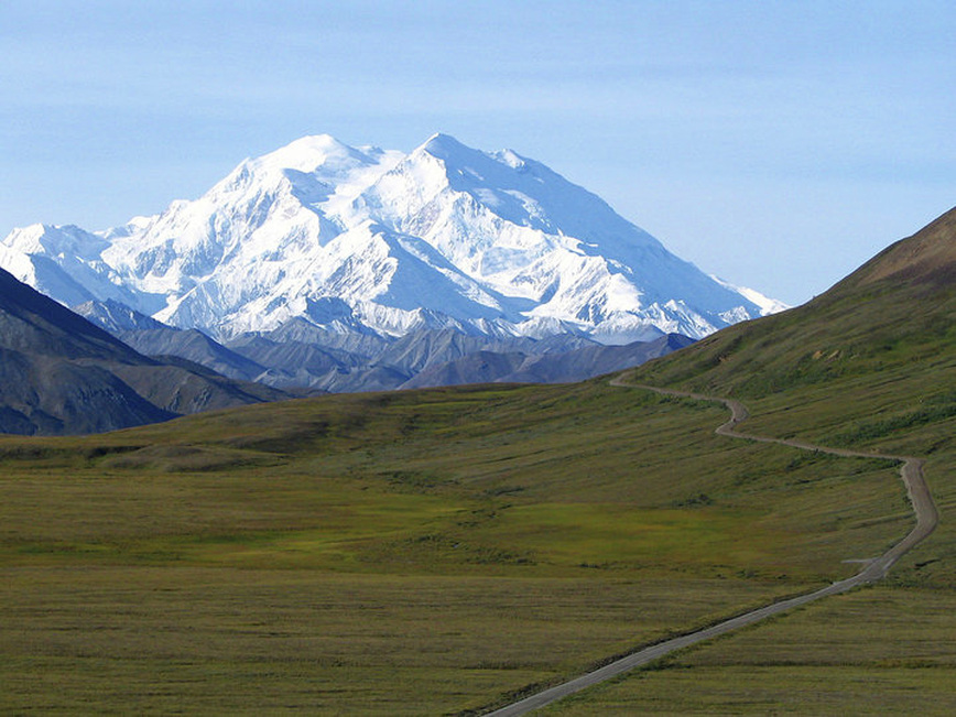
Mount McKinley or Denali-Highest Peak Of North America
Mount McKinley or Denali
Mount McKinley or Denali (Athabaskan for "The High One") in Alaska, USA is the highest mountain peak in North America and the United States, with a summit elevation of 20,320 feet (6,194 m) above sea level.The CIA World Factbook lists its summit elevation as 6,198 metres (20,335 ft).It is the centerpiece of Denali National Park and Preserve.
The historical first European sighting of Mount McKinley took place on May 6, 1794, when George Vancouver was surveying the Knik Arm of the Cook Inlet and mentioned “distant stupendous mountains” in his journal. However, he uncharacteristically left the mountain unnamed. The mountain is first named on a map by Ferdinand von Wrangell in 1839; the names Tschigmit and Tenada correspond to the locations of Mount Foraker and Mount McKinley, respectively. Von Wrangell had been chief administrator of the Russian settlements in North America from 1829–1835. The Russian explorer Lavrenty Zagoskin explored the Tanana and Kuskokwim rivers in 1843 and 1844 and was probably the first European to sight the mountain from the other side.
William Dickey, a New Hampshire born Seattleite who had been digging for gold in the sands of the Susitna River, wrote, after his return to the lower states, an account in the New York Sun (News Paper) that appeared on January 24, 1897.Dickey wrote
We named our great peak Mount McKinley, after William McKinley of Ohio, who had been nominated for the Presidency.
The first recorded attempt to climb Mount McKinley was by Judge James Wickersham in 1903, via the Peters Glacier and the North Face, now known as the Wickersham Wall. This route has tremendous avalanche danger and was not successfully climbed until 1963. Famed explorer Dr. Frederick Cook claimed the first ascent of the mountain in 1906.
The first ascent of the main summit of McKinley came on June 7, 1913, by a party led by Hudson Stuck. The first man to reach the summit was Walter Harper, an Alaska Native. Harry Karstens and Robert Tatum also made the summit.
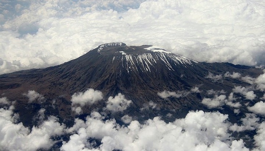
Mount Kilimanjaro-Highest Peak In Africa
Kilimanjaro
Kilimanjaro, with its three volcanic cones, Kibo, Mawenzi, and Shira, is an inactive stratovolcano in north-eastern Tanzania and the highest mountain in Africa at 5,893 metres or 19,334 ft above sea level (the Uhuru Peak / Kibo Peak).Mount Kilimanjaro is the highest freestanding mountain as well as the 4th most prominent mountain in the world, rising 5,882 metres or 19,298 ft from the base.
The exact meaning and origin of the name Kilimanjaro is unknown. It is thought to be a combination of the Swahili word Kilima (meaning "mountain") and the Kichagga word Njaro, loosely translated as "whiteness", giving the name White Mountain. The name Kibo in Kichagga means "spotted" and refers to rocks seen on snowfields. The Swahili word Uhuru translates as "freedom", a name given to commemorate Tanzanian independence from Great Britain in 1961.Another Swahili translation for Kilimanjaro is "Shining Mountain" The mountain has three peaks, Kibo, Mawenzi and Shira. The names are also Chagga words, Kibo from Kifwo in Chagga which means present, Mawenzi from Kimawenje meaning brocken and Shira meaning war as it was a platform for fighting with the Maalai. The names predate the sighting of the mountain by German explorers.
The exact meaning and origin of the name Kilimanjaro is unknown. It is thought to be a combination of the Swahili word Kilima (meaning "mountain") and the Kichagga word Njaro, loosely translated as "whiteness", giving the name White Mountain. The name Kibo in Kichagga means "spotted" and refers to rocks seen on snowfields. The Swahili word Uhuru translates as "freedom", a name given to commemorate Tanzanian independence from Great Britain in 1961.Another Swahili translation for Kilimanjaro is "Shining Mountain" The mountain has three peaks, Kibo, Mawenzi and Shira. The names are also Chagga words, Kibo from Kifwo in Chagga which means present, Mawenzi from Kimawenje meaning brocken and Shira meaning war as it was a platform for fighting with the Maalai. The names predate the sighting of the mountain by German explorers.
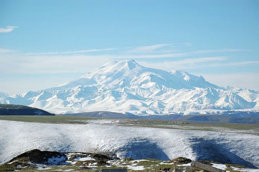
Mount Elbrus-Highest Paek Of Europe
Mount Elbrus
Mount Elbrus (Karachay-Balkar: Минги-Тау (Mingi Taw), Russian: Эльбрус, Georgian: იალბუზი) is an inactive volcano located in the western Caucasus mountain range, in Kabardino-Balkaria and Karachay-Cherkessia, Russia, near the border of Georgia. Mt. Elbrus's highest peak is the highest mountain in the Caucasus, in Russia. While there are differing authorties on how the Caucasus are distributed between Europe and Asia, many sources agree that Elbrus is also the highest mountain in all of Europe.
Mt. Elbrus (west summit) stands at 5,642 metres (18,510 ft); the east summit is slightly lower at 5,621 metres (18,442 ft). The lower of the two summits was first ascended on 10 July 1829 (Julian calendar) by Khillar Khachirov, a Karachay guide for an Imperial Russian army scientific expedition led by General Emmanuel, and the higher (by about 40 m—130 ft) in 1874 by an English expedition led by F. Crauford Grove and including Frederick Gardner, Horace Walker, and Swiss climber Peter Knubel.
Mt. Elbrus (west summit) stands at 5,642 metres (18,510 ft); the east summit is slightly lower at 5,621 metres (18,442 ft). The lower of the two summits was first ascended on 10 July 1829 (Julian calendar) by Khillar Khachirov, a Karachay guide for an Imperial Russian army scientific expedition led by General Emmanuel, and the higher (by about 40 m—130 ft) in 1874 by an English expedition led by F. Crauford Grove and including Frederick Gardner, Horace Walker, and Swiss climber Peter Knubel.
Vinson Massif
Vinson Massif is the highest mountain of Antarctica, located about 1,200 km (750 mi) from the South Pole. The mountain is about 21 km (13 mi) long and 13 km (8 mi) wide.At 4,892 metres (16,050 ft) the highest point is Mount Vinson.The massif lies in the Sentinel Range of the Ellsworth Mountains, which stand above the Ronne Ice Shelf near the base of the Antarctic Peninsula.
A high mountain, provisionally known as 'Vinson' was long suspected to be in this part of West Antarctica, but it was not actually seen until January 1958, when it was spotted by US Navy aircraft from Byrd Station.Which was named in 2006 by US-ACAN(Advisory Committee on Antarctic Names).It was named after Carl Vinson (also the namesake of an aircraft carrier), a United States Georgia Congressman who was a key supporter of funding for Antarctic research.The southern end of the massif ends at Hammer Col, which joins it to the Craddock Massif, of which the highest point is Mount Rutford (4477 m). First ascent 1966 by Nicholas Clinch and party.
A high mountain, provisionally known as 'Vinson' was long suspected to be in this part of West Antarctica, but it was not actually seen until January 1958, when it was spotted by US Navy aircraft from Byrd Station.Which was named in 2006 by US-ACAN(Advisory Committee on Antarctic Names).It was named after Carl Vinson (also the namesake of an aircraft carrier), a United States Georgia Congressman who was a key supporter of funding for Antarctic research.The southern end of the massif ends at Hammer Col, which joins it to the Craddock Massif, of which the highest point is Mount Rutford (4477 m). First ascent 1966 by Nicholas Clinch and party.
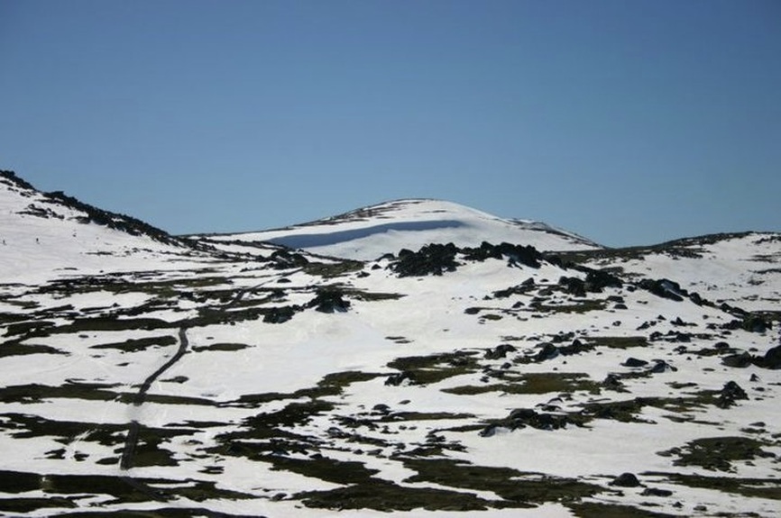
Mount Kosciuszko
Mount Kosciuszko is a mountain located in the Snowy Mountains in Kosciuszko National Park. With a height of 2,228 metres (7,310 ft) above sea level, it is the highest mountain in Australia (not including its external territories).It was named by the Polish explorer Count Paul Edmund Strzelecki in 1840, in honour of the Polish-Lithuanian national hero and hero of the American Revolutionary War General Tadeusz Kościuszko, because of its perceived resemblance to the Kościuszko Mound in Krakow.
The name of the mountain was previously spelt "Mount Kosciusko", an Anglicisation, but the spelling "Mount Kosciuszko" was officially adopted in 1997 by the Geographical Names Board of New South Wales.Various measurements of the peak originally called Kosciuszko showed it to be slightly lower than its neighbour, Mount Townsend. The names of the mountains were swapped by the New South Wales Lands Department, so that Mount Kosciuszko remains the name of the highest peak of Australia, and Mount Townsend ranks as second.The 1863 picture by Eugene von Guerard hanging in the National Gallery of Australia titled "Northeast view from the northern top of Mount Kosciusko" is actually from Mount Townsend.
The name of the mountain was previously spelt "Mount Kosciusko", an Anglicisation, but the spelling "Mount Kosciuszko" was officially adopted in 1997 by the Geographical Names Board of New South Wales.Various measurements of the peak originally called Kosciuszko showed it to be slightly lower than its neighbour, Mount Townsend. The names of the mountains were swapped by the New South Wales Lands Department, so that Mount Kosciuszko remains the name of the highest peak of Australia, and Mount Townsend ranks as second.The 1863 picture by Eugene von Guerard hanging in the National Gallery of Australia titled "Northeast view from the northern top of Mount Kosciusko" is actually from Mount Townsend.
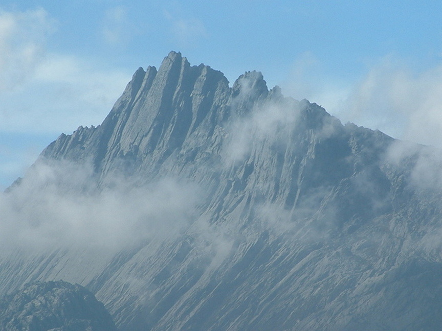
Puncak Jaya
Puncak Jaya sometimes called Mount Carstensz or the Carstensz Pyramid, is a mountain in the Sudirman Range, the western central highlands of Papua province, Indonesia. Other names include Nemangkawi in the Amungkal language, Ngga Pulu, Carstensz Toppen and Gunung Sukarno.
At 4,884 metres (16,024 ft) above sea level, Puncak Jaya is the highest mountain in Indonesia, the highest on the island of New Guinea (which comprises the Indonesian Papua provinces plus Papua New Guinea), the highest of Oceania (Australia), and the 5th highest mountain in Southeast Asia. It is also the highest point between the Himalayas and the Andes, and the highest island peak in the world. Some sources claim Mount Wilhelm, 4,509 m (14,793 ft), as the highest mountain peak in Oceania, on account of Indonesia being part of Asia (Southeast Asia).
Puncak Jaya was named "Carstensz Pyramid" after Dutch explorer Jan Carstensz who first sighted the glaciers on the peak of the mountain on a rare clear day in 1623. The sighting went unverified for over two centuries, and Carstensz was ridiculed in Europe when he said he had seen snow near the equator. This name is still used among mountaineers.Although the snowfield of Puncak Jaya was reached as early as 1909 by a Dutch explorer,Hendrik Albert Lorentz with six of his indigenous Dayak Kenyah porters recruited from the Apo Kayan in Borneo,the peak was not climbed until 1962, by an expedition led by the Austrian mountaineer Heinrich Harrer (of Seven Years in Tibet fame) with three friends — Temple, Kippax and Huizenga.
