
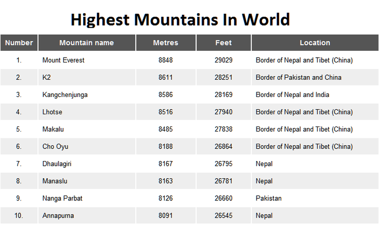
Ten Highest Mountain
What Is Mountain?
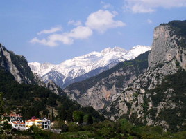
Mount Olympus
Mountains are often thought of as being a hill of over 600 metres (about 2,000 feet) those less than 600 metres are called hills.The highest point of a mountain is called the peak. A mountain's summit is the highest area on the mountain a mountain climber may reach, but a climber cannot reach the peak.
In the Oxford English Dictionary a mountain is defined as "A natural elevation of the earth surface rising more or less abruptly from the surrounding level and attaining an altitude which, relatively to the adjacent elevation, is impressive or notable."
In the Oxford English Dictionary a mountain is defined as "A natural elevation of the earth surface rising more or less abruptly from the surrounding level and attaining an altitude which, relatively to the adjacent elevation, is impressive or notable."
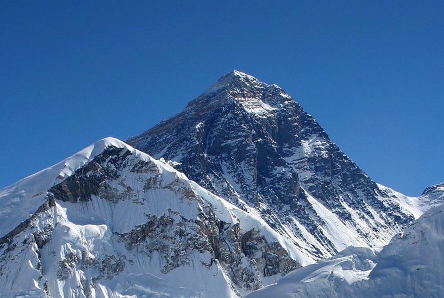
Everest from Kala Patthar in Nepal
Mount Everest
Mount Everest is the world's highest mountain above sea level at 8,848 metres (29,029 ft). Part of the Himalaya range in Asia, it is located on the border between Sagarmatha Zone, Nepal, and Tibet, China. The Tibetan name for Mount Everest is Chomolangma or Qomolangma (ཇོ་མོ་གླིང་མ, which means "Saint Mother"), phonetically transliterated into Chinese as Zhūmùlǎngmǎ Fēng (simplified Chinese: 珠穆朗玛峰; traditional Chinese: 珠穆朗瑪峰), or translated by meaning as Shèngmǔ Fēng (simplified Chinese: 圣母峰; traditional Chinese: 聖母峰), literally "Holy Mother". According to English accounts of the mid-19th century, the local name in Darjeeling for Mount Everest was Deodungha (meaning "holy mountain").In the early 1960s, the Nepalese government gave Mount Everest the official name Sagarmatha(सगरमाथा).A survey of India in 1856 recorded Everest. It was called Peak XV. This first published height was 8,840 metres (29,003 feet). Everest was given its official English name in 1865 by the Royal Geographical Society.
Mount Everest was climbed first in May 1953 by the Sherpa Tenzing Norgay and the New Zealander Sir Edmund Hillary after 31 years of British trials to get a man on top - the exploration of the Everest region started 1921 and first realistic try to go on top was 1922. Nazir Sabir is the only Pakistani to have climbed Mount Everest.
It is above the Death Zone where the air is too thin for a human being, so usually supplemental, or extra, oxygen is used when climbing. The Death Zone refers to the parts of Mount Everest that are above 25,000 ft above sea level.
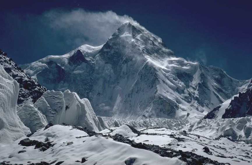
The north side of K2. The North Ridge is in the centre of the picture.
K2
K2 is the second-highest mountain on Earth after Mount Everest. With a peak elevation of 8,611 metres (28,251 ft), K2 is part of the Karakoram Range, and is located on the order between the Taxkorgan Tajik Autonomous County of Xinjiang, China, and Gilgit, in Gilgit-Baltistan of Pakistan.K2 means Karakoram 2. An unofficial name for K2 is Mount Godwin Austen, named for the man who first climbed it. K2 is known as the Savage Mountain due to the difficulty of ascent and the 2nd highest fatality rate among the 'eight thousanders' for those who climb it. For every four people who have reached the summit, one has died trying.Unlike Annapurna, the mountain with the highest fatality rate, K2 has never been climbed in winter.
The name Chogori, derived from two Balti words, chhogo ('big') and ri ('mountain') (شاہگوری) has been suggested as a local name, but evidence for its widespread use is scant. It may have been a compound name invented by Western explorers or simply a bemused reply to the question "What's that called?"It does, however, form the basis for the name Qogir (simplified Chinese: 乔戈里峰; traditional Chinese: 喬戈里峰; pinyin: Qiáogēlǐ Fēng) by which Chinese authorities officially refer to the peak.
Other local names have been suggested including Lamba Pahar ("Tall Mountain" in Urdu) and Dapsang, but are not widely used. Lacking a local name, the name Mount Godwin-Austen was suggested, in honour of Henry Godwin-Austen, an early explorer of the area, and while the name was rejected by the Royal Geographical Society it was used on several maps, and continues to be used occasionally. The surveyor's mark, K2, therefore continues to be the name by which the mountain is commonly known. It is now also used in the Balti language, rendered as Kechu or Ketu (Urdu: کے ٹو). The Italian climber Fosco Maraini argued in his account of the ascent of Gasherbrum IV that while the name of K2 owes its origin to chance, its clipped, impersonal nature is highly appropriate for so remote and challenging a mountain.
The mountain was first surveyed by a European survey team in 1856. Thomas Montgomerie was the member of the team who designated it "K2" for being the second peak of the Karakoram range. The other peaks were originally named K1, K3, K4 and K5, but were eventually renamed Masherbrum, Broad Peak, Gasherbrum II and Gasherbrum I respectively. In 1892, Martin Conway led a British expedition that reached 'Concordia' on the Baltoro Glacier.
An Italian expedition finally succeeded in ascending to the summit of K2 on July 31, 1954. The expedition was led by Ardito Desio, although the two climbers who actually reached the top were Lino Lacedelli and Achille Compagnoni. The team included a Pakistani member, Colonel Muhammad Ata-ullah, who had been a part of the 1953 American expedition.
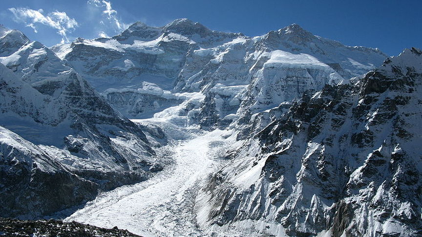
North face of Kangchenjunga as seen from Pang Pema
Kangchenjunga
Kangchenjunga (Nepali:कञ्चनजङ्घा Kanchanjaŋghā), (Limbu Language: Sewalungma (सेवालुन्ग्मा) ) in the Himalayan Range, is the third highest mountain in the world (after Mount Everest and K2), with an elevation of 8,586 metres (28,169 ft). Kangchenjunga translated means "The Five Treasures of Snows", as it contains five peaks, four of them over 8,450 metres. The treasures represent the five repositories of God, which are gold, silver, gems, grain, and holy books. Kangchenjunga is called Sewalungma in the local Limbu language, translates as 'Mountain that we offer Greetings to'. Kanchenjunga or Sewalungma is considered sacred in the Kirant religion.
Three of the five peaks (Main 8,586ft, Central 8,482ft, and South 8,494ft) are on the border of North Sikkim district of Sikkim, India and Taplejung District of Nepal, while the other two (Kangbachen 7,903,Kangchenjunga West\Yalung Kang 8,505) are completely in Taplejung District. Nepal is home to the Kanchenjunga Conservation Area Project run by the World Wildlife Fund in association with Government of Nepal.The sanctuary is home to the Red Panda and other montane animals, birds and plants. India's side of Kangchenjunga also has a protected park area called the Khangchendzonga National Park.
Although Kangchenjunga is the official spelling adopted by Douglas Freshfield, A.M. Kellas, and the Royal Geographical Society that gives the best indication of the Tibetan pronunciation, there are a number of alternative spellings which include Kangchen Dzö-nga, Khangchendzonga, Kanchenjanga, Kachendzonga, Kanchenjunga or Kangchanfanga. The final word on the use of the name Kangchenjunga came from His Highness Sir Tashi Namgyal, the Maharaja or chogyal of Sikkim, who stated that "although junga had no meaning in Tibetan, it really ought to have been Zod-nga (treasure, five) Kang-chen (snow, big) to convey the meaning correctly". Following consultations with a Lieutenant-Colonel J.L.R. Weir (HMG political agent to Sikkim), he agreed that it was best to leave it as Kangchenjunga, and thus the name remained so by acceptance and usage.
Until 1852, Kangchenjunga was assumed to be the highest mountain in the world, but calculations made by the British Great Trigonometric Survey in 1849 came to the conclusion that Mount Everest (known as Peak XV at the time) was the highest and Kangchenjunga the third-highest.Kangchenjunga was first climbed on May 25, 1955 by Joe Brown and George Band of a British expedition. The British expedition honoured the beliefs of the Sikkimese, who hold the summit sacred, by stopping a few feet short of the actual summit. Most successful summit parties since then have followed this tradition.
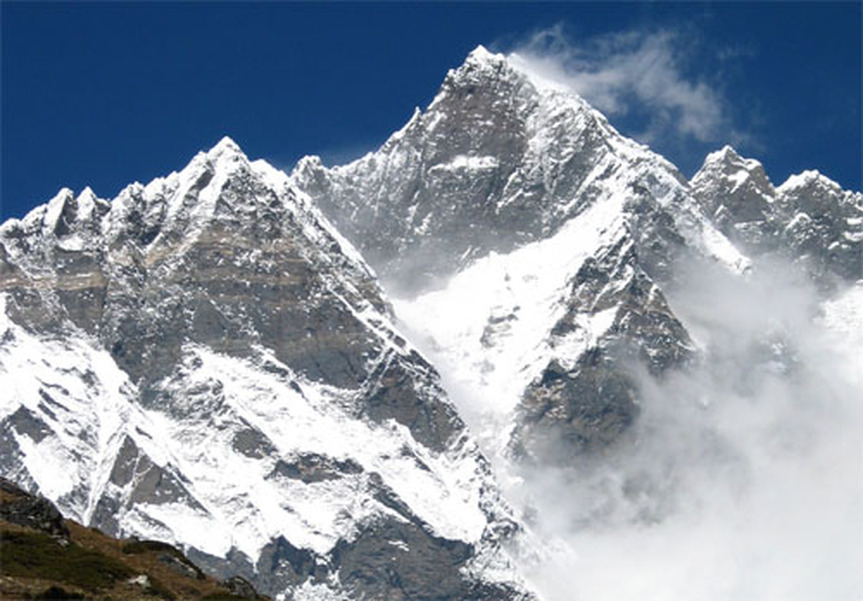
Lhotse
Lhotse (in Nepal officially ल्होत्से, in China officially Lhozê; Tibetan in Wylie transliteration: lho rtse; Chinese: 洛子峰, Pinyin: Luòzǐ Fēng) is the fourth highest mountain on Earth (after Mount Everest, K2 and Kangchenjunga) and is connected to Everest via the South Col. In addition to the main summit at 8,516 metres above sea level, Lhotse Middle (East) is 8,414 metres and Lhotse Shar is 8,383 metres. It is located at the border between Tibet (China) and the Khumbu region of Nepal.
Lhotse is best known for its proximity to Mount Everest and the fact that climbers ascending the standard route on that peak spend some time on its northwest face; see below. In fact Lhotse has the smallest topographic prominence value of any official eight-thousander, as it rises only 610 m (2,000 ft) above the South Col. Hence it is often seen as a minor eight-thousander.
However, Lhotse is a dramatic peak in its own right, due to its tremendous south face. This rises 3.2 km (2.0 mi) in only 2.25 km (1.4 mi) of horizontal distance, making it the steepest face of this size in the world. The south face has been the scene of many failed attempts, some notable fatalities, and very few ascents (one of them, by Tomo Česen, unverified).
The main summit of Lhotse was first climbed on May 18, 1956 by the Swiss team of Ernst Reiss and Fritz Luchsinger from the Swiss Mount Everest/Lhotse Expedition.
Makalu
Makalu (In Nepal officially मकालु, in China officially Makaru; Chinese: 马卡鲁山, Pinyin: Mǎkǎlǔ Shān; Makalungma in Limbu) is the fifth highest mountain in the world and is located 22 km (14 mi) east of Mount Everest, on the border between Nepal and China. One of the eight-thousanders, Makalu is an isolated peak whose shape is a four-sided pyramid.
Makalu has two notable subsidiary peaks. Kangchungtse, or Makalu II (7,678 m) lies about 3 km (2 mi) north-northwest of the main summit. Rising about 5 km (3.1 mi) north-northeast of the main summit across a broad plateau, and connected to Kangchungtse by a narrow, 7,200 m saddle, is Chomo Lonzo (7,804 m).
Makalu was first climbed on May 15, 1955 by Lionel Terray and Jean Couzy of a French expedition led by Jean Franco. Franco, G. Magnone and Sardar Gyaltsen Norbu summitted the next day, followed by Bouvier, S. Coupe, Leroux and A. Vialatte on the 17th. This was an amazing achievement at the time to have the vast majority of expedition member summit, especially on such a difficult peak. Prior to this time, summits were reached by 1-2 people at most with the rest of teams providing logistical support before turning around and heading home. The French team climbed Makalu by the north face and northeast ridge, via the saddle between Makalu and Kangchungtse (the Makalu-La), establishing the standard route.

Cho Oyu
Cho Oyu or Qowowuyag (In Nepal चोयु, Tibetan in Wylie transliteration: jo bo dbu yag; Chinese: 卓奧有山, Pinyin: Zhuó'àoyǒu Shān) is the sixth highest mountain in the world at 8118 metres above sea level. Cho Oyu lies in the Himalayas and is 20 km west of Mount Everest, at the border between China and Nepal. Cho Oyu means "Turquoise Goddess" in Tibetan.
Cho Oyu was first attempted in 1952 by an expedition organised and financed by the Joint Himalayan Committee of Great Britain as preparation for an attempt on Mount Everest the following year. The expedition was led by Eric Shipton and included Edmund Hillary & Tom Bourdillon, but technical difficulties at an ice cliff above 6,650 m (21,820 ft) proved beyond their abilities.
The mountain was first climbed on October 19, 1954, via the north-west ridge by Herbert Tichy, Joseph Jöchler and Sherpa Pasang Dawa Lama of an Austrian expedition.Cho Oyu was the fifth 8000 metre peak to be climbed, after Annapurna in June 1950, Mount Everest in May 1953, Nanga Parbat in July 1953 and K2 in July 1954.
Just a few kilometres west of Cho Oyu is Nangpa La (5,716m/18,753 ft), a glaciated pass that serves as the main trading route between the Tibetans and the Khumbu's Sherpas. Due to its proximity to this pass and the generally moderate slopes of the standard northwest ridge route, some climbers consider Cho Oyu to be the easiest 8,000 metre peak to climb[3], and it is a popular objective for professionally guided parties.
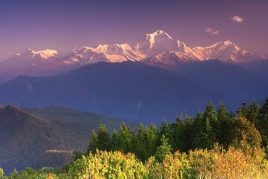
Dhaulagiri Range from Poon Hill
Dhaulagiri
Dhaulagiri (धौलागिरी) is the seventh highest mountain in the world. It forms the eastern anchor of the Dhaulagiri Himal, a subrange of the Himalaya in the Dhawalagiri Zone of north central Nepal. It lies northwest of Pokhara, an important regional town and tourist center. Across the deep gorge of the Kali Gandaki to the east lies the Annapurna Himal, home to Annapurna I, one of the other eight thousanders. Dhaulagiri means "White Mountain".
Dhaulagiri was first climbed on May 13, 1960 by Kurt Diemberger, Peter Diener, Ernst Forrer, Albin Schelbert, Nyima Dorji and Nawang Dorji, members of a Swiss/Austrian expedition. The expedition leader was Max Eiselin; they used the Northeast Ridge route which had been reconnoitered one year earlier by an Austrian expedition led by Fritz Moravec. This was also the first Himalayan climb supported by a fixed-wing aircraft. The aircraft, a Pilatus PC-6, crashed during an approach and was later abandoned in "Hidden Valley" north of the mountain.
The vast majority of ascents to date have been via the first ascent route, which is the "Normal Route" on the mountain. However ascents have been made from almost every direction. It is one of the deadliest mountains in the world, with a 40% fatality rate.
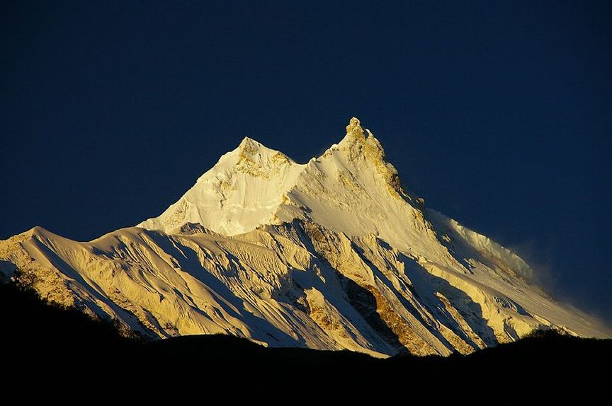
Manaslu
Manaslu (Hindi:मनास्लु, also known as Kutang) is the eighth highest mountain in the world, and is located in the Mansiri Himal, part of the Nepalese Himalayas, in the west-central part of Nepal. Its name, which means "Mountain of the Spirit", comes from the Sanskrit word Manasa, meaning "intellect" or "soul". Manaslu was first climbed on May 9, 1956 by Toshio Imanishi and Gyalzen Norbu, members of a Japanese expedition. It is said that "just as the British consider Everest their mountain, Manaslu has always been a Japanese mountain".
Manaslu at 8,163 metres (26,781 ft) above mean sea level (m.s.l) is the highest peak in the Lamjung District and is located about forty miles east of Annapurna. The mountain's long ridges and valley glaciers offer feasible approaches from all directions, and culminate in a peak that towers steeply above its surrounding landscape, and is a dominant feature when viewed from afar.
The Manaslu region offers a variety of trekking options. The popular Manaslu trekking route of 177 kilometres (110 mi), skirts the Manaslu massif over the pass down to Annapurna. The Nepalese Government only permitted trekking of this circuit in 1991. The trekking trail follows an ancient salt-trading route along the Budhi Gandaki river. Enroute, 10 peaks over 6,500 metres (21,300 ft) are visible, including a few over 7,000 metres (23,000 ft). The highest point reached along the trek route is the Larkya La at an elevation of 5,235 metres (17,175 ft). As of May 2008, the mountain has been climbed 297 times with 53 fatalities.
Manaslu Conservation Area has been established with the primary objective of achieving conservation and sustainable management of the delimited area, which includes Manaslu.
A view of Nanga Parbat from Deosai
Nanga Parbat
Nanga Parbat (Urdu: ننگا پربت) is the ninth highest mountain on Earth. Nanga Parbat translates to "Naked Mountain" in English; parbat deriving from the Sanskrit word parvata meaning "mountain, rock", and nanga an Urdu word meaning "naked".Known as the "Killer Mountain," Nanga Parbat was one of the deadliest of the eight-thousanders for climbers in the first half of the twentieth century; since that time it has been less so, though still an extremely serious climb. It is also an immense, dramatic peak that rises far above its surrounding terrain. Nanga Parbat forms the western anchor of the Himalayan Range and is the westernmost eight-thousander. It lies just south of the Indus River in the Astore District of Gilgit-Baltistan in Pakistan administered Kashmir.Not far to the north is the western end of the Karakoram range.
Nanga Parbat was first climbed on July 3, 1953 by Austrian climber Hermann Buhl, a member of a German-Austrian team. The expedition was organized by the half-brother of Willy Merkl, Karl Herrligkoffer from Munich, while the expedition leader was Peter Aschenbrenner from Innsbruck, who had participated in the 1932 and 1934 attempts. By the time of this expedition, 31 people had already died on the mountain.
Nanga Parbat was first climbed on July 3, 1953 by Austrian climber Hermann Buhl, a member of a German-Austrian team. The expedition was organized by the half-brother of Willy Merkl, Karl Herrligkoffer from Munich, while the expedition leader was Peter Aschenbrenner from Innsbruck, who had participated in the 1932 and 1934 attempts. By the time of this expedition, 31 people had already died on the mountain.
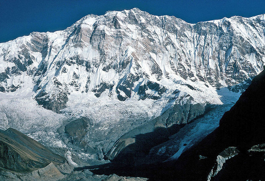
The south face of Annapurna I
Annapurna
Annapurna (Sanskrit, Nepali, Nepal Bhasa: अन्नपूर्णा) is a series of peaks in the Himalayas, a 55 km (34 mi) long massif of which the highest point, Annapurna I, stands at 8091m, making it the 10th highest summit in the world and one of the 14 "eight-thousanders". It is located east of a great gorge cut through the Himalaya Mountains by the Kali Gandaki River, which separates it from the Dhaulagiri massif. (Dhaulagiri I lies 34 km west of Annapurna I.)
Annapurna is a Sanskrit name which literally means "full of food" (feminine form), but is normally translated as Goddess of the Harvests. In Hinduism, Annapurna is "the universal and timeless kitchen goddess . . . the mother who feeds. Without her there is starvation, a universal fear: this makes Annapurna a universal goddess. . . . Her most popular shrine is located in Kashi, on the banks of the river Ganga." Her association with the giving of food (wealth) led her in time to be transformed into Lakshmi, the Goddess of Wealth.
The entire massif and surrounding area are protected within the 7,629 km2 Annapurna Conservation Area, the first and largest conservation area in Nepal, established in 1986 by the King Mahendra Trust for Nature Conservation. The Annapurna Conservation Area is home to several world-class treks, including the Annapurna Circuit.
The Annapurna peaks are the world's most dangerous mountains to climb, with a fatality to summit ratio of more than 40%.
Series of peaks
|
|
Annapurna I was the first 8,000-metre (26,200 ft) peak to be climbed. Maurice Herzog and Louis Lachenal, of a French expedition led by Maurice Herzog (including Lionel Terray, Gaston Rébuffat, Marcel Ichac, Jean Couzy, Marcel Schatz, Jacques Oudot, Francis de Noyelle), reached the summit on 3 June 1950.Its summit was the highest summit attained on Earth for three years, until the first successful ascent of Mount Everest. [However, higher non-summit points at least 8,500 metres (27,900 ft) had already been attained on Everest in the 1920s.]
The south face of Annapurna was first climbed in 1970 by Don Whillans and Dougal Haston, members of a British expedition led by Chris Bonington which included the alpinist Ian Clough, who was killed by a falling serac during the descent. They were, however, beaten to the second ascent of Annapurna by a matter of days by a British Army expedition led by Henry Day.
In 1978, The American Women's Himalayan Expedition, a team led by Arlene Blum, became the first American team to climb Annapurna I. The first summit team, comprising Vera Komarkova and Irene Miller and Sherpas Mingma Tsering and Chewang Ringjing, reached the top at 3:30 p.m. on October 15, 1978. The second summit team, Alison Chadwick-Onyszkiewicz and Vera Watson, died during this climb. (Vera Watson was survived by her husband, the computer scientist John McCarthy.)
On 3 February 1987, Polish climbers Jerzy Kukuczka and Artur Hajzer made the first winter ascent of Annapurna I.
