
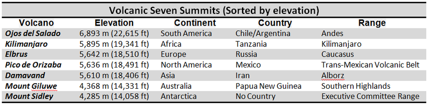
Volcanic Seven Summits
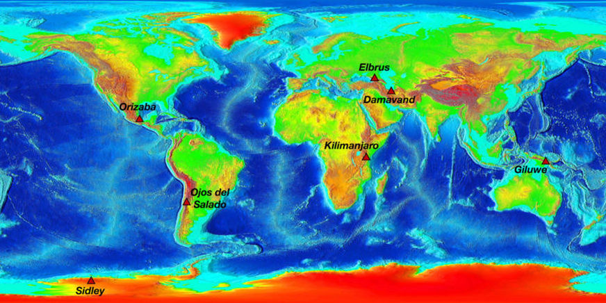
The Volcanic Seven Summits on an Elevation World Map
The Volcanic Seven Summits are the highest volcanoes on each of the seven continents, just as the Seven Summits are the highest peaks on each of the seven continents. Summiting all of the Volcanic Seven is regarded as a mountaineering challenge, first postulated as such in 1999.
The list
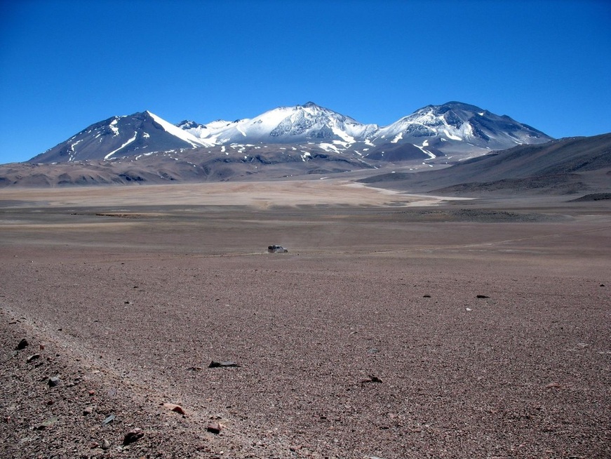
Ojos del Salado highest volcano in the South America and World
Nevado Ojos del Salado
Nevado Ojos del Salado ("Source of the Salt river" summit) is a massive stratovolcano in the Andes on the Argentina-Chile border and the highest volcano in the world at 6,893 metres (22,615 ft). It is also the second highest mountain in the Western Hemisphere and Southern Hemisphere and the highest in Chile. It is located about 600 kilometres (370 mi) north of Aconcagua, the highest mountain in the Western Hemisphere at 6,962 m (22,841 ft).
Due to its location near the Atacama desert, the mountain has very dry conditions with snow only remaining on the peak during winter. Despite the generally dry conditions, there is a permanent crater lake about 100 metres (300 ft) in diameter at an elevation of 6,390 m (20,960 ft) on the eastern side of Ojos del Salado. This is most likely the highest lake of any kind in the world.
The ascent of Ojos del Salado is mostly a hike except for the final section to the summit which is a difficult scramble that may require ropes. The first ascent was made in 1937 by Jan Alfred Szczepański and Justyn Wojsznis, members of a Polish expedition in the Andes.
Its name comes from the enormous deposits of salt that, in the form of lagoons or “eyes”, appear in its glaciers.There is no doubt that Ojos del Salado is a recently active volcano, but the question of whether it should be considered currently (or "historically") active is arguable. According to the Smithsonian Institution's Global Volcanism Program, the most recent known eruption was around 1300 years ago, with large error bars. However, there is also some evidence for a minor ash emission in 1993, which would definitely qualify the volcano as historically active. The presence of fumaroles high on the mountain and recent-looking lava flows, albeit of uncertain age, also argues in favor of a categorization as "active."

Mount Kilimanjaro highest volcano in Africa
Kilimanjaro
Kilimanjaro, with its three volcanic cones, Kibo, Mawenzi, and Shira, is an inactive stratovolcano in north-eastern Tanzania and the highest mountain in Africa at 5,893 metres or 19,334 ft above sea level (the Uhuru Peak / Kibo Peak). Mount Kilimanjaro is the highest freestanding mountain as well as the 4th most prominent mountain in the world, rising 5,882 metres or 19,298 ft from the base.
The exact meaning and origin of the name Kilimanjaro is unknown. It is thought to be a combination of the Swahili word Kilima (meaning "mountain") and the Kichagga word Njaro, loosely translated as "whiteness", giving the name White Mountain. The name Kibo in Kichagga means "spotted" and refers to rocks seen on snowfields. The Swahili word Uhuru translates as "freedom", a name given to commemorate Tanzanian independence from Great Britain in 1961.Another Swahili translation for Kilimanjaro is "Shining Mountain" The mountain has three peaks, Kibo, Mawenzi and Shira. The names are also Chagga words, Kibo from Kifwo in Chagga which means present, Mawenzi from Kimawenje meaning brocken and Shira meaning war as it was a platform for fighting with the Maalai. The names predate the sighting of the mountain by German explorers.
The exact meaning and origin of the name Kilimanjaro is unknown. It is thought to be a combination of the Swahili word Kilima (meaning "mountain") and the Kichagga word Njaro, loosely translated as "whiteness", giving the name White Mountain. The name Kibo in Kichagga means "spotted" and refers to rocks seen on snowfields. The Swahili word Uhuru translates as "freedom", a name given to commemorate Tanzanian independence from Great Britain in 1961.Another Swahili translation for Kilimanjaro is "Shining Mountain" The mountain has three peaks, Kibo, Mawenzi and Shira. The names are also Chagga words, Kibo from Kifwo in Chagga which means present, Mawenzi from Kimawenje meaning brocken and Shira meaning war as it was a platform for fighting with the Maalai. The names predate the sighting of the mountain by German explorers.
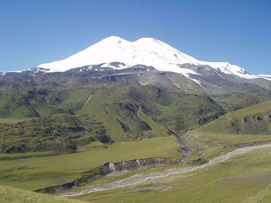
Mount Elbrus highest volcano in Europe
Mount Elbrus
Mount Elbrus is an dormant volcano located in the western Caucasus mountain range, in Kabardino-Balkaria and Karachay-Cherkessia, Russia, near the border of Georgia. Mt. Elbrus's highest peak is the highest mountain in the Caucasus, in Russia. While there are differing authorties on how the Caucasus are distributed between Europe and Asia, many sources agree that Elbrus is also the highest mountain in all of Europe.
Mt. Elbrus (west summit) stands at 5,642 metres (18,510 ft); the east summit is slightly lower at 5,621 metres (18,442 ft). The lower of the two summits was first ascended on 10 July 1829 (Julian calendar) by Khillar Khachirov, a Karachay guide for an Imperial Russian army scientific expedition led by General Emmanuel, and the higher (by about 40 m—130 ft) in 1874 by an English expedition led by F. Crauford Grove and including Frederick Gardner, Horace Walker, and Swiss climber Peter Knubel.
Mt. Elbrus (west summit) stands at 5,642 metres (18,510 ft); the east summit is slightly lower at 5,621 metres (18,442 ft). The lower of the two summits was first ascended on 10 July 1829 (Julian calendar) by Khillar Khachirov, a Karachay guide for an Imperial Russian army scientific expedition led by General Emmanuel, and the higher (by about 40 m—130 ft) in 1874 by an English expedition led by F. Crauford Grove and including Frederick Gardner, Horace Walker, and Swiss climber Peter Knubel.
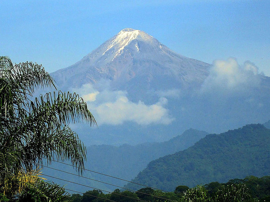
Pico de Orizaba highest volcano in North America
Pico de Orizaba
The Pico de Orizaba, or Citlaltépetl (from Nahuatl citlal star, and tepētl mountain) is a stratovolcano, the highest mountain in Mexico and the third highest in North America. Pico de Orizaba is located at a distance of 100 kilometres (62 mi) from the shores of the Gulf of Mexico. Orizaba is located 200 kilometres (120 mi) miles east of Mexico City lies on the border between the states of Veracruz and Puebla.
It rises 5,636 metres (18,491 ft) above sea level in the eastern end of the Trans-Mexican Volcanic Belt. The volcano is currently dormant but not extinct with the last eruption taking place during the 19th century. It is the second most prominent volcanic peak by prominence in the world after Africa's Mount Kilimanjaro.
In 1839, Enrique Galeotti was the first European to explore the volcano, but did not hike to the summit. During the American occupation of Mexico in 1848, two American soldiers, F. Maynard and William F. Raynolds, were the first known hikers to reach the summit of Pico de Orizaba.
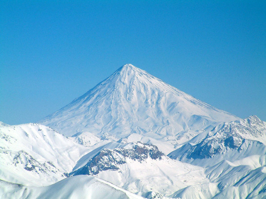
Damavand highest volcano in Asia
Mount Damavand
Mount Damavand (Persian: دماوند ), a potentially active volcano and the highest peak in Iran, has a special place in Persian mythology and folklore. Mount Damavand is depicted on the reverse of the Iranian 10,000 rials banknote. It is located in the middle Alborz Range, adjacent to Vararu, Sesang, Gol-e Zard and Mianrud the highest volcano in all of Asia. It rises 5,610 m (18,406 ft) above sea level. It is a potentially active volcano, since there are fumaroles near the summit crater emitting sulfur, which were known to be active on July 6, 2007.
The mountain is located near the southern coast of the Caspian Sea, in Amol county, Mazandaran, 66 kilometres (41 miles) northeast of Tehran.
The earliest recorded ascent of Damavand was made in 905 by Abu Dolaf Kazraji, although others unknown may have preceded him. Three centuries later Yaqut, the great Byzantine/Arab geographer, attempted to climb Damavand, but failed to reach the summit. However, the local people who served him as guides gave him a detailed description of the summit which he incorporated into his famous "Dictionary of Geography", and which conforms perfectly with the geographical reality. At approximately the same time Ebn Esfandiar noted that the ascent from Ask took around two days. Apparently climbs of Damavand were not uncommon during the early 13th century, before the Mongol invasion under Hulagu Khan swept, and destroyed, everything before it.
Actually, at the time of Thompson's ascent in 1837, there were ascents regularly being made by iranians, to gather sulphur from the summit for commercial purposes; Thompson himself mentions this in his article in the Royal Geographic society magazine of 1838. This commercial activity was mentionned in Nasser-i Khosrow's medieval book of travels.
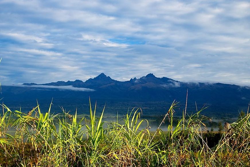
Mount Giluwe highest volcano in Australia
Mount Giluwe
Mount Giluwe is the second highest mountain in Papua New Guinea at 4,367 metres (14,327 ft) (Mount Wilhelm being the highest). It is located in the Southern Highlands province and is an old shield volcano with vast alpine grasslands. Ancient volcanic plugs form its two summits, with the central peak the highest and an east peak about 2 kilometres (1.2 mi) away at 4,300 m (14,108 ft). Giluwe has the distinction of being the highest volcano on the Australian continent, and is thus one of the Volcanic Seven Summits.
In 1934, Australian explorers Mick Leahy, and his brother Dan, were the first Westerners to reach the area and to discover and climb Mount Giluwe. However, another explorer Jack Hides also laid claim to be the first to discover Mount Giluwe after viewing the peaks from the west in 1935. Hides aptly named them the Minaret Mountains. However the name did not stick after Leahy went to London in 1935 and set up a hearing into the two opposing claims at the Royal Geographical Society. Leahy delivered his address on 21 November 1935 and the following year Leahy was awarded a grant from the Society and published his discoveries in their journal.
In 1934, Australian explorers Mick Leahy, and his brother Dan, were the first Westerners to reach the area and to discover and climb Mount Giluwe. However, another explorer Jack Hides also laid claim to be the first to discover Mount Giluwe after viewing the peaks from the west in 1935. Hides aptly named them the Minaret Mountains. However the name did not stick after Leahy went to London in 1935 and set up a hearing into the two opposing claims at the Royal Geographical Society. Leahy delivered his address on 21 November 1935 and the following year Leahy was awarded a grant from the Society and published his discoveries in their journal.
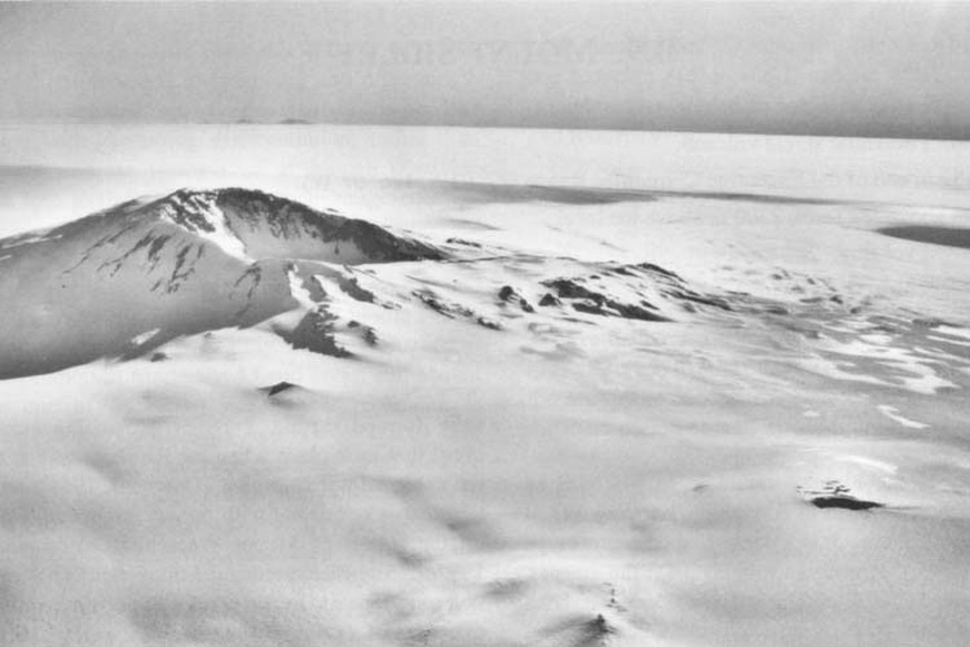
Mount Sidley highest volcano in Antarctica
Mount Sidley
Mount Sidley is the highest volcano in Antarctica, a member of the Volcanic Seven Summits, with a summit elevation of 4,181 - 4,285 metres (13,717 - 14,058 ft). It is a massive, mainly snow-covered shield volcano which is the highest and most imposing of the five volcanic mountains that comprise the Executive Committee Range of Marie Byrd Land. The feature is marked by a spectacular 5 km wide caldera on the southern side and stands NE of Mount Waesche in the southern part of the range.
The mountain was discovered by Rear Admiral Richard E. Byrd on an airplane flight, November 18, 1934, and named by him for Mabelle E. Sidley, the daughter of William Horlick who was a contributor to the 1933 - 35 Byrd Antarctic Expedition. Despite its lofty status, the volcano languishes in obscurity due to its extremely remote location. It is little known even in the mountaineering world compared to the far more famous Mount Erebus, the second highest Antarctic volcano which is located near the U.S. and New Zealand bases on Ross Island. The first recorded ascent of Mount Sidley was by New Zealander Bill Atkinson on January 11, 1990, whilst working in support of a USAP scientific field party. It was recently ascended in January 2011, by an expedition organised by Adventure Network International.
The mountain was discovered by Rear Admiral Richard E. Byrd on an airplane flight, November 18, 1934, and named by him for Mabelle E. Sidley, the daughter of William Horlick who was a contributor to the 1933 - 35 Byrd Antarctic Expedition. Despite its lofty status, the volcano languishes in obscurity due to its extremely remote location. It is little known even in the mountaineering world compared to the far more famous Mount Erebus, the second highest Antarctic volcano which is located near the U.S. and New Zealand bases on Ross Island. The first recorded ascent of Mount Sidley was by New Zealander Bill Atkinson on January 11, 1990, whilst working in support of a USAP scientific field party. It was recently ascended in January 2011, by an expedition organised by Adventure Network International.
