
Earth's Oceans
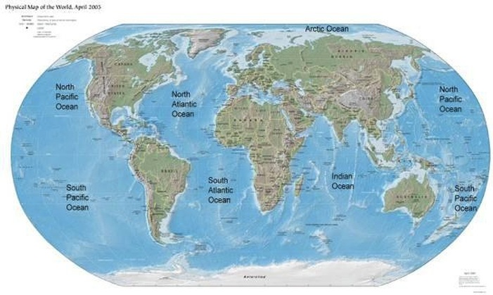
An ocean is a large area of salt water between continents. Oceans are very big and they join smaller seas together. Together, the oceans are like one "ocean", because all the "oceans" are joined. Oceans (or marine biomes) cover 70% of our planet.The largest ocean is the Pacific Ocean. It covers 1/3 (one third) of the Earth's surface. The smallest ocean is the Arctic Ocean. Different water movements separate the Southern Ocean from the Atlantic, Pacific and Indian oceans. It is also known as the Antarctic Ocean, because it covers the area around Antarctica. Older maps may not use the names Arctic Ocean and Southern Ocean. The deepest ocean is the Pacific ocean. The deepest point is the Mariana Trench, being about 11,000 metres (36,200 feet) deep. The deep ocean is characterized by cold temperatures, high pressure, and complete darkness. Some very unusual organisms live in this part of the ocean. They do not require energy from the sun to survive, because they use chemicals from deep inside the earth.
It is wrong to say that the oceans are blue because the water reflects the blue sky. Water has a very slight blue color that can only be seen in a very large amount of water. However, the main cause of the blue or blue/green color is that water absorbs the red part of the incoming light, and reflects the green and blue part of the light.
The name of earth oceans are
- Pacific Ocean
- Atlantic Ocean
- Indian Ocean
- Southern Ocean
- Arctic Ocean
The Pacific Ocean
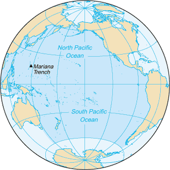
The Pacific Ocean is the largest of the Earth's oceanic divisions. It extends from the Arctic in the north to the Southern Ocean in the south, bounded by Asia and Australia in the west, and the Americas in the east.At 169.2 million square kilometres (63.8 million square miles) in area, this largest division of the World Ocean and, in turn, the hydrosphere – covers about 46% of the Earth's water surface and about 30% of its total surface.The equator subdivides it into the North Pacific Ocean and South Pacific Ocean, with two exceptions: the Galápagos and Gilbert Islands, while straddling the equator, are deemed wholly within the South Pacific.The Mariana Trench in the western North Pacific is the deepest point in the Pacific and in the world, reaching a depth of 10,911 metres (35,797 ft).The Pacific Ocean was sighted by Europeans early in the 16th century, first by the Spanish explorer Vasco Núñez de Balboa who crossed the Isthmus of Panama in 1513 and named it Mar del Sur (South Sea). Its current name is however derived from the Luso-Latin macaronic Tepre Pacificum, "peaceful sea", bestowed upon it by the Portuguese explorer Ferdinand Magellan.
The Pacific Ocean encompasses approximately one-third of the Earth's surface, having an area of 179.7 million square kilometres (69.4 million sq mi and 161 million cubic mi) significantly larger than Earth's entire landmass, with room for another Africa to spare. As a comparison, it is almost 400 times the size of adjacent California.Extending approximately 15,500 kilometres (9,600 mi) from the Bering Sea in the Arctic to the northern extent of the circumpolar Southern Ocean at 60° S (older definitions extend it to Antarctica's Ross Sea), the Pacific reaches its greatest east-west width at about 5°N latitude, where it stretches approximately 19,800 kilometres (12,300 mi) from Indonesia to the coast of Colombia and Peru halfway across the world, and more than five times the diameter of the Moon. The lowest known point on earth the Mariana Trench lies 10,911 metres (35,797 ft) below sea level. Its average depth is 4028~4188metres (14,000 ft).
The Pacific contains about 25,000 islands (more than the total number in the rest of the world's oceans combined), the majority of which are found south of the equator. Including partially submerged islands, the figure is substantially higher.The Pacific Ocean is currently shrinking from plate tectonics, while the Atlantic Ocean is increasing in size, by roughly an inch per year (2–3 cm/yr) on 3 sides, roughly averaging 0.2 square miles (0.5 km2) a year.
Along the Pacific Ocean's irregular western margins lie many seas, the largest of which are the Celebes Sea, Coral Sea, East China Sea, Philippine Sea, Sea of Japan, South China Sea, Sulu Sea, Tasman Sea, and Yellow Sea. The Strait of Malacca joins the Pacific and the Indian Oceans on the west, and Drake Passage and the Straits of Magellan link the Pacific with the Atlantic Ocean on the east. To the north, the Bering Strait connects the Pacific with the Arctic Ocean.As the Pacific straddles the 180th meridian, the West Pacific (or western Pacific, near Asia) is in the Eastern Hemisphere, while the East Pacific (or eastern Pacific, near the Americas) is in the Western Hemisphere.For most of Magellan's voyage from the Strait of Magellan to the Philippines, the explorer indeed found the ocean peaceful. However, the Pacific is not always peaceful. Many tropical storms batter the islands of the Pacific. The lands around the Pacific Rim are full of volcanoes and often affected by earthquakes. Tsunamis, caused by underwater earthquakes, have devastated many islands and destroyed entire towns.
The volume of the Pacific Ocean is approximately 622 million cubic km. Water temperatures in the Pacific vary from freezing in the poleward areas to about 30 °C (86 °F) near the equator. Salinity also varies latitudinally. The water near the equator is less salty than that found in the mid-latitudes because of abundant equatorial precipitation throughout the year. Poleward of the temperate latitudes salinity is also low, because little evaporation of seawater takes place in these frigid areas.
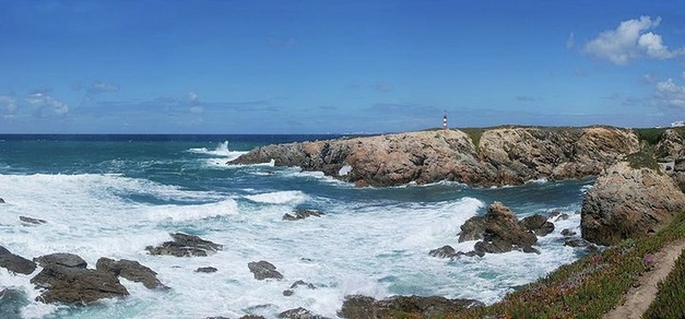
The Atlantic Ocean as seen from the western coast of Portugal
The Atlantic Ocean
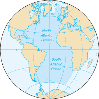
The Atlantic Ocean is the second-largest of the world's oceanic divisions. With a total area of about 106,400,000 square kilometres (41,100,000 sq mi), it covers approximately twenty percent of the Earth's surface and about twenty-six percent of its water surface area. The first part of its name refers to the Atlas of Greek mythology, making the Atlantic the "Sea of Atlas".The oldest known mention of "Atlantic" is in The Histories of Herodotus around 450 BC. Another name historically used was the ancient term Ethiopic Ocean, derived from Ethiopia, whose name was sometimes used as a synonym for all of Africa and thus for the ocean. Before Europeans discovered other oceans, the term "ocean" itself was synonymous with the waters beyond the Strait of Gibraltar that we now know as the Atlantic. The Greeks believed this ocean to be a gigantic river encircling the world.The Atlantic Ocean occupies an elongated, S-shaped basin extending longitudinally between the Americas to the west, and europe,asia and Africa to the east. As one component of the interconnected global ocean, it is connected in the north to the Arctic Ocean (which is sometimes considered a sea of the Atlantic), to the Pacific Ocean in the southwest, the Indian Ocean in the southeast, and the Southern Ocean in the south. (Other definitions describe the Atlantic as extending southward to Antarctica.) The equator subdivides it into the North Atlantic Ocean and South Atlantic Ocean.
The Atlantic Ocean is bounded on the west by North and South America. It connects to the Arctic Ocean through the Denmark Strait, Greenland Sea, Norwegian Sea and Barents Sea. To the east, the boundaries of the ocean proper are Europe; the Strait of Gibraltar (where it connects with the Mediterranean Sea – one of its marginal seas – and, in turn, the Black Sea) and Africa.
In the southeast, the Atlantic merges into the Indian Ocean. The 20° East meridian, running south from Cape Agulhas to Antarctica defines its border. Some authorities show it extending south to Antarctica, while others show it bounded at the 60° parallel by the Southern Ocean.In the southwest, the Drake Passage connects it to the Pacific Ocean.
The man-made Panama Canal links the Atlantic and Pacific. Besides those mentioned, other large bodies of water adjacent to the Atlantic are the Caribbean Sea; the Gulf of Mexico; Hudson Bay; the Arctic Ocean; the Mediterranean Sea; the North Sea; the Baltic Sea and the Celtic Sea.Covering approximately 22% of Earth's surface, the Atlantic is second in size to the Pacific. With its adjacent seas, it occupies an area of about 106,400,000 square kilometres (41,100,000 sq mi); without them, it has an area of 82,400,000 square kilometres (31,800,000 sq mi). The land that drains into the Atlantic covers four times that of either the Pacific or Indian oceans. The volume of the Atlantic with its adjacent seas is 354,700,000 cubic kilometers (85,100,000 cu mi) and without them 323,600,000 cubic kilometres (77,640,000 cu mi).
The average depth of the Atlantic, with its adjacent seas, is 3,339 metres (10,955 ft); without them it is 3,926 metres (12,881 ft). The greatest depth, 8,605 metres (28,232 ft), is in the Puerto Rico Trench. The Atlantic's width varies from 2,848 kilometres (1,770 mi) between Brazil and Sierra Leone to over 6,400 km (4,000 mi) in the south.
Surface water temperatures, which vary with latitude, current systems, and season and reflect the latitudinal distribution of solar energy, range from below −2 °C (28.4 °F). Maximum temperatures occur north of the equator, and minimum values are found in the polar regions. In the middle latitudes, the area of maximum temperature variations, values may vary by 7-8 °C (12-15 °F).
The Indian Ocean
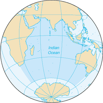
The Indian Ocean is the third largest of the world's oceanic divisions, covering about 20% of the water on the Earth's surface.It is bounded on the north by the Indian subcontinent; on the west by East Africa; on the east by Indochina, the Sunda Islands, and Australia; and on the south by the Southern Ocean (or, depending on definition, by Antarctica). It is the only ocean to be named after a country India.
As one component of the interconnected global ocean, the Indian Ocean is delineated from the Atlantic Ocean by the 20° east meridian running south from Cape Agulhas, and from the Pacific by the meridian of 146°55' east.The northernmost extent of the Indian Ocean is approximately 30° north in the Persian Gulf.
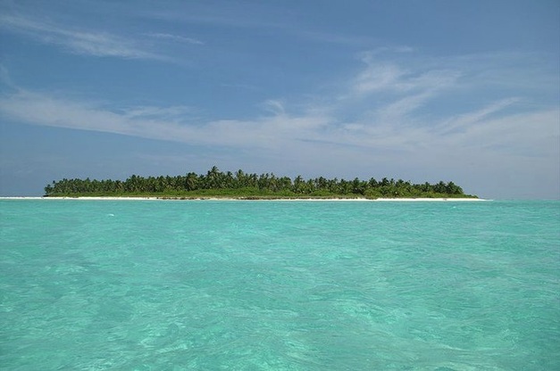
The Indian Ocean has asymmetric ocean circulation.This ocean is nearly 10,000 kilometres (6,200 mi) wide at the southern tips of Africa and Australia; its area is 73,556,000 square kilometres (28,400,000 mi2), including the Red Sea and the Persian Gulf.The ocean's volume is estimated to be 292,131,000 cubic kilometres (70,086,000 mi3).Small islands dot the continental rims. Island nations within the ocean are Madagascar, the world's fourth largest island; Reunion Island; Comoros; Seychelles; Maldives; Mauritius; and Sri Lanka. The archipelago of Indonesia borders the ocean on the east.
The African, Indian, and Antarctic crustal plates converge in the Indian Ocean at the Rodrigues Triple Point. Their junctures are marked by branches of the mid-oceanic ridge forming an inverted Y, with the stem running south from the edge of the continental shelf near Mumbai, India. The eastern, western, and southern basins thus formed are subdivided into smaller basins by ridges.
The ocean's continental shelves are narrow, averaging 200 kilometres (125 mi) in width. An exception is found off Australia's western coast, where the shelf width exceeds 1,000 kilometres (600 mi). The average depth of the ocean is 3,890 metres (12,760 ft). Its deepest point, 7258 meters deep, is in the Java Trench. North of 50° south latitude, 86% of the main basin is covered by pelagic sediments, of which more than half is globigerina ooze. The remaining 14% is layered with terrigenous sediments. Glacial outwash dominates the extreme southern latitudes.
The major choke points include Bab el Mandeb, Strait of Hormuz, the Lombok Strait, the Strait of Malacca and the Palk Strait. Seas include Gulf of Aden, Andaman Sea, Arabian Sea, Bay of Bengal, Great Australian Bight, Laccadive Sea, Gulf of Mannar, Mozambique Channel, Gulf of Oman, Persian Gulf, Red Sea, and other tributary water bodies. It is artificially connected to the Mediterranean Sea via the Suez Canal, accessible via the Red Sea.
Deep water circulation is controlled primarily by inflows from the Atlantic Ocean, the Red Sea, and Antarctic currents. North of 20° south latitude the minimum surface temperature is 22 °C (72 °F), exceeding 28 °C (82 °F) to the east. Southward of 40° south latitude, temperatures drop quickly.
As one component of the interconnected global ocean, the Indian Ocean is delineated from the Atlantic Ocean by the 20° east meridian running south from Cape Agulhas, and from the Pacific by the meridian of 146°55' east.The northernmost extent of the Indian Ocean is approximately 30° north in the Persian Gulf.
The Indian Ocean has asymmetric ocean circulation.This ocean is nearly 10,000 kilometres (6,200 mi) wide at the southern tips of Africa and Australia; its area is 73,556,000 square kilometres (28,400,000 mi2), including the Red Sea and the Persian Gulf.The ocean's volume is estimated to be 292,131,000 cubic kilometres (70,086,000 mi3).Small islands dot the continental rims. Island nations within the ocean are Madagascar, the world's fourth largest island; Reunion Island; Comoros; Seychelles; Maldives; Mauritius; and Sri Lanka. The archipelago of Indonesia borders the ocean on the east.
The African, Indian, and Antarctic crustal plates converge in the Indian Ocean at the Rodrigues Triple Point. Their junctures are marked by branches of the mid-oceanic ridge forming an inverted Y, with the stem running south from the edge of the continental shelf near Mumbai, India. The eastern, western, and southern basins thus formed are subdivided into smaller basins by ridges.
The ocean's continental shelves are narrow, averaging 200 kilometres (125 mi) in width. An exception is found off Australia's western coast, where the shelf width exceeds 1,000 kilometres (600 mi). The average depth of the ocean is 3,890 metres (12,760 ft). Its deepest point, 7258 meters deep, is in the Java Trench. North of 50° south latitude, 86% of the main basin is covered by pelagic sediments, of which more than half is globigerina ooze. The remaining 14% is layered with terrigenous sediments. Glacial outwash dominates the extreme southern latitudes.
The major choke points include Bab el Mandeb, Strait of Hormuz, the Lombok Strait, the Strait of Malacca and the Palk Strait. Seas include Gulf of Aden, Andaman Sea, Arabian Sea, Bay of Bengal, Great Australian Bight, Laccadive Sea, Gulf of Mannar, Mozambique Channel, Gulf of Oman, Persian Gulf, Red Sea, and other tributary water bodies. It is artificially connected to the Mediterranean Sea via the Suez Canal, accessible via the Red Sea.
Deep water circulation is controlled primarily by inflows from the Atlantic Ocean, the Red Sea, and Antarctic currents. North of 20° south latitude the minimum surface temperature is 22 °C (72 °F), exceeding 28 °C (82 °F) to the east. Southward of 40° south latitude, temperatures drop quickly.
The Southern Ocean
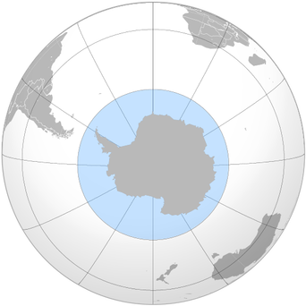
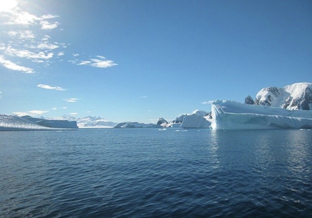
The Southern Ocean, also known as the Great Southern Ocean, the Antarctic Ocean and the South Polar Ocean, comprises the southernmost waters of the World Ocean, generally taken to be south of 60°S latitude and encircling Antarctica. It is usually regarded as the fourth largest of the five principal oceanic divisions. This ocean zone is where cold, northward flowing waters from the Antarctic mix with warmer sub-Antarctic waters.
Geographers disagree on the Southern Ocean's northern boundary or even its existence, with some considering the waters part of the South Pacific, South Atlantic, and Indian Oceans instead. Others regard the Antarctic Convergence, an ocean zone which fluctuates seasonally, as separating the Southern Ocean from other oceans, rather than the 60th parallel.Australian authorities regard the Southern Ocean as lying immediately south of Australia.
The Southern Ocean includes the Antarctic Circumpolar Current (which circulates around Antarctica), the Amundsen Sea, Bellingshausen Sea, parts of the Drake Passage, Ross Sea, Cooperation Sea, the Cosmonaut Sea, a small part of the Scotia Sea, and Weddell Sea.The Southern Ocean differs from the other oceans in that its largest boundary, the northern boundary, does not abut a landmass, but merges into the Atlantic, Indian and Pacific Oceans. This calls into question why geographers should consider the Southern Ocean a separate ocean, as opposed to a southward extension of the other three oceans. One reason stems from the fact that much of the water of the Southern Ocean differs from the water in the other oceans. Because of the Antarctic Circumpolar Current, that water gets transported around the Southern Ocean fairly rapidly, so that the water in the Southern Ocean south of, for example, South America, resembles the water in the Southern Ocean south of New Zealand more closely than it resembles the water in the mid-Indian Ocean.
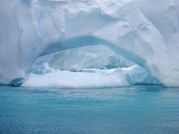
Several processes operate along the coast of Antarctica to produce, in the Southern Ocean, types of water masses not produced elsewhere in the oceans of the Southern Hemisphere. One of these is the Antarctic Bottom Water, a very cold, highly saline, dense water that forms under sea ice.Sea-temperatures vary from about −2 to 10 °C (28 to 50 °F). Cyclonic storms travel eastward around the continent and frequently become intense because of the temperature-contrast between ice and open ocean. The ocean-area from about latitude 40 south to the Antarctic Circle has the strongest average winds found anywhere on Earth. In winter the ocean freezes outward to 65 degrees south latitude in the Pacific sector and 55 degrees south latitude in the Atlantic sector, lowering surface temperatures well below 0 degrees Celsius; at some coastal points intense persistent drainage winds from the interior keep the shoreline ice-free throughout the winter.
Geographers disagree on the Southern Ocean's northern boundary or even its existence, with some considering the waters part of the South Pacific, South Atlantic, and Indian Oceans instead. Others regard the Antarctic Convergence, an ocean zone which fluctuates seasonally, as separating the Southern Ocean from other oceans, rather than the 60th parallel.Australian authorities regard the Southern Ocean as lying immediately south of Australia.
The Southern Ocean includes the Antarctic Circumpolar Current (which circulates around Antarctica), the Amundsen Sea, Bellingshausen Sea, parts of the Drake Passage, Ross Sea, Cooperation Sea, the Cosmonaut Sea, a small part of the Scotia Sea, and Weddell Sea.The Southern Ocean differs from the other oceans in that its largest boundary, the northern boundary, does not abut a landmass, but merges into the Atlantic, Indian and Pacific Oceans. This calls into question why geographers should consider the Southern Ocean a separate ocean, as opposed to a southward extension of the other three oceans. One reason stems from the fact that much of the water of the Southern Ocean differs from the water in the other oceans. Because of the Antarctic Circumpolar Current, that water gets transported around the Southern Ocean fairly rapidly, so that the water in the Southern Ocean south of, for example, South America, resembles the water in the Southern Ocean south of New Zealand more closely than it resembles the water in the mid-Indian Ocean.
Several processes operate along the coast of Antarctica to produce, in the Southern Ocean, types of water masses not produced elsewhere in the oceans of the Southern Hemisphere. One of these is the Antarctic Bottom Water, a very cold, highly saline, dense water that forms under sea ice.Sea-temperatures vary from about −2 to 10 °C (28 to 50 °F). Cyclonic storms travel eastward around the continent and frequently become intense because of the temperature-contrast between ice and open ocean. The ocean-area from about latitude 40 south to the Antarctic Circle has the strongest average winds found anywhere on Earth. In winter the ocean freezes outward to 65 degrees south latitude in the Pacific sector and 55 degrees south latitude in the Atlantic sector, lowering surface temperatures well below 0 degrees Celsius; at some coastal points intense persistent drainage winds from the interior keep the shoreline ice-free throughout the winter.
The Arctic Ocean
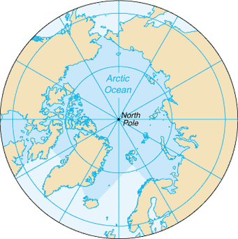
The Arctic Ocean is the ocean around the North Pole. The most northern parts of Eurasia and North America are around the Arctic Ocean. Thick pack ice and snow cover most of this ocean.
An icebreaker or a nuclear-powered submarine can use the Arctic Ocean to go between the Pacific and Atlantic oceans.The ocean's area is about 14.056 million sq km, which is the smallest of the world's four oceans, and it has 45,389 kilometres (28,203 mi) of coastline. The central surface covered by icepack about 3 metres (9.8 ft) in thickness.
The biology there is quite special. Some endangered animals there include walruses, whales and polar bears. The Arctic ocean is melting quicker then usual, as a result of global warming.The average depth of the Arctic Ocean is 1,038 metres (3,406 ft).The deepest point is in the Eurasian Basin, at 5,450 m (17,881 ft).
