
Rivers In Pakistan
Indus River
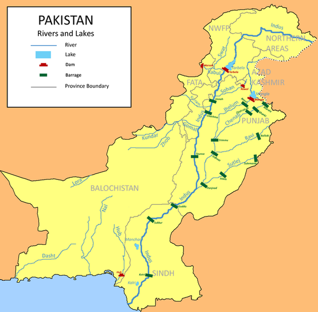
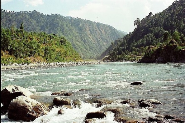
River Indus near Skardu, Pakistan
The Indus River (Sanskrit: सिन्धु Sindhu; Sindhi: سنڌو Sindhu; Pashto: اباسين Abāsin "The Father River"; Punjabi: سندھ Sindh; Hindko: سندھ Sindh; Avestan: Harahuti; Arabic: السند Al-Sind; Wylie: Sênggê Zangbo "Lion River"; Chinese: 森格藏布/狮泉河/印度河; pinyin: Sēngé Zàngbù/Shīquán Hé/Yìndù Hé; Greek: Ινδός Indós; Turki: Nilab) is a major river which flows through the Indian Subcontinent. Originating in the Tibetan plateau in the vicinity of Lake Mansarovar in Tibet Autonomous Region, the river runs a course through the Ladakh district of Jammu and Kashmir and then enters Northern Areas (Gilgit-Baltistan), flowing through the North in a southerly direction along the entire length of Pakistan, to merge into the Arabian Sea near port city of Karachi in Sindh. The total length of the river is 3,180 kilometers (1,976 miles) and it is Pakistan's longest river.
The river has a total drainage area exceeding 1,165,000 square kilometers (450,000 square miles). The river's estimated annual flow stands at around 207 cubic kilometers, making it the twenty-first largest river in the world in terms of annual flow. Beginning at the heights of the world with glaciers, the river feeds the ecosystem of temperate forests, plains and arid countryside. Together with the rivers Chenab, Ravi, Sutlej, Jhelum, Beas and two tributaries from the Khyber Pakhtunkhwa and Afghanistan, the Indus forms the Sapta Sindhu (Seven Rivers) delta of Pakistan.
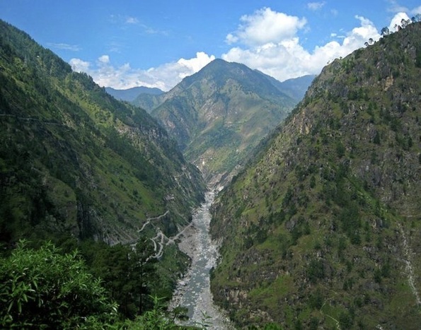
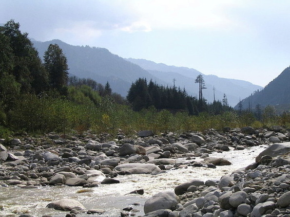
The ultimate source of the Indus is in Tibet; it begins at the confluence of the Sengge and Gar rivers that drain the Nganglong Kangri and Gangdise Shan mountain ranges. The Indus then flows northwest through Ladakh and Baltistan into Gilgit, just south of the Karakoram range. The Shyok River, Shigar and Gilgit streams carry glacial waters into the main river. It gradually bends to the south, coming out of the hills between Peshawar and Rawalpindi. The Indus passes gigantic gorges 4,500-5,200 meters (15,000-17,000 feet) deep near the Nanga Parbat massif. It flows swiftly across Hazara, and is dammed at the Tarbela Reservoir. The Kabul River joins it near Attock. The remainder of its route to the sea is in plains of the Punjab and Sindh, and the river becomes slow-flowing and highly braided. It is joined by Panjnad River at Mithankot. Beyond this confluence, the river, at one time, was named Satnad River (Sat = seven, Nadi = river), as the river was now carrying the waters of the Kabul River, the Indus River and the five Punjab rivers. Passing by Jamshoro, it ends in a large delta to the east of Thatta. The Indus is one of the few rivers in the world that exhibit a tidal bore. The Indus system is largely fed by the snows and glaciers of the Himalayas, Karakoram and the Hindu Kush ranges of Tibet, the state of Jammu and Kashmir and the Northern Areas of Pakistan respectively. The flow of the river is also determined by the seasons - it diminishes greatly in the winter, while flooding its banks in the monsoon months from July to September.
The name Indus is used in Arrian's Indica for the mighty river crossed by Alexander, based on Nearchus's contemporaneous account. "Indus" is a Hellenic derivative of the Iranian Hindu, in turn derived from Sindhu, the name of the Indus in the Rigveda. The Sanskrit Sindhu generically means river, stream, ocean, probably from a root sidh meaning to keep off; Sindhu is attested 176 times in the Rigveda, 95 times in the plural, more often used in the generic meaning. Already in the Rigveda, notably in the later hymns, the meaning of the word is narrowed to refer to the Indus river in particular, for example in the list of rivers of the Nadistuti sukta. This resulted in the anomaly of a river with masculine gender: all other Rigvedic rivers are female, not just grammatically, being imagined as goddesses and compared to cows and mares yielding milk and butter. The word "India" is derived from the Indus River. In ancient times, "India" initially referred to the region of Pakistan along the eastern banks of the Indus river, but by 300 BC, Greek writers like Megasthenes applied the term to the subcontinent which extends further eastward.
The river has a total drainage area exceeding 1,165,000 square kilometers (450,000 square miles). The river's estimated annual flow stands at around 207 cubic kilometers, making it the twenty-first largest river in the world in terms of annual flow. Beginning at the heights of the world with glaciers, the river feeds the ecosystem of temperate forests, plains and arid countryside. Together with the rivers Chenab, Ravi, Sutlej, Jhelum, Beas and two tributaries from the Khyber Pakhtunkhwa and Afghanistan, the Indus forms the Sapta Sindhu (Seven Rivers) delta of Pakistan.
The ultimate source of the Indus is in Tibet; it begins at the confluence of the Sengge and Gar rivers that drain the Nganglong Kangri and Gangdise Shan mountain ranges. The Indus then flows northwest through Ladakh and Baltistan into Gilgit, just south of the Karakoram range. The Shyok River, Shigar and Gilgit streams carry glacial waters into the main river. It gradually bends to the south, coming out of the hills between Peshawar and Rawalpindi. The Indus passes gigantic gorges 4,500-5,200 meters (15,000-17,000 feet) deep near the Nanga Parbat massif. It flows swiftly across Hazara, and is dammed at the Tarbela Reservoir. The Kabul River joins it near Attock. The remainder of its route to the sea is in plains of the Punjab and Sindh, and the river becomes slow-flowing and highly braided. It is joined by Panjnad River at Mithankot. Beyond this confluence, the river, at one time, was named Satnad River (Sat = seven, Nadi = river), as the river was now carrying the waters of the Kabul River, the Indus River and the five Punjab rivers. Passing by Jamshoro, it ends in a large delta to the east of Thatta. The Indus is one of the few rivers in the world that exhibit a tidal bore. The Indus system is largely fed by the snows and glaciers of the Himalayas, Karakoram and the Hindu Kush ranges of Tibet, the state of Jammu and Kashmir and the Northern Areas of Pakistan respectively. The flow of the river is also determined by the seasons - it diminishes greatly in the winter, while flooding its banks in the monsoon months from July to September.
The name Indus is used in Arrian's Indica for the mighty river crossed by Alexander, based on Nearchus's contemporaneous account. "Indus" is a Hellenic derivative of the Iranian Hindu, in turn derived from Sindhu, the name of the Indus in the Rigveda. The Sanskrit Sindhu generically means river, stream, ocean, probably from a root sidh meaning to keep off; Sindhu is attested 176 times in the Rigveda, 95 times in the plural, more often used in the generic meaning. Already in the Rigveda, notably in the later hymns, the meaning of the word is narrowed to refer to the Indus river in particular, for example in the list of rivers of the Nadistuti sukta. This resulted in the anomaly of a river with masculine gender: all other Rigvedic rivers are female, not just grammatically, being imagined as goddesses and compared to cows and mares yielding milk and butter. The word "India" is derived from the Indus River. In ancient times, "India" initially referred to the region of Pakistan along the eastern banks of the Indus river, but by 300 BC, Greek writers like Megasthenes applied the term to the subcontinent which extends further eastward.
Chenab River
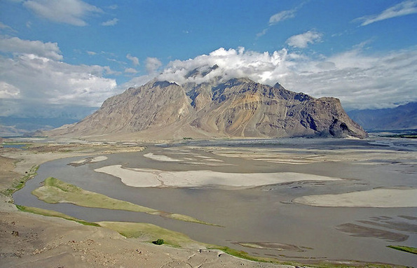
A view of Chenab River through Pangi valley in Himachal Pradesh
The Chenab River (Sanskrit: चंद्रभाग, Punjabi: ਚਨਾਬ, canab, Hindi: चनाब, Urdu: چناب, literally: 'Moon(Chan) چن River(aab)' آب) is formed by the confluence of the Chandra and Bhaga rivers at Tandi located in the upper Himalayas in the Lahul and Spiti District of Himachal Pradesh, India. In its upper reaches it is also known as the Chandrabhaga. It flows through the Jammu region of Jammu and Kashmir into the plains of the Punjab, forming the boundary between the Rechna and Jech interfluves (Doabs in Persian).
It is joined by the Jhelum River at Trimmu تریمو and then by the Ravi River Ahmedpur Sial احمدپور سیال. It then merges with the Sutlej River near Uch Sharif, Pakistan to form the Panjnad or the 'Five Rivers', the fifth being the Beas River which joins the Satluj near Ferozepur, India. The Chenab then joins the Indus at Mithankot, Pakistan. The total length of the Chenab is approximately 960 kilometres. The waters of the Chenab are allocated to Pakistan under the terms of the Indus Waters Treaty.
It is joined by the Jhelum River at Trimmu تریمو and then by the Ravi River Ahmedpur Sial احمدپور سیال. It then merges with the Sutlej River near Uch Sharif, Pakistan to form the Panjnad or the 'Five Rivers', the fifth being the Beas River which joins the Satluj near Ferozepur, India. The Chenab then joins the Indus at Mithankot, Pakistan. The total length of the Chenab is approximately 960 kilometres. The waters of the Chenab are allocated to Pakistan under the terms of the Indus Waters Treaty.
Jehlum River
Jehlum River or Jhelum River (Sanskrit: वितस्ता, Kashmiri: Vyeth, Hindi: झेलम, Punjabi: ਜੇਹਲਮ (Gurmukhi), Urdu: دریاۓ جہلم (Shahmukhi)) is a river that flows in India and Pakistan. It is the largest and most western of the five rivers of Punjab, and passes through Jhelum District. It is a tributary of the Chenab River and has a total length of about 505 miles (813 kilometers).
The river Jhelum rises from a spring at Verinag situated at the foot of the Pir Panjal in the south-eastern part of the valley of Kashmir. It flows through Srinagar and the Wular Lake before entering Pakistan from India-Occupied Kashmir through a deep narrow gorge. The Kishenganga Neelum River, the largest tributary of the Jhelum, joins it near Muzaffarabad, as does the next largest, the Kunhar River of the Kaghan valley. It also connects with Pakistan and Pakistan-administered Kashmir on Kohala Bridge east of Circle Bakote. It is then joined by the Poonch river, and flows into the Mangla reservoir in the Mirpur District. The Jhelum enters the Punjab in the Jhelum District. From there, it flows through the plains of Pakistan's Punjab, forming the boundary between the Chaj and Sindh Sagar Doabs. It ends in a confluence with the Chenab at Trimmu in District Jhang. The Chenab merges with the Sutlej to form the Panjnad River which joins the Indus River at Mithankot.
The river Jhelum rises from a spring at Verinag situated at the foot of the Pir Panjal in the south-eastern part of the valley of Kashmir. It flows through Srinagar and the Wular Lake before entering Pakistan from India-Occupied Kashmir through a deep narrow gorge. The Kishenganga Neelum River, the largest tributary of the Jhelum, joins it near Muzaffarabad, as does the next largest, the Kunhar River of the Kaghan valley. It also connects with Pakistan and Pakistan-administered Kashmir on Kohala Bridge east of Circle Bakote. It is then joined by the Poonch river, and flows into the Mangla reservoir in the Mirpur District. The Jhelum enters the Punjab in the Jhelum District. From there, it flows through the plains of Pakistan's Punjab, forming the boundary between the Chaj and Sindh Sagar Doabs. It ends in a confluence with the Chenab at Trimmu in District Jhang. The Chenab merges with the Sutlej to form the Panjnad River which joins the Indus River at Mithankot.
Ravi
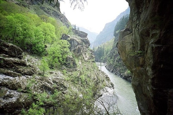
Ravi River, near Chamba
The Ravi (Hindi: रावी, Punjabi: راوی ਰਾਵੀ, Sanskrit: इरावती, परुष्णि, Urdu: راوی) is a trans-boundary river flowing through Northwestern India and Northeastern Pakistan. It is one of the six rivers of the Indus System in Punjab region (name of Punjab means "Five Rivers"). After the partition of India in August 1947, the waters of the Ravi River, along with five other rivers of the Indus system (Beas, Sutlej, Chenab, Jhelum and Indus), divided India and Pakistan under the Indus Water Treaty, which was facilitated by the World Bank.
Subsequently, Indus Basin Project has been developed in Pakistan and many Inter Basin Water Transfers, Irrigation, Hydropower and multipurpose projects have been built in India. The Ravi was known as Parushani or Iravati to Indians in Vedic times and Hydraotes to the Ancient Greeks.It is also called 'The river of Lahore' since that great city is located on its eastern bank.
It originates in the Himalayas in the Chamba district of Himachal Pradesh following a north-westerly course. It turns to the south-west, near Dalhousie, and then cuts a gorge in the Dhaola Dhar range entering the Punjab plain near Madhopur. It then flows along the Indo-Pak border for some distance before entering Pakistan and joining the Chenab River.
Sutlej River
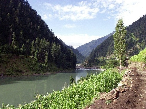
Sutlej River in Kinnaur,Himachal Pradesh,India
The Sutlej River (alternatively spelled as Satluj River) (Punjabi: ਸਤਲੁਜ, Sanskrit: शुतुद्रि, Śutudri, Urdu: ستلج, and Hindi: सतलज) is the longest of the five rivers that flow through the historic crossroad region of Punjab in northern India and Pakistan. It is located north of the Vindhya Range, south of the Hindu Kush segment of the Himalayas, and east of the Central Sulaiman Range in Pakistan.
The Sutlej is sometimes known as the Red River. It is the easternmost tributary of the Indus River. Its source is at Lake Rakshastal in Tibet near Mount Kailas, and it flows generally west and southwest entering India through the Shipki La pass in Himachal Pradesh. In Pakistan,it waters the ancient and historical former Bahawalpur state. The region to its south and east is arid, and is known as Cholistan a part of Bahawalpur Division. The Sutlej joins with the Beas River in Hari-Ke-Patan, Amritsar, Punjāb, India, and continues southwest into Pakistan to unite with the Chenab River, forming the Panjnad River near Bahawalpur.The Panjnad joins the Indus River at Mithankot. Indus then flows through a gorge near Sukkur, flows through the fertile plains region of Sindh, and terminates in the Arabian Sea near the port city of Karachi in Pakistan.
The Sutlej is sometimes known as the Red River. It is the easternmost tributary of the Indus River. Its source is at Lake Rakshastal in Tibet near Mount Kailas, and it flows generally west and southwest entering India through the Shipki La pass in Himachal Pradesh. In Pakistan,it waters the ancient and historical former Bahawalpur state. The region to its south and east is arid, and is known as Cholistan a part of Bahawalpur Division. The Sutlej joins with the Beas River in Hari-Ke-Patan, Amritsar, Punjāb, India, and continues southwest into Pakistan to unite with the Chenab River, forming the Panjnad River near Bahawalpur.The Panjnad joins the Indus River at Mithankot. Indus then flows through a gorge near Sukkur, flows through the fertile plains region of Sindh, and terminates in the Arabian Sea near the port city of Karachi in Pakistan.
Beas River
The Beas River (Hindi: ब्यास, Punjabi: ਬਿਆਸ, Urdu: بیاس, Sanskrit: विपाशा) is the second easternmost of the rivers of the Punjab, a tributary of Indus River. The river rises in the Himalayas in central Himachal Pradesh, India, and flows for some 470 km (290 miles) to the Sutlej River in South Punjab of India.
The river begins at the Rohtang Pass in the state of Himachal Pradesh, merging with the Sutlej at Harike Pattan south of Amritsar in Punjab, India via Mandi. The Sutlej continues into Pakistani Punjab and joins the Chenab River at Uch near Bahawalpur to form the Panjnad River; the latter in turn joins the Indus River at Mithankot. The waters of the Ravi, Beas (Vipasha) and Sutlej (also known as Shathadru) rivers are allocated to India under the Indus Waters Treaty between India and Pakistan.
The river begins at the Rohtang Pass in the state of Himachal Pradesh, merging with the Sutlej at Harike Pattan south of Amritsar in Punjab, India via Mandi. The Sutlej continues into Pakistani Punjab and joins the Chenab River at Uch near Bahawalpur to form the Panjnad River; the latter in turn joins the Indus River at Mithankot. The waters of the Ravi, Beas (Vipasha) and Sutlej (also known as Shathadru) rivers are allocated to India under the Indus Waters Treaty between India and Pakistan.
