
New Seven Wonders of Nature
New Seven Wonders of Nature (2007–2011) was an initiative started in 2007 to create a list of seven natural wonders chosen by people through a global poll. It was led by Canadian-Swiss Bernard Weber and organized by the New7Wonders Foundation, a Swiss-based foundation. The initiative followed the New Seven Wonders of the World, and attracted 100 million votes from around the world before voting finished on November 11, 2011.
From over 440 participants representing over 220 countries and through a national qualification and race to become one of the Top 77, as well as the recommendations of the Panel of Experts led by Prof. Federico Mayor, the list of 28 "Official Finalist Candidates" was determined. Voting until November 2011, during which time the New7Wonders World Tour planned to visit each of the finalists to allow them to present themselves to the voters across the globe. New7Wonders of Nature, based on the results announced at the N7W headquarters in Zurich on November 11, 2011.
From over 440 participants representing over 220 countries and through a national qualification and race to become one of the Top 77, as well as the recommendations of the Panel of Experts led by Prof. Federico Mayor, the list of 28 "Official Finalist Candidates" was determined. Voting until November 2011, during which time the New7Wonders World Tour planned to visit each of the finalists to allow them to present themselves to the voters across the globe. New7Wonders of Nature, based on the results announced at the N7W headquarters in Zurich on November 11, 2011.
Amazon River and Rainforest
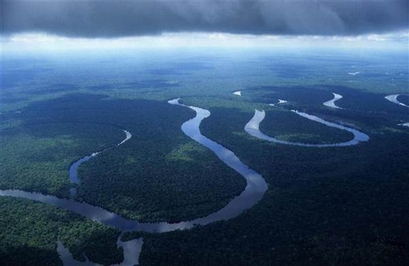
The Amazon River in South America is the second longest river in the world and by far the largest by waterflow with an average discharge greater than the next seven largest rivers combined (not including Madeira and Rio Negro, which are tributaries of the Amazon). The Amazon, which has the largest drainage basin in the world, about 7,050,000 square kilometres (2,720,000 sq mi), accounts for approximately one-fifth of the world's total river flow.
In its upper stretches, above the confluence of the Rio Negro, the Amazon is called Solimões in Brazil; however, in Peru, Colombia and Ecuador, as well as the rest of the Spanish-speaking world, the river is generally called the Amazon downstream from the confluence of the Marañón and Ucayali rivers in Peru. The Ucayali-Apurímac river system is considered the main source of the Amazon.
The width of the Amazon varies between 1.6 and 10 kilometres (1.0 and 6.2 mi) at low stage, but expands during the wet season to 48 kilometres (30 mi) or more. The river enters the Atlantic Ocean in a broad estuary about 240 kilometres (150 mi) wide. The mouth of the main stem is 80 kilometres (50 mi). Because of its vast dimensions, it is sometimes called The River Sea. The first bridge in the Amazon river system (over the Rio Negro) opened on 10 October 2010. It is just outside Manaus.
While, The Amazon Rainforest also known in English as Amazonia or the Amazon Jungle, is a moist broadleaf forest that covers most of the Amazon Basin of South America. This basin encompasses seven million square kilometers (1.7 billion acres), of which five and a half million square kilometers (1.4 billion acres) are covered by the rainforest. This region includes territory belonging to nine nations. The majority of the forest is contained within Brazil, with 60% of the rainforest, followed by Peru with 13%, Colombia with 10%, and with minor amounts in, Venezuela, Ecuador, Bolivia, Guyana, Suriname and French Guiana. States or departments in four nations contain "Amazonas" in their names. The Amazon represents over half of the planet's remaining rainforests, and it comprises the largest and most species-rich tract of tropical rainforest in the world.
Wet tropical forests are the most species-rich biome, and tropical forests in the Americas have more species African and Asian wet forests. As the largest area of tropical rainforest in the Americas, Amazonian rainforests have more biodiversity than anywhere else in the Americas (which means that they have many different species).
The region is home to ~2.5 million insect species, tens of thousands of species of plants, and some 2000 species of birds and mammals. The diversity of plant species is the highest on earth with some experts estimating that one square kilometre may contain over 75,000 types of trees and 150,000 species of higher plants. One square kilometre of Amazon rainforest can have about 90,000 tons of living plants. This is the largest collection of living plants and animal species in the world. One in five of all the birds in the world live in the rainforests of the Amazon. To date, an estimated 438,000 species of plants of economic and social interest have been registered in the region with many more remaining to be discovered or cataloged. (Note: Brazil has one of the most advanced laws to avoid biopiracy, but enforcing these laws is a problem.)
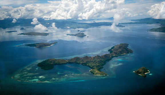
Ha Long Bay
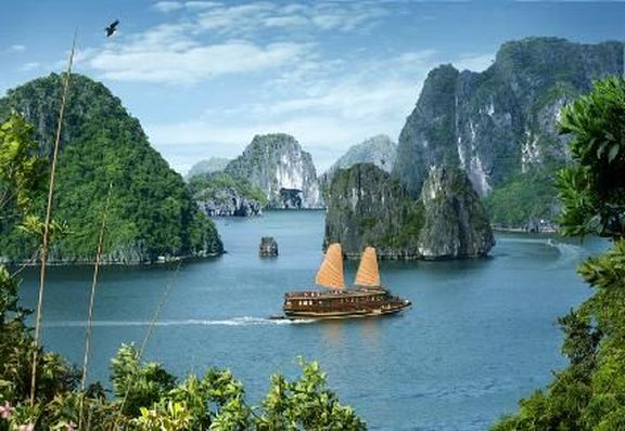
Ha Long Bay (literally: "Descending dragon bay") is a UNESCO World Heritage Site, and a popular travel destination, located in Quang Ninh province, Vietnam. Administratively, the bay belongs to Hạ Long City, Cẩm Phả town, and part of Van Don district. The bay features thousands of limestone karsts and isles in various sizes and shapes. Ha Long Bay is a center of a larger zone which includes Bái Tử Long bay to the northeast, and Cát Bà islands to the southwest. These larger zones share similar geological, geographical, geomorphological, climate, and cultural characters.
Ha Long Bay has an area of around 1,553 km2, including 1,960–2,000 islets, most of which are limestone. The core of the bay has an area of 334 km2 with a high density of 775 islets. The limestone in this bay has gone through 500 million years of formation in different conditions and environments. The evolution of the karst in this bay has taken 20 million years under the impact of the tropical wet climate. The geo-diversity of the environment in the area has created biodiversity, including a tropical evergreen biosystem, oceanic and sea shore biosystem. Ha Long Bay is home to 200 species of fish and 450 different kinds of mollusks, 14 endemic floral species and 60 endemic faunal species.
Historical research surveys have shown the presence of prehistorical human beings in this area tens of thousands years ago. The successive ancient cultures are the Soi Nhụ culture around 18,000–7000 BC, the Cái Bèo culture 7000–5000 BC and the Ha Long culture 5,000–3,500 years ago. Ha Long Bay also marked important events in the history of Vietnam with many artifacts found in Bài Thơ Mout, Đầu Gỗ Cave, Bãi Cháy.
In 1994, the core zone of Ha Long Bay was listed by UNESCO as a World Heritage Site according to criterion vii, and listed for a second time according to criterion viii. The climate of the bay is tropical, wet, sea islands, with two seasons: hot and moist summer, and dry and cold winter. The average temperature is from 15°C- 25°C, and annual rainfall is between 2000mm and 2200mm. Hạ Long Bay has the typical diurnal tide system (tide amplitude ranges from 3.5-4m). The salinity is from 31 to 34.5MT in the dry season and lower in the rainy season.
Iguazu Falls
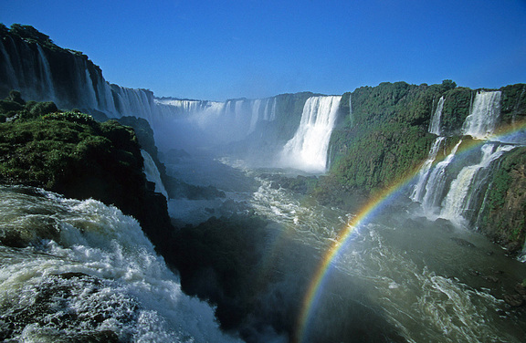
Iguazu Falls, Iguassu Falls or Iguaçu Falls are waterfalls of the Iguazu River on the border of Brazilian State Paraná and Argentine Province Misiones. The falls divide the river into the upper and lower Iguazu. The Iguazu River originates near the city of Curitiba. It flows through Brazil for most of its course. Below its confluence with the San Antonio River, the Iguazu River forms the boundary between Argentina and Brazil.
The name "Iguazu" comes from the Guarani or Tupi words "y", meaning "water", and "ûasú ", meaning "big". Legend has it that a god planned to marry a beautiful woman named Naipí, who fled with her mortal lover Tarobá in a canoe. In rage, the god sliced the river, creating the waterfalls and condemning the lovers to an eternal fall. The first European to find the falls was the Spanish conquistador Álvar Núñez Cabeza de Vaca in 1541.
Iguazu Falls is located where the Iguazu River tumbles over the edge of the Paraná Plateau, 23 kilometres (14 mi) upriver from the Iguazu's confluence with the Paraná River. Numerous islands along the 2.7-kilometre-long (1.7 mi) edge divide the falls into numerous separate waterfalls and cataracts, varying between 60 to 82 metres (197 to 269 ft) high. The number of these smaller waterfalls fluctuates from 150 to 300, depending on the water level. About half of the river's flow falls into a long and narrow chasm called the Devil's Throat (Garganta del Diablo in Spanish or Garganta do Diabo in Portuguese). The Devil's Throat is U-shaped, 82 meters high, 150 m wide, and 700 m long (269×490×2,300 ft). Placenames have been given also to many other smaller falls, such as San Martin Falls, Bossetti Falls and many others.
About 900 meters (2,950 ft) of the 2.7-kilometre (1.7 mi) length does not have water flowing over it. The edge of the basalt cap recedes by 3 mm (0.1 in) per year. The water of the lower Iguazu collects in a canyon that drains in the Paraná River, a short distance downstream from the Itaipu Dam. The junction of the water flows marks the border between Brazil, Argentina, and Paraguay. There are points in the cities of Foz do Iguaçu, Brazil, Puerto Iguazú, Argentina, and Ciudad del Este, Paraguay, which have access to the Iguazu River, where the borders of all three nations can be seen, a popular tourist attraction for visitors to the three cities.
Puerto Princesa Subterranean River National Park
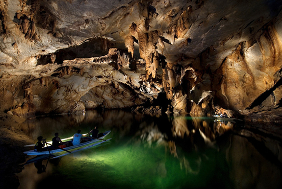
The Puerto Princesa Subterranean River National Park is located about 50 kilometres (30 mi) north of the city centre of Puerto Princesa, Palawan, Philippines. The river is also called Puerto Princesa Underground River. The national park is located in the Saint Paul Mountain Range on the northern coast of the island. It is bordered by St. Paul Bay to the north and the Babuyan River to the east. The City Government of Puerto Princesa has managed the National Park since 1992. The park is also known as St. Paul's Subterranean River National Park, or St. Paul Underground River. The entrance to the Subterranean River is a short hike from the town of Sabang.In 2010, a group of environmentalists and geologists discovered that the underground river has a second floor, which means that there are small waterfalls inside the cave.They also found a huge cave dome, the underground river, incredible rock formations, large bats, a deep water hole in the river, more river channels, another deep cave, marine creatures, and more.
The park has a limestone karst mountain landscape. The main attraction here is St. Pauls Underground River Cave - a more than 24 km long cave, which contains an 8.2-kilometer-long underground section of Cabayugan River. A distinguishing feature of the river is that it winds through the cave before flowing directly into the South China Sea, and is navigable with a boat up to 4 kilometres in from the sea. The cave includes major formations of stalactites and stalagmites, and several large chambers, including the 360-meter-long Italian's Chamber with approximate 2.5 million square meters volume - one of the largest cave rooms in the world. The lower portion of the river up to 6 km from the sea, is subject to tidal influences. Until the 2007 discovery of an underground river in Mexico's Yucatán Peninsula, the Puerto Princesa Subterranean River was reputed to be the world's longest underground river. Deeper areas of the underground river are almost impossible to expedite due to oxygen deprivation.
The area also represents a habitat for biodiversity conservation. The site contains a full mountain-to-the-sea ecosystem and has some of the most important forests in Asia. It was inscribed by UNESCO as a World Heritage Site on December 4, 1999.
The Park has a range of forest formations representing eight of the thirteen forest types found in tropical Asia, namely forest over ultramafic soils, forest over limestone soils, montane forest, freshwater swamp forest, lowland evergreen tropical rainforest, riverine forest, beach forest, and mangrove forest. Researchers have identified more than 800 plant species from 300 genera and 100 families. Birds comprise the largest group of vertebrates found in the park. Of the 252 bird species known to occur in Palawan, a total of 165 species of birds were recorded in the park. This represents 67% of the total birds and all of the 15 endemic bird species of Palawan. There are also some 30 mammal species that have been recorded (Madulid, 1998). Most often observed in the forest canopy and along the shoreline feeding during low tide is the long-tailed macaque. 19 species of reptiles have been identified, eight of which are endemic (Madulid, 1998)
Komodo National Park
The Komodo National Park is a national park in Indonesia. It is on several islands in the Lesser Sunda Islands. The park is in the area between the East Nusa Tenggara and West Nusa Tenggara provinces. The park includes three larger islands: Komodo, Padar and Rincah. It also includes 26 smaller ones for a total area of 1,733 km² (603 km² of it land). It also includes ocean areas such as the Sape Straights. The islands of the national park are volcanic. The land is generally rugged, with some rounded hills to 735m. The climate is one of the driest of Indonesia. Each year between 800mm and 1000mm of rain falls in the park area. Temperatures in the dry season from May to October are around 40°C.
The national park was founded in 1980 to protect the Komodo dragon. This animal is the world's largest lizard. Later it began protecting other species, including some in the ocean. In 1991 the national park was named a UNESCO World Heritage Site.
The Park is hot and dry. There are many savannah plants that make it a good place for the Komodo dragon.
Cloud forests are in only a few areas above 500 metres. These forests are good places for some local plants. There are mangrove forests in some of the quiet bays of the three larger islands.
Large and complex coral reefs are along the north-east coast of Komodo. The park has many animals that live in the ocean, including whale sharks, ocean sunfish, manta rays, eagle rays, pygmy seahorse, false pipefish, clown frogfish, nudibranchs, blue-ringed octopus, sponges, tunicates, and coral.
There are presently almost 4,000 inhabitants living within the park spread out over four settlements (Komodo, Rinca, Kerora, and Papagaran). All villages existed prior to 1980 before the area was declared a national park. The total population currently living in the Park is 3,267 people, while 16,816 people live in the area immediately surrounding the Park. The population are primarily adherents of Islam but there are also Christian and Hindu congregations.
Table Mountain
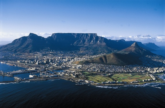
Table Mountain is a flat-topped mountain overlooking the city of Cape Town in South Africa. It is a significant tourist attraction, featured in the flag of Cape Town and other local government insignia. Many visitors use the Table Mountain Aerial Cableway or hike to the top. The mountain forms part of the Table Mountain National Park.
The main feature of Table Mountain is the level plateau approximately 3 kilometres (2 mi) from side to side, edged by impressive cliffs. The plateau, flanked by Devil's Peak to the east and by Lion's Head to the west, forms a dramatic backdrop to Cape Town. This broad sweep of mountainous heights, together with Signal Hill, forms the natural amphitheatre of the City Bowl and Table Bay harbour. The highest point on Table Mountain is towards the eastern end of the plateau and is marked by Maclear's Beacon, a stone cairn built in 1865 by Sir Thomas Maclear for trigonometrical survey. It is 1,086 metres (3,563 ft) above sea level, about 19 metres (62 ft) higher than the cable station at the western end of the plateau. The cliffs of the main plateau are split by Platteklip Gorge ("Flat Stone Gorge"), which provides an easy and direct ascent to the summit and was the route taken by António de Saldanha on the first recorded ascent of the mountain in 1503.
Table Mountain has an unusually rich biodiversity. The mountain's vegetation types form part of the Cape Floral Region protected areas. These protected areas are a World Heritage Site, and an estimated 2,200 species of plants are confined to Table Mountain - more than exist in the whole of the United Kingdom. The most common mammal on the mountain is the dassie, or rock hyrax. They especially cluster around the upper cable station, near areas where tourists may discard or (illegally) supply food. There are also porcupines, mongooses, snakes and tortoises. The last lion in the area was shot circa 1802. Leopards persisted on the mountain until perhaps the 1920s but are now extinct locally. Two smaller, secretive, nocturnal carnivores, the rooikat (caracal) and the vaalboskat (also called the vaalkat or African Wild Cat) were once common on the mountain. The rooikat continues to be seen on rare occasions by mountaineers but the status of the vaalboskat is uncertain.
Jeju-do
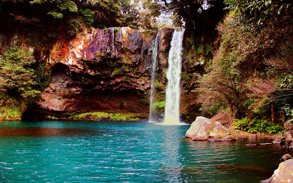
Cheonjiyeon Waterfall on Jeju Island
Jeju-do (Transliterated Korean for Jeju Province, short form of Jeju Special Self-governing Province or Cheju Island) is the largest island and smallest province of South Korea. Its capital is the city of Jeju.
Jejudo is a volcanic island, 130 km from the southern coast of Korea. The island has a surface area of 1,846 sqkm. A central feature of Jeju is Hallasan, the tallest mountain in South Korea and a dormant volcano, which rises 1,950 m above sea level. 360 satellite volcanoes are around the main volcano.
The Natural World Heritage Site Jeju Volcanic Island and Lava Tubes is also present on the island.
