
Islamabad
 Faisal mosque  Parliament of Pakistan 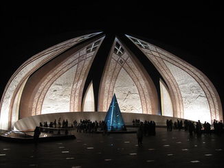 Pakistan Monument |
Quick Facts
|
Islamabad (Urdu: Pashto: اسلام آباد) Islām ābād (Meaning "Abode of Islam" or Abode of Peace) is the capital of Pakistan, and is the tenth largest city in Pakistan with an estimated population of 1.74 million in 2009.The Rawalpindi/Islamabad Metropolitan Area is the third largest in Pakistan, with a population of over 4.5 million inhabitants.
Islamabad is located in the Pothohar Plateau in the north of the country, within the Islamabad Capital Territory. The region has historically been a part of the crossroads of Punjab and North-West Frontier Province, Margalla pass being a gateway to the North-West Frontier Province.The city was built during the 1960s to replace Karachi as Pakistan's capital. However, the capital was not moved directly from Karachi to Islamabad. It was first shifted to Rawalpindi and then to Islamabad after all the developmental works were finished.
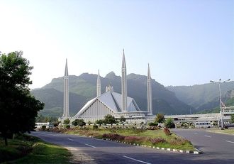
Islamabad is one of the greenest and most well-planned cities of South Asia.According to a survey, Islamabad is considered the cleanest city in Pakistan.The city is well-organized and divided into different sectors and zones. Islamabad was ranked as a Gamma world city in 2008.The city is home to Faisal Mosque, the largest mosque in South Asia and the sixth largest mosque in the World. Islamabad has the highest literacy rate in Pakistan.The top ranked university in Pakistan, Quaid-i-Azam University, is located in Islamabad. The top two engineering universities in Pakistan, Pakistan Institute of Engineering & Applied Sciences and National University of Sciences and Technology are also located here.Allama Iqbal Open University in Islamabad is the world's second largest university by enrollment.
Islamabad is located in the Pothohar Plateau in the north of the country, within the Islamabad Capital Territory. The region has historically been a part of the crossroads of Punjab and North-West Frontier Province, Margalla pass being a gateway to the North-West Frontier Province.The city was built during the 1960s to replace Karachi as Pakistan's capital. However, the capital was not moved directly from Karachi to Islamabad. It was first shifted to Rawalpindi and then to Islamabad after all the developmental works were finished.
Islamabad is one of the greenest and most well-planned cities of South Asia.According to a survey, Islamabad is considered the cleanest city in Pakistan.The city is well-organized and divided into different sectors and zones. Islamabad was ranked as a Gamma world city in 2008.The city is home to Faisal Mosque, the largest mosque in South Asia and the sixth largest mosque in the World. Islamabad has the highest literacy rate in Pakistan.The top ranked university in Pakistan, Quaid-i-Azam University, is located in Islamabad. The top two engineering universities in Pakistan, Pakistan Institute of Engineering & Applied Sciences and National University of Sciences and Technology are also located here.Allama Iqbal Open University in Islamabad is the world's second largest university by enrollment.
History Of Islamabad
(i) Early history
15th century Pharwala Fort beside the Swaan River
The region is preceded by thousands of years of history. Islamabad Capital Territory, located in the Pothohar Plateau, is regarded to be one of the earliest sites of human settlement in Asia.The plateau has revealed evidence of a prehistoric culture. It is known that a Buddhist town once existed in the region.Relics and human skulls have been found dating back to 5000 B.C. that show this region was home to Neolithic people who used the banks of Swaan River as their settlement.The Neolithic people developed small communities in the region at around 3000 BC, leading to the early roots of civilization here.
Situated at one end of the Indus Valley Civilization, this area was the first habitation of the Aryan community from Central Asia.The civilization flourished here between the 23rd and 18th centuries BC. Some of the earliest Stone Age artifacts in the world have been found on the plateau, dating from 500,000 to 100,000 years. The crude stones recovered from the terraces of the Soan carry the account of human grind and endeavours in this part of the world from the inter-glacial period.Items of pottery and utensils dating back to prehistory have also been found.
Islamabad was one of the routes though which the armies from the north and northwest passed to invade the Indian Subcontinent. Many great armies such as those of Alexander the Great, Genghis Khan, Timur and Ahmad Shah Durrani have used this route on their way to Indian Subcontinent.Modern Islamabad is based on the old settlement known as Saidpur. The region later became a Sikh town and became an important trading centre. The British seized the region from the Sikhs in 1849 and built Asia’s largest cantonment in the region.
(ii) Construction and Development

Muhammad Ayub Khan
When Pakistan gained Independence in 1947, Karachi was its first capital. However, in 1960, Islamabad was constructed as a forward capital due to certain reasons. Traditionally, the development was focused on the colonial centre of Karachi and President Ayub Khan (First military ruler of Pakistan, serving as the second President of Pakistan) wanted it to be equally distributed. Moreover, Karachi was located at one end of the country making it vulnerable to attacks from the Arabian Sea and a capital which was easily accessible from all parts of the country was needed. The new selected location of Islamabad was closer to GHQ in Rawalpindi and the disputed territory of Kashmir in the North.
In 1958, a commission was constituted to select a suitable site for the national capital with particular emphasis on location, climate, logistics, and defence requirements along with other attributes. After extensive study, research, and thorough review of various sites, the commission recommended the area northeast of Rawalpindi. A Greek firm of architect Konstantinos Apostolos Doxiadis designed the master plan of the city which was triangular in shape, based on a Grid plan, with its apex towards the Margalla Hills.
In 1958, a commission was constituted to select a suitable site for the national capital with particular emphasis on location, climate, logistics, and defence requirements along with other attributes. After extensive study, research, and thorough review of various sites, the commission recommended the area northeast of Rawalpindi. A Greek firm of architect Konstantinos Apostolos Doxiadis designed the master plan of the city which was triangular in shape, based on a Grid plan, with its apex towards the Margalla Hills.
Geography
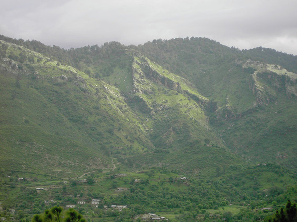
Margalla Hills
Islamabad is located at 33.43°N 73.04°E at the edge of the Pothohar Plateau on the foot of the Margalla Hills in Islamabad Capital Territory. It is situated at an elevation of 507 metres (1,663 ft).The modern capital and the ancient Gakhar city of Rawalpindi stand side by side and are therefore commonly referred to as the Twin Cities. On the east of the city lies Murree and Kotli Sattian. On the north lies the Haripur District of North-West Frontier Province. Kahuta lies on the northeast, Taxila, Wah Cantt, and Attock District on the northwest, Gujar Khan, Kallar Syedian, Rawat, and Mandrah on the northeast, and Rawalpindi on the southwest. Islamabad is located 120 kilometres (75 mi) SSW of Muzaffarabad, 185 kilometres (115 mi) east of Peshawar, 295 kilometres (183 mi) NNE of Lahore, and 300 kilometres (190 mi) WSW of Srinagar; the capital of Indian Kashmir.
The capital area of the Islamabad city is 906 square kilometres (350 sq mi). A further 2,717 square kilometres (1,049 sq mi) area is known as the Specified Area, with the Margala Hills in the north and northeast. The southern portion of the city is an undulating plain. It is drained by the Kurang River, on which the Rawal Dam is located.
Islamabad's micro-climate is regulated by three artificial reservoirs; Rawal, Simli, and Khanpur Dam. Khanpur Dam is located on the Haro River near the town of Khanpur (NWFP), about 40 kilometres (25 mi) from Islamabad. Simli Dam is located around 30 kilometres (19 mi) north of Islamabad. 220 acres (89 ha) of the city is covered with Margalla Hill National Park. Along the Islamabad Highway, Loi Bher Forest is situated, covering an area of 1,087 acres (440 ha).
Climate
Islamabad features an atypical version of a humid subtropical climate, with long and very hot summers accompanied by a monsoon season followed by short and mild winters.
The hottest months are from May to July, where average highs routinely exceed 38 °C (100.4 °F). The monsoon season occurs July through September, with heavy rainfalls and evening thunderstorms. Winters occur from October to March with temperatures variable by location, with mild temperatures in the city and sparse snowfall over the hills.
The weather ranges from a minimum of 3.9 °C (39.0 °F) in January to a maximum of 46.1 °C (115.0 °F) in June.The average low is 2 °C (35.6 °F) in January, while the average high is 40 °C (104.0 °F) in June.The highest temperature recorded was 48 °C (118.4 °F) in June, while the lowest temperature was −4 °C (24.8 °F) in January. On 23 July 2001, Islamabad received a record breaking 620 mm of rainfall in 10 hours. It was the heaviest rainfall in Islamabad in 100 years.
Cityscape
(i) Civic administration
 |
Islamabad Capital territory is divided into eight zones; Administrative Zone, Commercial District, Educational Sector, Industrial Sector, Diplomatic Enclave, Residential Areas, and Rural Areas and Green Area.
|
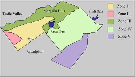
Islamabad city is divided into five major zones, Zone I, Zone II, Zone III, Zone IV, and Zone V. Out of these, Zone IV is the largest in area. Zone I comprises mainly of all the developed residential sectors in Islamabad while Zone II comprises the under-developed residential sectors. Each residential sector is identified by an alphabet and a number, and covers an area of approximately 2 km × 2 km (11⁄4 mi × 11⁄4 mi). The sectors are named from A to I, and each sector is divided into four sub-sectors, named numerically.Series A, B, and C are still underdeveloped. D series have 7 sectors (D-11 to D-17) in which only sector D-12 is complete. This series is located right under the foot of Margalla Hills.The E Sectors are named from E-7 to E-17 and many foreigners and diplomatic personnels are housed in these sectors.In the revised Master Plan of the city, CDA has decided to develop a park on the patterns of F-9 park in sector E-14. Sectors E-8 and E-9 contain the campuses of three Defense universities; Bahria University, Air University, and National Defence University.
The F and G series contains the most developed sectors. F series contains sectors F-5 to F-17 where the later sectors are still under-developed. F-5 is an important sector for the software industry in Islamabad, as both of the two software technology parks are located here. The entire F-9 sector is covered with Fatima Jinnah Park.
The Centaurus complex will be one of the major landmarks of the F-8 sector.G sectors are numbered G-5 through G-17.Some important places include the Jinnah Convention Center and Serena Hotel in G-5, the Red Mosque in G-6, and Pakistan Institute of Medical Sciences in G-8 which is the largest medical complex in the capital. The H sectors are numbered H-8 through H-17.The H sectors are mostly dedicated to educational and health institutions.
National University of Science and Technology covers a major portion of sector H-12. The I sectors are numbered from I-8 to I-18. Except for I-8 which is a well developed residential area, these sectors are primarily a part of the industrial zone. Currently, only two sub-sectors of I-9 and one sub-sector of I-10 is used as industrial areas. CDA is planning to set up Islamabad Railway Station in Sector I-18 and Industrial City in sector I-17.
Zone III constitutes primarily of the Margalla Hills and Margalla Hills National Park. Rawal Lake is also present in this zone. Zone IV and V comprises Islamabad Park and rural areas of the city. Soan River flows into the city through Zone V.The main administrative authority of the city is Capital Development Authority (CDA) which oversees the planning, development, construction, and administration of the city.
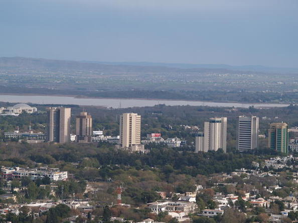
(ii) Islamabad/Rawalpindi Metropolitan Area
Islamabad Blue Area
In 1960, when the master plan for Islamabad was designed, it was planned that Islamabad and Rawalpindi along with the adjoining areas will be integrated to form a large metropolitan area called Islamabad/Rawalpindi Metropolitan Area. The area would consist of the developing Islamabad, the old city of Rawalpindi, and the Islamabad National Park. Initially, it was proposed that the three areas will be connected by four major highways; Murree Highway, Islamabad Highway, Soan Highway, and Capital Highway. However, to date only two highways have been constructed; Murree Highway (now called Kashmir Highway) and Islamabad Highway.
Presently, the area comprises Islamabad Capital Territory (Islamabad, Islamabad National Park, and Islamabad Rural Area) and Rawalpindi. Islamabad is the hub all the governmental activities while Rawalpindi is the centre of all industrial, commercial, and military activities. The two cities are considered sister cities and are highly dependent for the development of the metropolitan.
Islamabad/Rawalpindi Metropolitan Area is the third largest in Pakistan, with a population of over 4.5 million.The area is drained by two major rivers; Kurang River and Soan River. Three dams; Rawal Lake, Simly Dam, and Khanpur Dam are located in the region, providing water to the local population.
(iii) Architecture
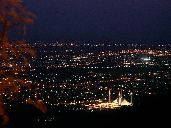
Night view of the Faisal Mosque from Margalla Hills
Islamabad's architecture walks a tightrope between modernity and old Islamic and regional traditions. The Saudi-Pak Tower is a good example of the integration of modern architecture with traditional styles. The beige-coloured edifice is trimmed with blue tile works in Islamic tradition, and is one of Islamabad's tallest buildings. Other examples of intertwined Islamic and modern architecture include Pakistan Monument and Faisal Mosque.
The murals on the inside of large petals of Pakistan Monument are based on Islamic architecture.The design of Shah Faisal Mosque is a fusion of contemporary lines with the more traditional look of an Arab Bedouin's tent with large triangular prayer hall and four minarets. The mosque's architecture is a departure from the long history of South Asian Muslim architecture with a lack of dome structure in Faisal Mosque. However, in some ways it makes a bridge between Arabic, Turkish, and Mughal architectural traditions.
The Centaurus is one of the examples of modern architecture under construction in Islamabad. The seven star hotel is designed by WS Atkins PLC.The newly built Islamabad Stock Exchange Towers is another example of modern architecture in the city.
Demographics
Islamabad had population of 1.21 million in 2009. The current population, in 2011, is estimated to be around 1.70 million.
Urdu, the national and first official language of the country, is predominantly spoken within the city due to the ethnic mix of populations. English, the second official language, is also commonly understood. Other languages include Punjabi, Pashto and Pothohari. The mother tongue of the majority of the population is Punjabi, at 72%. 10% of the population are native Sindhi speakers, 10% are native Pushto speakers, and 8% other languages. The total migrant population of the city is 397,731, with the majority from Punjab (241,977). Around 76,614 of the migrated population came from Khyber Pakhtunkhwa, 75,143 from Sindh, 24,438 from Pakistan-administered Kashmir, and 21,372 from other countries. Smaller populations emigrated from Federally Administered Tribal Areas, Balochistan, and Gilgit-Baltistan.
Islam is the largest religion in the city, with 95.53% of the population Muslim. In rural areas this percentage is 98.80%, while in urban areas the percentage of Muslims is 93.83%. The second largest religion is Christianity, with 4.07% of the population, 0.94% in rural areas and 5.70% in the city. Hinduism accounts for 0.02% of the population, and other minorities 0.03%.The majority of the population lies in the age group of 15–64 years, around 59.38%. Only 2.73% of the population is above 65 years of age; 37.90% is below the age of 15. Islamabad has the highest literacy rate in Pakistan, at 87%. 9.8% of the population has done intermediate education (equivalent to grades 11 and 12). 10.26% have a bachelor or equivalent degree while 5.2% have a master or equivalent degree. The labour force of Islamabad is 185,213 and the unemployment rate is 15.70%.
Infrastructure
(i) Education
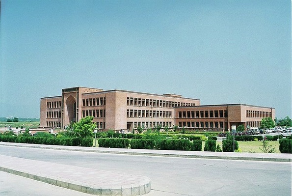
International Islamic University
Islamabad boasts the highest literacy rate in Pakistan at 87% (2007). A large number of public and private sector educational institutes are present here. The higher education institutes in the capital are either federally chartered or administered by private organisations and almost all of them are recognised by the Higher Education Commission of Pakistan. High schools and colleges are either affiliated with the Federal Board of Intermediate and Secondary Education or with the UK universities education boards, O/A Levels, or IGCSE. According to Academy of Educational Planning And Management's report, in 2006 there were a total of 904 recognised institutions in Islamabad (30 pre-primary, 2 religious, 384 primary, 157 middle, 291 high, 15 intermediate, and 25 degree colleges). There are seven teacher training institutes in Islamabad with a total enrolment of 581,068 students and 491 faculty.
The Gender Parity Index in Islamabad is 0.93 compared to 0.95 for Pakistan. There are 178 boys only institutes, 175 girls, and 551 mixed institutes in the capital territory. Total enrolment of students in all categories is 273,583; 139,961 for boys and 133,622 for girls.
There are 17 recognised universities in Islamabad with a total enrolment of 279,820 students and 25,653 teachers. The world's second largest university by enrolment, Allama Iqbal Open University, is located in Islamabad. The two top engineering universities in Pakistan, Pakistan Institute of Engineering & Applied Sciences and National University of Sciences and Technology also have their headquarters in the capital. Quaid-i-Azam University in Islamabad is the top ranked university in Pakistan in the general category. Other universities include Iqra University Islamabad, Air University, Bahria University, National University of Computer and Emerging Sciences, COMSATS, Hamdard University, National Defence University, Shifa College of Medicine, National University of Modern Languages, International Islamic University, Center for Advanced Studies in Engineering, and Muhammad Ali Jinnah University.In 2006–2007, the Federal Government spent a total of 54,523.637 million Rs. on the education sector out of which 25,830.670 million was the developmental fund. This amount is 25.18% of the total educational budget spend in that year, which was 216,518.059 million Rs. The public expenditure on education as a percentage of total government spending that year was 14.09%.
(ii) Health care
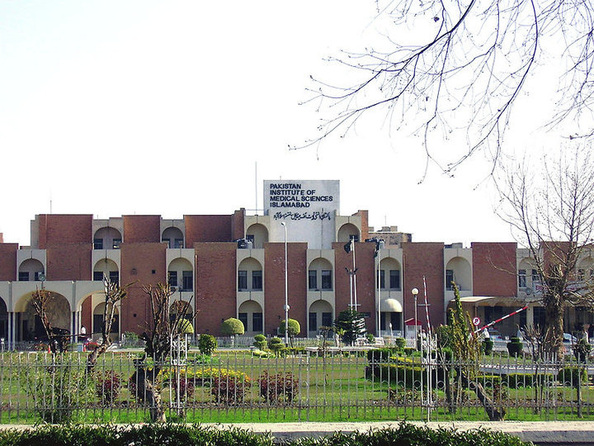
Pakistan Institute of Medical Sciences (PIMS)
Islamabad has a list of public and private medical centres. The largest hospital in Islamabad is Pakistan Institute of Medical Sciences hospital. It was established in 1985 as a teaching and doctor training institute. PIMS also functions as a National Reference Center and provides specialized diagnostic and curative services.
PIMS consists of five academic institutes; Quaid-i-Azam Postgraduate Medical College, College of Nursing, College of Medical Technology, School of Nursing, and Mother and Child Health Center.
According to Federal Bureau of Statistics, Government of Pakistan, in 2008 there were 12 hospitals, 76 dispensaries, and 5 Maternity and Child Welfare Centers in the city with total 5,158 beds.
(iii) Transport
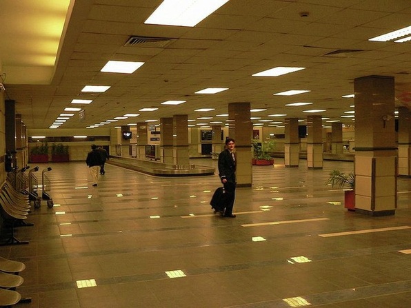
Benazir Bhutto International Airport
Islamabad is connected to major destinations around the world through Benazir Bhutto International Airport, previously known as Islamabad International Airport. The airport is the third largest in Pakistan and is located outside Islamabad, in Chaklala, Rawalpindi. In fiscal year 2004–2005, over 2.88 million passengers used Benazir Bhutto International Airport and 23,436 aircraft movements were registered.New Islamabad International Airport is under construction at Fateh Jang to cope with the increasing number of passengers. When completed in June 2013, the airport will be the largest in Pakistan. The airport will be built at a cost of $400 million and will be completed by mid 2013. This will be the first green field airport in Pakistan with an area of 3,600-acre (15 km2). All major cities and towns are accessible through regular trains and bus services running mostly from the neighbouring city of Rawalpindi. Lahore and Peshawar are linked to Islamabad through a network of motorways which has resulted in a significant reduction in travelling times between these cities. M-2 Motorway is 367 km long and connect Islamabad and Lahore. M-1 Motorway connects Islamabad with Peshawar and is 155 km long. Islamabad is linked to its 'Father' city Rawalpindi through the Faizabad Interchange, the first cloverleaf interchange in Pakistan with a daily traffic volume of about 48,000 vehicles.
Economy
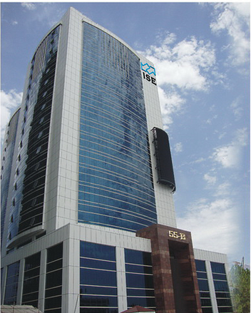
Islamabad Stock Exchange Building
Islamabad is a net contributor to the Pakistani economy, as whilst having only 0.8% of the country's population.Islamabad Stock Exchange, founded in 1989, is Pakistan's third largest stock exchange after Karachi Stock Exchange and Lahore Stock Exchange.The exchange has 118 members with 104 corporate bodies and 18 individual members. The average daily turnover of the stock exchange is over 1 million shares.
Islamabad has seen an expansion in information and communications technology with the addition two Software Technology Parks which house numerous national and foreign technological and IT companies. The tech parks are located in Evacuee Trust Complex and Awami Markaz. Awami Markaz houses 36 IT companies while Evacuee Trust house 29 companies.Call centers for foreign companies have been targeted as another significant area of growth, with the government making efforts to reduce taxes by as much as 10% in order to encourage foreign investments in the IT sector.
Most of Pakistan's state-owned companies like PIA, PTV, PTCL, OGDCL, and Zarai Taraqiati Bank Ltd. are based in Islamabad. The city is home to many branches of Karachi-based companies, banks, and TV channels. Headquarters of all major telecommunication operators such as PTCL, Mobilink, Telenor, Ufone, China Mobile and others are located in Islamabad.
Culture
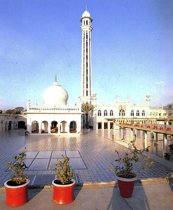
Mausoleum of Pir Meher Ali Shah
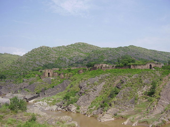
Islamabad is home to many migrants from other regions of Pakistan and has a cultural and religious diversity of considerable antiquity. Due to its location on the Pothohar Plateau, remnants of ancient cultures and civilizations such as Aryan, Soanian, and Indus Valley civilization can still be found in the region. A 15th century Gakhar fort, Pharwala Fort, is located near Islamabad which was built on the remains of a 10th century Hindu fort.Rawat Fort in the region was built by the Gakhars in 16th century where the grave of the Gakhar chief, Sultan Sarang Khan, is located.
Saidpur Village in Islamabad is named after Said Khan, the son of Sultan Sarang Khan. The 500 year old village was converted into the a place of Hindu worship by a Mughal commander, Raja Man Singh. He constructed a number of small ponds: Rama kunda, Sita kunda, Lakshaman kunda, and Hanuman kunda.The region is home to many Hindu temples that are preserved, showing the history of Hindu civilization and architecture in the region. However, religious minorities such as Hindus and Sikhs have faced a lack of religious facilities in Islamabad unakin to other metropolitan cities in the nation, such as Karachi or Lahore due to the the temples in the region being locked up and being controlled by the Evacuee Trust Property Board.
The shrine of Sufi mystic Pir Meher Ali Shah is located at Golra Sharif, which has a rich cultural heritage of the pre-Islamic period. Archaeological remains of the Buddhist era can still be found in the region.The shrine of Bari Imam was built by Mughal Emperor Aurangzeb. Thousands of devotees from across Pakistan attend the annual Urs of Bari Imam. The event is one of the largest religious gatherings in Islamabad. In 2004, the Urs was attended by more than 1.2 million people.
The Lok Virsa in Islamabad preserves the living folk and traditional culture of Pakistan. The Folk Heritage Museum, located near Shakarparian hills, has a large display of embroidered costumes, jewellery, woodwork, black printing, ivory, and bone work from the region and other parts of Pakistan.
