
What is meant by word "Continent"?
There is no universally accepted definition of the word "Continent"; the lay definition is "One of the main continuous bodies of land on the earth's surface" (Oxford English Dictionary).
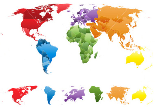
A continent is a large area of the land on Earth that is joined together. In general it is agreed there are seven continents: Africa, Antarctica, Asia, Europe, North America, Australia, and South America.
Most sources say that Australia is one of the seven continents. Others believe that Australia is part of another continent called Oceania. They believe that Oceania is a region which includes Australia, New Zealand and the Pacific Islands.
Some say that North America and South America are one continent. Some say that Europe and Asia are only parts of a continent called Eurasia. Some even say that Eurasia and Africa are one continent called Eurafrasia.
Boundaries between continents
The borders or boundaries separating the various continents of the topography of Earth are a matter of geographical convention. Several slightly different conventions are in use, just as the number of continents considered may range between five and seven, depending on whether the Americas and Eurasia are considered a single continent each.
According to the definition of a continent in the strict sense, an island cannot be part of any continent, but in practice most major islands are associated with a continent by convention.
There are three overland boundaries subject to definition:
The remaining boundaries concern the association of islands and archipelagos with specific continents, notably:
Often most of the Caribbean islands are considered part of North America, but Aruba, Bonaire, Curaçao, Trinidad and Tobago lie on the continental shelf of South America. On the other hand, the Venezuelan Isla Aves and the Colombian San Andrés and Providencia lie on the North American shelf.
The delineation of Asia from North America in the North PacificThe Bering Strait and Bering Sea separate the landmasses of Asia and North America, as well as forming the international boundary between Russia and the United States. This national and continental boundary separates the Diomede Islands in the Bering Strait, with Big Diomede in Russia and Little Diomede in the US. The Aleutian Islands are an island chain extending westward from the Alaska Peninsula toward Russia's Komandorski Islands and Kamchatka Peninsula. Most of them are always associated with North America, except for the westernmost Near Islands group, which is on Asia's continental shelf beyond the North Aleutians Basin and on rare occasions could be associated with Asia, which could then allow the US to be considered a transcontinental country.
According to the definition of a continent in the strict sense, an island cannot be part of any continent, but in practice most major islands are associated with a continent by convention.
There are three overland boundaries subject to definition:
- Between Asia and Africa:The usual line taken to divide Africa from Asia today is at the Isthmus of Suez along the path of the Suez Canal. This makes the Sinai Peninsula geographically Asian, and Egypt a transcontinental country.
- Between Asia and Europe (Dividing Eurasia): along the Bosporus, the Caucasus and the Urals (Historically also also north of the Caucasus, along the Kuma–Manych Depression or along the Don river)
- Between North America and South America (Dividing the Americas): the Isthmus of Panama
The remaining boundaries concern the association of islands and archipelagos with specific continents, notably:
- The delineation of Southeast Asia from Oceania.
- The delineation between Africa, Europe and Asia in the Mediterranean
- The delineation between Asia and Europe in the Arctic Ocean
- The delineation between Europe and North America in the Atlantic:Europe and North America are separated by the North Atlantic. In terms of associating islands with either continent, the boundary is usually drawn between Greenland and Iceland. The Norwegian islands of Jan Mayen and Svalbard in the Arctic Sea are usually associated with Europe.
Often most of the Caribbean islands are considered part of North America, but Aruba, Bonaire, Curaçao, Trinidad and Tobago lie on the continental shelf of South America. On the other hand, the Venezuelan Isla Aves and the Colombian San Andrés and Providencia lie on the North American shelf.
The delineation of Asia from North America in the North PacificThe Bering Strait and Bering Sea separate the landmasses of Asia and North America, as well as forming the international boundary between Russia and the United States. This national and continental boundary separates the Diomede Islands in the Bering Strait, with Big Diomede in Russia and Little Diomede in the US. The Aleutian Islands are an island chain extending westward from the Alaska Peninsula toward Russia's Komandorski Islands and Kamchatka Peninsula. Most of them are always associated with North America, except for the westernmost Near Islands group, which is on Asia's continental shelf beyond the North Aleutians Basin and on rare occasions could be associated with Asia, which could then allow the US to be considered a transcontinental country.
Continental models
If it is not working properly then click on image
The seven-continent model is usually taught in China and most English-speaking countries. The six-continent combined Eurasia model is preferred by the geographic community, the former states of the USSR (including Russia), and Japan. The six-continent combined America model is taught in Latin America, and some parts of Europe, including Greece, Italy, Belgium, Portugal and Spain. This model may be taught to include only the five inhabited continents (excluding Antarctica),as depicted in the Olympic logo.
The terms Oceania or Australasia are sometimes substituted for Australia to denote a continent encompassing the Australian mainland and various islands of the Pacific Ocean not part of other continents. For example, the Atlas of Canada names Oceania,as does the model taught in Italy and in Latin America and Iberia.
The terms Oceania or Australasia are sometimes substituted for Australia to denote a continent encompassing the Australian mainland and various islands of the Pacific Ocean not part of other continents. For example, the Atlas of Canada names Oceania,as does the model taught in Italy and in Latin America and Iberia.
United Nations geoscheme
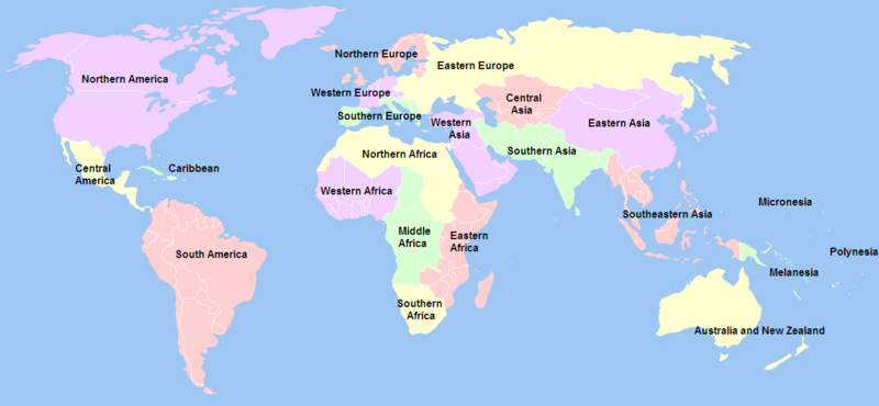
The United Nations geoscheme, created by the United Nations Statistics Division, divides the world into 'macro-geographical regions' and subregions.
The scheme was devised for statistical purposes and is used for carrying out statistical analysis. The macro-geographical regions are arranged to the extent possible according to continents. Within these groupings, smaller, geographical subregions and selected economic and other groupings allow for detailed analysis.
According to the UN, the assignment of countries or areas to specific groupings is for statistical convenience and does not imply any assumption regarding political or other affiliation of countries or territories.
Area and population
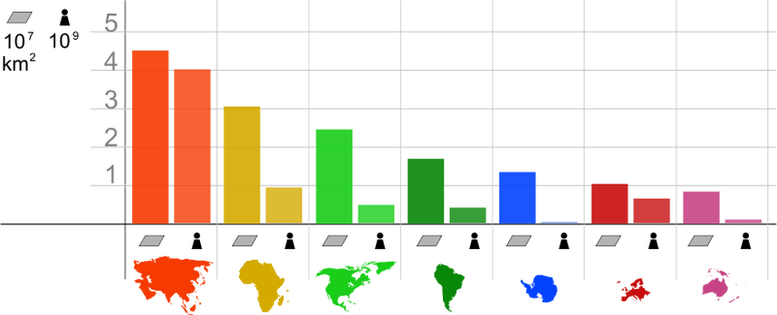
The following table summarises the area and population of each continent using the seven continent model, sorted by decreasing area.
|
|
Highest points Of each Continent
|
|
*Some sources claim Mount Wilhelm, 4,509 m (14,793 ft), as the highest mountain peak in Oceania, on account of Indonesia being part of Asia (Southeast Asia).
Lowest point Of each Continent
|
|
