
Largest Lakes By Continent
What is lake?
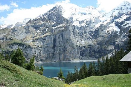
Oeschinen Lake in the Swiss Alps
A lake (From Latin lacus) is a large body of water larger and deeper than a pond within a body of land. Because a lake is not connected to any ocean, it is not a sea. Some lakes are very big and people in the past sometimes called them seas. Lakes do not flow, like rivers, but it is common that rivers flow into or out of them.
Most lakes on the surface of the Earth are fresh water and most are in the Northern Hemisphere. More than 60% of the lakes of the world are in Canada. Finland is known as The Land of the Thousand Lakes (There are 187,888 lakes in Finland, of which 60,000 are large).
Many lakes are man-made and are built to produce electricity, for recreation, to use the water in the industry, farming, or in houses.
If there are not rivers flowing out of the lake (see Endorheic basin), or they are few and small, the lake loses water only by evaporation or because the water flows through the soil pores. Where the water evaporates rapidly and the soil around the lake has a high salt level, as in very dry places, the water of the lake has a high concentration of salt and the lake is called a salt lake.
Largest lakes by continent
The largest lakes (surface area) by continent are:
- Australia \ Oceania - Lake Eyre (Salt lake) when filled; the largest permanent and freshwater lake in Oceania is Lake Taupo.
- Africa - Lake Victoria, also the third-largest freshwater lake on Earth. It is one of the Great Lakes of Africa.
- Antarctica - Lake Vostok (Subglacial)
- Asia - Lake Baikal (If the Caspian Sea is considered a lake, it is the largest in Eurasia, but is divided between the two geographic continents)
- North America - Lake Michigan-Huron, which is hydrologically a single lake. However, lakes Huron and Michigan are often considered separate lakes, in which case Lake Superior would be the largest.
- Europe - Lake Ladoga, followed by Lake Onega, both located in northwestern Russia.
- South America - Lake Titicaca, which is also the highest navigable body of water on Earth at 3,821 m above sea level. The much larger Lake Maracaibo is considered by some to be the second-oldest lake on Earth, but since it lies at sea level and nowadays is a contiguous body of water with the sea, others consider that it has turned into a bay.
Lake Eyre
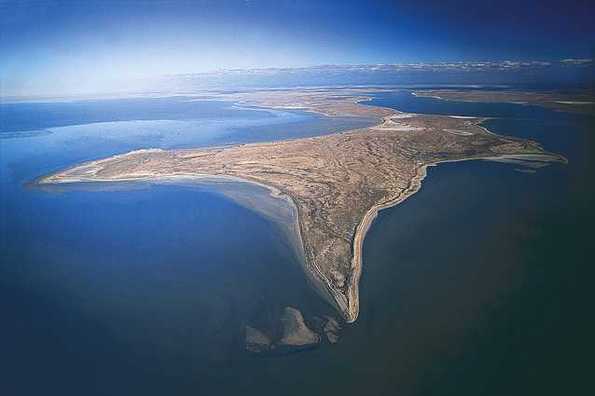
Lake Eyre is the lowest point in Australia, at approximately 15 m (49 ft) (AHD) below sea level, and, on the rare occasions that it fills, it is the largest lake in Australia. It is the focal point of the vast Lake Eyre Basin and is found some 700 km (435 mi) north of Adelaide.
The lake was named after Edward John Eyre who was the first European to sight it in 1840. It is located in the deserts of central Australia, in northern South Australia. The Eyre Basin is a large endorheic system surrounding the lakebed, the lowest part of which is filled with the characteristic salt pan caused by the seasonal expansion and subsequent evaporation of the trapped waters. Even in the dry season there is usually some water remaining in Lake Eyre, normally collecting in a number of smaller sub-lakes on the playa.
Typically a 1.5 m (5 ft) flood occurs every three years, a 4 m (13 ft) flood every decade, and a fill or near fill four times a century. The water in the lake soon evaporates with a minor and medium flood drying by the end of the following summer.
Lake Victoria

Lake Victoria or Victoria Nyanza (Also known as Ukerewe, The Eye of the Rhino, Nalubaale, Sango, or Lolwe) is one of the African Great Lakes. The lake was named after the United Kingdom's Queen Victoria, by John Hanning Speke, the first European to see the lake.
With a surface area of 68,800 square kilometres (26,600 sq mi), Lake Victoria is Africa’s largest lake, and the largest tropical lake in the world, and is Earth's second largest freshwater lake - only North America's Lake Superior is larger. In terms of volume, it is the world’s eighth largest continental lake, containing 2,750 cubic kilometres (2.2 billion acre-feet) of water.
The lake receives most of its water from direct precipitation. Its largest influent is the Kagera River, the mouth of which lies on the lake's western shore. The only river to leave the lake, the White Nile (known as the "Victoria Nile" as it leaves the lake), leaves at Jinja, Uganda, on the lake’s north shore .
Lake Victoria occupies a shallow depression in the East African Plateau, and has a maximum depth of 84 metres (276 ft) and an average depth of 20 metres (66 ft). Its catchment area covers 184,000 square kilometres (71,040 sq mi). The lake has a shoreline of some 4,828 kilometres (3,000 mi), with islands constituting some 3.7% of this length, and is divided between three countries: Kenya (6% or 4,100 km2/1,600 sq mi), Uganda (45% or 31,000 km2/12,000 sq mi) and Tanzania (49% or 33,700 km2/13,000 sq mi).Lake Victoria supports Africa's largest inland fishery.
Lake Vostok
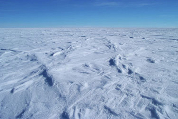
Lake Vostok (Russian: восток, "East") is the largest of more than 140 subglacial lakes found under the surface of Antarctica. It is located beneath Russia's Vostok Station, 4,000 meters (13,000 ft) under the surface of the central Antarctic ice sheet. It is 250 km long by 50 km wide at its widest point, thus similar in size to Lake Ontario, and is divided into two deep basins by a ridge. The water over the ridge is about 200 m (650 ft) deep, compared to roughly 400 m (1,300 ft) deep in the northern basin and 800 m (2,600 ft) deep in the southern. Lake Vostok covers an area of 15,690 km² (6,058 mi²). It has an estimated volume of 5,400 km³ (1,300 cubic miles) and consists of fresh water. The average depth is 344 m. In May 2005 an island was found in the center of the lake.
Airborne ice-penetrating radar data first showed lakes beneath the Antarctic ice-sheet in the late 1960s and early 1970s. The existence of Lake Vostok was first noted in 1973 by scientists of the Scott Polar Research Institute, but not named by them.
Russian and British scientists delineated the lake in 1996 by integrating a variety of data, including airborne ice-penetrating radar imaging observations and spaceborne radar altimetry. It has been confirmed that the lake contains large amounts of liquid water under the more than three-kilometer thick icecap, promising to be the most unspoiled lake on Earth.
The lake water is undoubtedly very old. Initially, it was thought that the same water had made up the lake since the time of its formation, giving a residence time in the order of one million years. Later research by Robin Bell and Michael Studinger from the Lamont-Doherty Earth Observatory of Columbia University suggested that the water of the lake is continually freezing and being carried away by the motion of the Antarctic ice sheet, while being replaced by water melting from other parts of the ice sheet in these high pressure conditions. This resulted in an estimate that the entire volume of the lake is frozen and removed every 13,300 years its effective mean residence time. In comparison, the similarly sized Lake Ontario has a residence time of six years, which is typical for a lake of that size.
The average water temperature is around −3 °C (27 °F); it remains liquid below the normal freezing point because of high pressure from the weight of the ice above it. Geothermal heat from the Earth's interior warms the bottom of the lake. The ice sheet itself insulates the lake from cold temperatures on the surface.
Lake Baikal
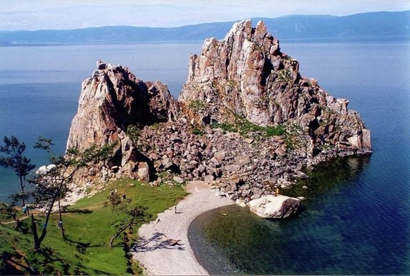
Lake Baikal meaning "Nature lake"is the world's second most voluminous lake, after the Caspian Sea if it consider as lake. It is the most voluminous freshwater lake in the world with an average depth of 744.4 m (2,442 ft) and contains a total of roughly 20% of the world's surface fresh water.Located in the south of the Russian region of Siberia between Irkutsk Oblast to the northwest and the Buryat Republic to the southeast, near the city of Irkutsk, the body of water is also known as the "Pearl of Siberia".
At 1,642 metres (5,387 ft) (Baikal central part 53°14′59″N 108°05′11″E), Lake Baikal is the deepest, and among the clearest of all lakes in the world. At more than 25 million years old, Baikal is also the world's oldest lake. Like Lake Tanganyika, Lake Baikal was formed as an ancient rift valley, having the typical long crescent shape with a surface area of 31,722 km2/12,248 sq mi, less than that of Lake Superior or Lake Victoria. Baikal is home to more than 1,700 species of plants and animals, two thirds of which can be found nowhere else in the world and was declared a UNESCO World Heritage Site in 1996.It is also home to Buryat tribes who reside on the eastern side of Lake Baikal,rearing goats, camels, cattle and sheep,where the regional temperature varies from a minimum of −19 °C (−2.2 °F) in winter to maximum of 14 °C (57 °F) in summer.
At 1,642 metres (5,387 ft) (Baikal central part 53°14′59″N 108°05′11″E), Lake Baikal is the deepest, and among the clearest of all lakes in the world. At more than 25 million years old, Baikal is also the world's oldest lake. Like Lake Tanganyika, Lake Baikal was formed as an ancient rift valley, having the typical long crescent shape with a surface area of 31,722 km2/12,248 sq mi, less than that of Lake Superior or Lake Victoria. Baikal is home to more than 1,700 species of plants and animals, two thirds of which can be found nowhere else in the world and was declared a UNESCO World Heritage Site in 1996.It is also home to Buryat tribes who reside on the eastern side of Lake Baikal,rearing goats, camels, cattle and sheep,where the regional temperature varies from a minimum of −19 °C (−2.2 °F) in winter to maximum of 14 °C (57 °F) in summer.
Lake Michigan-Huron
Lake Michigan-Huron is geologically the largest of the North American Great Lakes. Traditionally considered to be two separate lakes, Lake Michigan and Lake Huron, it is hydrologically a single body of water connected by the Straits of Mackinac.
The straits are 5 miles (8.0 km) wide and 120 feet (37 m) deep, small in comparison to the body of water as a whole. The two sections have thus long been considered distinct lakes. However, they lie at the same surface elevation, 577 feet (176 m), rise and fall together, and the flow of water between them at times reverses from eastward to westward. The National Oceanic and Atmospheric Administration states, "Lakes Michigan and Huron are considered to be one lake hydraulically because of their connection through the deep Straits of Mackinac."The United States Army Corps of Engineers says "Lakes Michigan and Huron are considered to be one lake, as they rise and fall together due to their union at the Straits of Mackinac."
At 45,410-square-mile (117,600 km2), Lake Michigan-Huron is the largest of the Great Lakes in terms of surface area, being 48% of the total, and indeed the largest lake in the world. (It is exceeded in surface area only by the Black and Caspian Seas, which by tradition, by geology, and due to their salinity are commonly counted as seas rather than as lakes). Lake Superior holds more water, 3,000 cubic miles (12,500 km3) compared to Michigan-Huron's 2,000 cubic miles (8,300 km3), which makes Michigan-Huron the fourth largest lake by volume in the world after lakes Baikal, Tanganyika, and Superior.
During the last ice age, what is now Huron-Michigan was indeed two lakes, with what is now Lake Huron (known to geologists as Lake Stanley) separate from what is now Lake Michigan (Lake Chippewa). Before that Lake Chicago occupied the southern tip of the Lake Michigan basin, at the southern extent of the glaciers.
Lake Titicaca
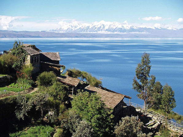
Lake Titicaca is a lake located on the border of Peru and Bolivia. It sits 3,812 m (12,500 ft) above sea level, making it one of the highest commercially navigable lakes in the world. By volume of water, it is also the largest lake in South America.
The origin of the name Titicaca is unknown. It has been translated as "Rock Puma", allegedly for its resembling the shape of a puma hunting a rabbit, combining words from the local languages Quechua and Aymara, and as well as translated as "Crag of Lead." Locally, the lake goes by several names. Because the southeast quarter of the lake is separate from the main body (connected only by the Strait of Tiquina), the Bolivians call it Lago Huiñaymarca (Quechua: Wiñay Marka) and the larger part Lago Chucuito. In Peru, these smaller and larger parts are referred to as Lago Pequeño and Lago Grande, respectively.
The lake is located at the northern end of the endorheic Altiplano basin high in the Andes on the border of Peru and Bolivia. The western part of the lake lies within the Puno Region of Peru, and the eastern side is located in the Bolivian La Paz Department.
The lake is composed of two nearly separate sub-basins that are connected by the Strait of Tiquina which is 800 m (2,620 ft) across at the narrowest point. The larger sub-basin, Lago Grande (also called Lago Chucuito) has a mean depth of 135 m (443 ft) and a maximum depth of 284 m (932 ft). The smaller sub-basin, Wiñaymarka (also called Lago Pequeño, "little lake") has a mean depth of 9 m (30 ft) and a maximum depth of 40 m (131 ft).The overall average depth of the lake is 107 m (351 ft).
Lake Titicaca is fed by rainfall and meltwater from glaciers on the sierras that abut the Altiplano. Five major river systems feed into Lake Titicaca. In order of their relative flow volumes these are Ramis, Coata, Ilave, Huancané, and Suchez. More than 20 other smaller streams empty into Titicaca, and the lake has 41 islands, some of which are densely populated.
The cold sources and winds over the lake give it an average surface temperature of 10 to 14 °C (50 to 57 °F). In the winter (June-September), mixing occurs with the deeper waters, which are always between 10 to 11 °C (50 to 52 °F).
Some Other Notable Lakes
- The longest lake is Lake Tanganyika, with a length of about 660 km (measured along the lake's center line).
- The world's highest lake is the crater lake of Ojos del Salado, at 6,390 metres (20,965 ft).
- The highest large freshwater lake in the world is Lake Manasarovar in Tibet Autonomous Region of China
- The largest lake located on an island is Nettilling Lake on Baffin Island, with an area of 5542 km² and a maximum length of 123 km.
- Lake Toba on the island of Sumatra is located in what is probably the largest resurgent caldera on Earth.
- The largest lake located completely within the boundaries of a single city is Lake Wanapitei in the city of Sudbury, Ontario, Canada. Before the current city boundaries came into effect in 2001, this status was held by Lake Ramsey, also in Sudbury.
- Lake Enriquillo in Dominican Republic is the only saltwater lake in the world inhabited by crocodiles.
