
Eight Lowest Points on Earth
Name of Point |
Country |
Elevation Below Sea Level |
Dead Sea |
Jordan, Israel, West Bank |
−424 m (−1,391 ft) |
Lake Assal |
Djibouti |
−155 m (−509 ft) |
Aydingkol Lake |
China |
−154 m (−505 ft) |
Qattara Depression |
Egypt |
−133 m (−436 ft) |
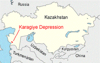
Karagiye Depression |
Kazakhstan |
−132 m (−433 ft) |
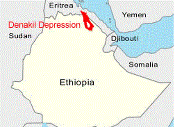
Denakil Depression |
Ethiopia |
N/A |
Laguna del Carbón |
Argentina |
−105 m (−344 ft) |
Badwater Basin |
USA |
−86 m (−282 ft) |
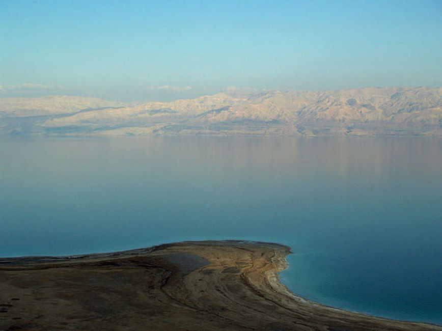
A view from the Israeli side looking across to Jordan
Dead Sea- In Dead Sea Depression
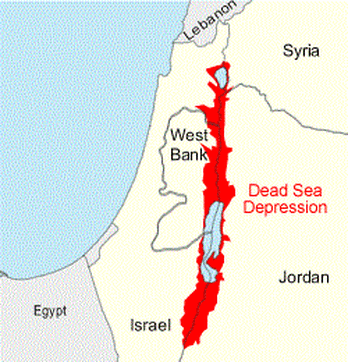
The Dead Sea Depression is an extensive area of land that is below sea level. It contains the Dead Sea, the Sea of Galilee, a portion of the Jordan River, large areas of cultivated land and many communities. The shoreline of the Dead Sea is the lowest land on Earth.
The Dead Sea (Arabic: البحر الميت Al-Bahr al-Mayyit or less commonly bahr lut,بحر لوط, "the Sea of Lot", Hebrew: Yam Ha-Melah, "Sea of Salt",Urdu بحیرہ مردار), also called the Salt Sea, is a salt lake bordering Jordan to the east and Israel and the West Bank to the west.
Its surface and shores are 422 metres (1,385 ft) below sea level,the lowest elevation on the Earth's surface on dry land. The Dead Sea is 378 m (1,240 ft) deep, the deepest hypersaline lake in the world. It is 8.6 or 9 times more salty than the ocean.This salinity makes for a harsh environment where animals cannot flourish, hence its name. The Dead Sea is 67 kilometres (42 mi) long and 18 kilometres (11 mi) wide at its widest point. It lies in the Jordan Rift Valley, and its main tributary is the Jordan River.
The Dead Sea has attracted visitors from around the Mediterranean basin for thousands of years. It was one of the world's first health resorts (for Herod the Great), and it has been the supplier of a wide variety of products, from balms for Egyptian mummification to potash (Potassium,K) for fertilizers. People also use the salt and the minerals from the Dead Sea to create cosmetics and herbal sachets. In 2009, 1.2 million foreign tourists visited on the Israeli side.
The sea has a density of 1.24 kg/L, making swimming difficult but providing a relaxing floating experience for tourists.
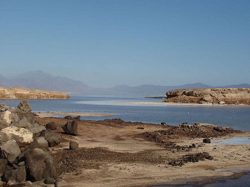
Lake Assal
Lake Assal-In the Afar Depression
The shoreline of Lake Assal is the lowest point in Africa and the second lowest location on Earth.Lake Assal is located in the Afar Depression which is formed at a triple junction of tectonic plates (Indian, African and Arabian). It Latitude and Longitude is 11°39′N 42°25′E.
Lake Assal (French: Lac Assal) is a crater lake (A crater lake is a lake that forms in a volcanic crater or caldera, such as a maar, or in an impact crater caused by a meteorite) in central Djibouti, located at the southern border of Tadjoura Region, touching Dikhil Region, some 120 km (75 mi) west of Djibouti city (Capital of the Republic of Djibouti). It lies 155 m (509 ft) below sea level in the Afar Depression and its shores comprise the lowest point on land in Africa and the second lowest land depression on Earth after the Dead Sea. It measures 19 by 7 km (4.3 mi) and has an area of 54 km2 (21 sq mi). The maximum depth is 40 m (130 ft), whereas the mean depth is 7.4 m (24 ft), which makes for a water volume of 400 million cubic metres (320,000 acre·ft). The catchment area measures 900 km2 (350 sq mi), and there is just a residual runoff of fresh water into the lake.
Lake Assal is considered the most saline body of water on earth outside Antarctica, with 34.8 percent salt concentration (up to 40% at 20 m (66 ft) depth), similar to Garabogazköl and higher than the 33.7 percent level in the Dead Sea (often incorrectly considered the world's most saline lake), and an average of 3.5 percent in the world's oceans. Only some hypersaline lakes of the McMurdo Dry Valleys in Antarctica such as Don Juan Pond have a higher salinity.
One thing that makes Assal unique is that, unlike the other major hypersaline lakes of the world, its major source of water is not from incoming streams. The sources of the lake are hot springs whose salinity is close to sea water, which are fed by the Gulf of Tadjoura (French: Golfe de Tadjoura), the western extension of the Gulf of Aden, specifically the nearly closed-off bay Ghoubet Kharab, about 10 km southeast of the lake.
The area is wild and desert-like, and no fauna or flora can be seen in the syrupy waters of the lake. The high temperature of the water (33-34 °C) favors evaporation, and it is surrounded by a salt pan (extending west and mainly northwest). The salt is mined and transported by caravan to Ethiopia.
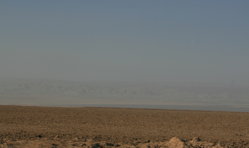
Aydingkol Lake
Aydingkol Lake-In Turpan Depression
The Turfan Basin is a below sea level area in the Xinjiang Autonomous Region of western China. The lowest part of the basin is occupied by Aydingkol Lake. The shoreline of Aydingkol Lake is the third lowest location on Earth.It Latitude and Longitude is 42°40′N 89°14′E.
Aydingkol is a lake in the Turpan Depression, Xinjiang Uyghur Autonomous Region,People's Republic of China. At 154 M below sea level, it is the third lowest land point on Earth (after the Dead Sea and Lake Assal).This lake is now totally dried, and very muddy and salty.In ancient times, Ayding Lake was known as juéluòwǎn (觉洛浣). The Uyghur derived name Aydingköl means "moon lake", due to the lake having a layer of white salt along its edge, giving the appearance of a shining moon.
The lake is located in the south hinterland of the Turpan Depression, approximately 35 kilometres away from the city of Turpan. From east to west, the lake spans 40 kilometres; the north-south span is 8 kilometres; and the total area of the lake is 200 square kilometres. The lake was formed from the formation of an orogeny of the Himalayas 249 million years ago, and once held approximately 5 million square kilometres of inland sea, which at one time surged up and became vastly extended. During the winter of 1948, the lake basin was once filled with freshwater, which primarily originated from melted snow water from the mountains, as well as supplementary groundwater; owing to the lesser use of water to irrigate cultivated land during the winter, the water level was higher. During the summertime, the water level declined as a result of increased use of irrigation water for farming, as well as significant natural evaporation. Due to the expansion of farming in the region, the population using water from the lake subsequently increased, and coupled with the effects of global warming, by 1958 the lake only held up to 22 square kilometres, with a water depth of about 0.8 metres. In 2000, except for the southwest region, little lakewater remains, and the entire lake area has become a saltpan, with the centre of the lake holding silt swamps, and no longer holds any native birds. During times of intense sunshine, mirages can often be seen.
Nowadays, Ayding Lake has a salt mill, which uses the region's alum salt crystals and saltpeter raw materials to manufacture chemical products. Scenic tours also run near the lake.
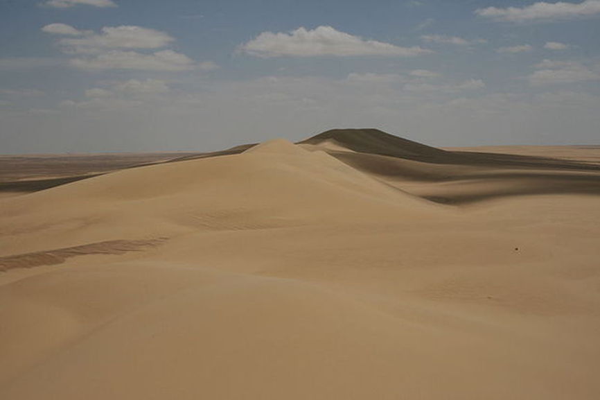
A majestic view of sand dunes in the Qattara Depression which is almost impassible to motorized vehicles
Qattara Depression
The Qattara Depression (Arabic: منخفض القطارة Munḫafaḍ al-Qaṭṭārah) is a desert basin within the Libyan Desert of northwestern Egypt in the Matruh Governorate. The Depression, at 133 m below sea level, contains the second lowest point in Africa (The lowest being Lake Assal in Djibouti). The Depression covers about 19,500 km² (7,000 square miles), a size comparable to Lake Erie, and at its maximum is 220 km in length and 120 km in width. The bottom of the depression consists of a salt pan.It Latitude and Longitude is 29°32′N 27°07′E.
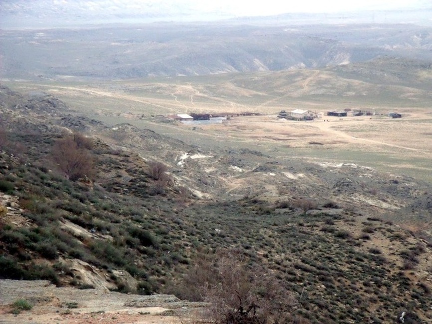
Karagiye Depression
Karagiye Depression
The Karagiye Depression is located in southwestern Kazakhstan. It has an elevation of approximately 132 meters below sea level.It Latitude and Longitude is 43°27′N 51°45′E.
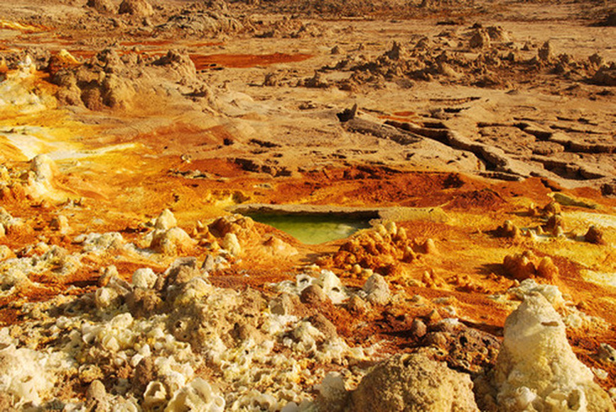
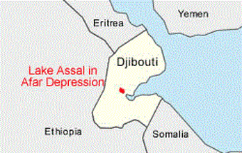
Denakil Desert
Denakil Depression In the Afar Depression
The Denakil Depression is a low area within the Afar Depression of Ethiopia. The Afar Depression is formed at a triple junction of tectonic plates (Indian, African and Arabian). The relative motions of the plates produce a divergence that results in the Denakil Depression.It Latitude and Longitude is 13°16′N 40°54′E.
The Afar Depression (also called the Danakil Depression or the Afar Triangle) is a geological depression, includes Afar Triple Junction, near the Horn of Africa, also a part of the Great Rift Valley, where it overlaps Eritrea, the Afar Region of Ethiopia, and Djibouti. Afar is well known as one of the cradles of hominids, containing the Middle Awash, site of many fossil hominid discoveries such as Ardi, (ardipithecus ramidus); Gona (Gawis cranium), site of the world's oldest stone tools; and Hadar, site of Lucy, the fossilized specimen of Australopithecus afarensis.The Afar Depression includes the Danakil Desert and the lowest point in Africa, Lake Asal (155 metres / 509 feet below sea level). Only the Awash River flows into the depression, where it ends in a chain of lakes that increase in salinity. Dallol is also part of the Depression, one of the hottest places year-round anywhere on Earth, with a shaded air-temperature record of 64.4 °C (148 °F). The climate varies from around 25 °C (77 °F) during the rainy season (September–March) to 48 °C (118 °F) during the dry season (March–September).
The Afar Depression (also called the Danakil Depression or the Afar Triangle) is a geological depression, includes Afar Triple Junction, near the Horn of Africa, also a part of the Great Rift Valley, where it overlaps Eritrea, the Afar Region of Ethiopia, and Djibouti. Afar is well known as one of the cradles of hominids, containing the Middle Awash, site of many fossil hominid discoveries such as Ardi, (ardipithecus ramidus); Gona (Gawis cranium), site of the world's oldest stone tools; and Hadar, site of Lucy, the fossilized specimen of Australopithecus afarensis.The Afar Depression includes the Danakil Desert and the lowest point in Africa, Lake Asal (155 metres / 509 feet below sea level). Only the Awash River flows into the depression, where it ends in a chain of lakes that increase in salinity. Dallol is also part of the Depression, one of the hottest places year-round anywhere on Earth, with a shaded air-temperature record of 64.4 °C (148 °F). The climate varies from around 25 °C (77 °F) during the rainy season (September–March) to 48 °C (118 °F) during the dry season (March–September).
Laguna del Carbón
Laguna del Carbón In San Julían's Great Depression
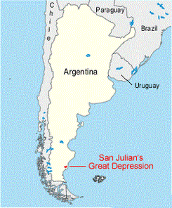
San Julian's Great Depression is located in southeastern Argentina. It is the lowest land location in both the Western Hemispheres. The deepest part is Laguna del Carbón (Spanish: Coal Lagoon) is an endorheic salt lake in the Gran Bajo de San Julián of Santa Cruz Province, Argentina, 54 km from Puerto San Julián. at approximately 105 meters below sea level. The area has abundant salt marshes.It Latitude and Longitude is 49°35′S 68°20′W.
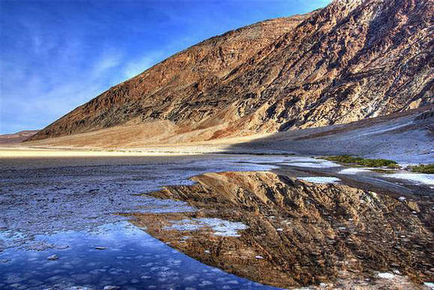
In Death Valley National Park.
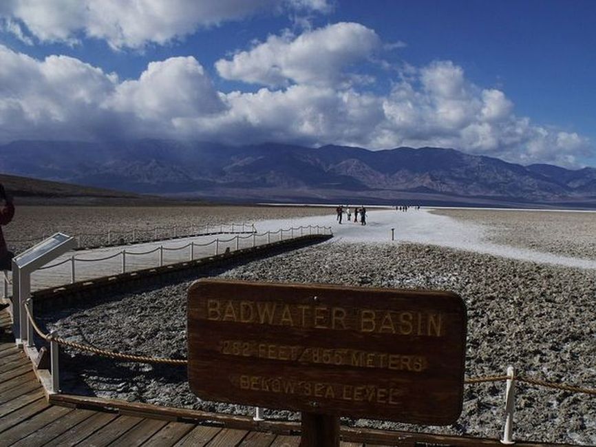
Badwater Basin In Death Valley
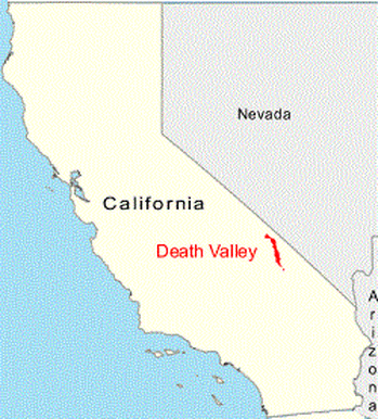
Death Valley is a desert located in Eastern California. Situated within the Mojave Desert, it features the lowest, driest, and hottest locations in North America.Badwater, a basin located in Death Valley, is the specific location (36° 15' N 116° 49.5' W) of the lowest elevation in North America at 282 feet (86.0 m) below sea level.Death Valley holds the record for the highest reliably reported temperature in the Western hemisphere, 134 °F (56.7 °C) at Furnace Creek on July 10, 1913 just short of the world record, 136 °F (57.8 °C) in Al 'Aziziyah, Libya, on September 13, 1922.
Located near the border of California and Nevada, in the Great Basin, east of the Sierra Nevada mountains, Death Valley constitutes much of Death Valley National Park and is the principal feature of the Mojave and Colorado Deserts Biosphere Reserve. It is located mostly in Inyo County, California. It runs from north to south between the Amargosa Range on the east and the Panamint Range on the west; the Sylvania Mountains and the Owlshead Mountains form its northern and southern boundaries, respectively. It has an area of about 3,000 sq mi (7,800 km2).
Badwater Basin is an endorheic basin in Death Valley National Park, Death Valley, Inyo County, California, noted as the lowest point in North America, with an elevation of 282 ft (86 m) below sea level.
The site itself consists of a small spring-fed pool of "bad water" next to the road in a sink; the accumulated salts of the surrounding basin make it undrinkable, thus giving it the name. The pool does have animal and plant life, including pickleweed, aquatic insects, and the Badwater snail.
Adjacent to the pool, where water is not always present at the surface, repeated freeze–thaw and evaporation cycles gradually push the thin salt crust into hexagonal honeycomb shapes.
The pool itself is not actually the lowest point of the basin: the lowest point (which is only slightly lower) is several miles to the west and varies in position. However, the salt flats are hazardous to traverse (in many cases being only a thin white crust over mud), and so the sign is at the pool. The area is often mistakenly described as the lowest elevation in the Western Hemisphere, however, the record goes to Laguna del Carbón in Argentina at -105 m (−344 ft).
At Badwater, significant rainstorms flood the valley bottom periodically, covering the salt pan with a thin sheet of standing water. Each newly-formed lake does not last long though, because the 1.9 in (48 mm) of average rainfall is overwhelmed by a 150 in (3,800 mm) annual evaporation rate. This, the United States' greatest evaporation potential, means that even a 12-foot-deep, 30-mile-long lake would dry up in a single year. While the basin is flooded, some of the salt is dissolved; it is redeposited as clean crystals when the water evaporates.A popular site for tourists is the sign marking "sea level" on the cliff above Badwater.
