
Karakoram Highway
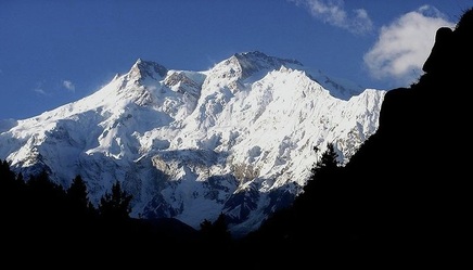
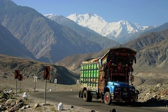 Truck passing through the Astore District of Pakistan, with Nanga Parbat in the background |
Quick Facts
|
The Karakoram Highway (KKH) (Urdu: شاہراہ قراقرم, Chinese: 中巴公路) is the highest paved international road in the world. It connects China and Pakistan across the Karakoram mountain range, through the Khunjerab Pass, at an altitude of 4,693 m/15,397 ft as confirmed by both SRTM and multiple GPS readings. It connects China's Xinjiang region with Pakistan's Gilgit-Baltistan and also serves as a popular tourist attraction. It is now part of the route officially known as as N-35 within Pakistan. Due to its high elevation and the difficult conditions in which it was constructed, it is also referred to as the "Ninth Wonder of the World."
History of Road
The Karakoram Highway, also known as the Friendship Highway in China, was built by the governments of Pakistan and China, it was started in 1959 and was completed in 1979 open to the public since 1986 about 810 Pakistanis and about 200 Chinese workers lost their lives, mostly in landslides and falls, while building the highway. The route of the KKH traces one of the many paths of the ancient Silk Road.
On the Pakistani side, the road was constructed by FWO (Frontier Works Organization), employing the Pakistan Army Corps of Engineers. Presently, the Engineer-in-Chief' Branch of the Pakistani Army is working on a project documenting the history of the highway. A book 'History of Karakoram Highway' has been written by Brigadier Muhammad Mumtaz Khalid. It is in two volumes. In the first volume the author discusses the land and the people, the pre-historic communication system in the Northern Areas, the need for having an all weather road link with Gilgit and the construction of Indus Valley Road. The second volume records events leading to conversion of Indus Valley Road to Karakoram Highway, the difficulties in its construction and the role of Pakistan Army Corps of Engineers and the Chinese in its construction.
On the Pakistani side, the road was constructed by FWO (Frontier Works Organization), employing the Pakistan Army Corps of Engineers. Presently, the Engineer-in-Chief' Branch of the Pakistani Army is working on a project documenting the history of the highway. A book 'History of Karakoram Highway' has been written by Brigadier Muhammad Mumtaz Khalid. It is in two volumes. In the first volume the author discusses the land and the people, the pre-historic communication system in the Northern Areas, the need for having an all weather road link with Gilgit and the construction of Indus Valley Road. The second volume records events leading to conversion of Indus Valley Road to Karakoram Highway, the difficulties in its construction and the role of Pakistan Army Corps of Engineers and the Chinese in its construction.
The Highway
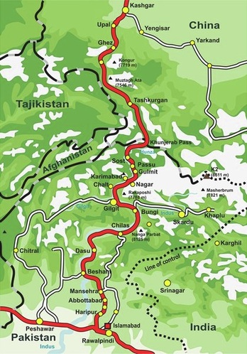
The highway, connecting Gilgit-Baltistan of Pakistan to the ancient Silk Road, runs approximately 1,300 km from Kashgar, a city in the Xinjiang region of China, to Abbottabad, of Pakistan. An extension of the highway south west from Abbottabad, in the form of N-35, meets the Grand Trunk Road, N-5 at Hassanabdal, Pakistan.
The highway cuts through the collision zone between the Eurasian and Indian plates, where China, Tajikistan, Afghanistan and Pakistan come within 250 km of each other. Owing largely to the extremely sensitive state of the Kashmir conflict between India and Pakistan, the Karakoram highway has strategic and military importance.
On June 30, 2006, a memorandum of understanding was signed between the Pakistani Highway Administration and China's State-owned Assets Supervision and Administration Commission (SASAC) to rebuild and upgrade the Karakoram Highway. According to SASAC, the width of the highway will be expanded from 10 metres to 30 metres, and its transport capacity will be increased three times. As well, the upgraded road will be constructed to particularly accommodate heavy-laden vehicles and extreme weather conditions.
China and Pakistan are also planning to link the Karakoram Highway to the southern port of Gwadar in Balochistan through the Chinese-aided Gwadar-Dalbandin railway, which extends up to Rawalpindi.
(i).Pakistani section
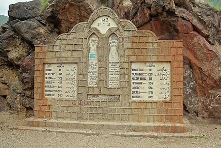
Milestone near Besham in Pakistan.
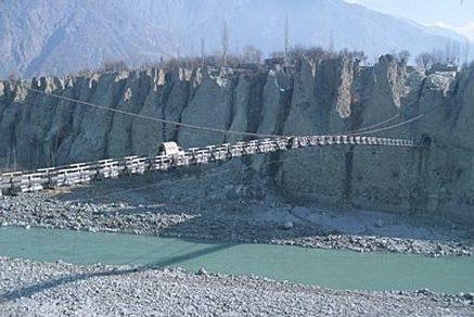
The Pakistani section of the highway is 806 km long. It starts from Abbottabad (though N-35 of which KKH is now a part, officially starts from Hassanabdal). The highway meets the Indus River at Thakot, and continues along the river until Bunji, where the Gilgit River joins the Indus River. This is the place where three great mountain ranges meet, the Hindukush, the Himalaya and the Karakoram. The western end of the Himalayas, marked by the 9th highest peak in the world, Nanga Parbat can be seen from the highway. The highway passes through the capital of the Gilgit-Baltistan, Gilgit, and continues to the beautiful valleys of Nagar and Hunza, along the Hunza River. Many of the highest mountains, lakes and glaciers in the Karakoram can be directly seen from the highway in this section. Finally, the highway meets the Pakistan-China border at Khunjerab Pass.
(ii).Chinese Section
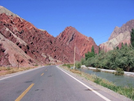
The Karakoram Highway in the Xinjiang region of China.
The Chinese Section of the Karakoram Highway follows the north-south Sarykol ('Yellow Lake') valley just west of the Tarim Basin, which is barely visible in the satellite image at left. The road from Kashgar goes southwest about 80 km and then turns west to enter the Gez (Ghez) River canyon between Chakragil mountain on the north and Kongur mountain on the south. From the Gez canyon the population becomes Kirgiz. Having climbed up to the valley, the road turns south past Kongur, Karakul Lake and Muztagh Ata on the east. Below Muztagh Ata a new road goes west over the Kulma Pass to join the Pamir Highway in Gorno-Badakhshan, Tajikistan. The main road continues over a low pass (where the population becomes Tajik) and descends to Tashkurgan. Further south a valley and jeep track leads west towards the Wakhjir Pass to the Wakhan Corridor. Next the road turns west to a checkpost and small settlement at Pirali, and then the Khunjerab Pass, beyond which is Pakistan, the Khunjerab River and Hunza.
(In 747 Gao Xianzhi, a Tang general crossed the Broghol Pass into what is now Pakistan - the furthest Chinese penetration in this direction. He was later defeated at the Battle of Talas, and the Chinese withdrew from the region.)
(In 747 Gao Xianzhi, a Tang general crossed the Broghol Pass into what is now Pakistan - the furthest Chinese penetration in this direction. He was later defeated at the Battle of Talas, and the Chinese withdrew from the region.)
Major Towns, Mountains and glaciers, Rivers and lakes, Rock art and petroglyphs
Major Towns
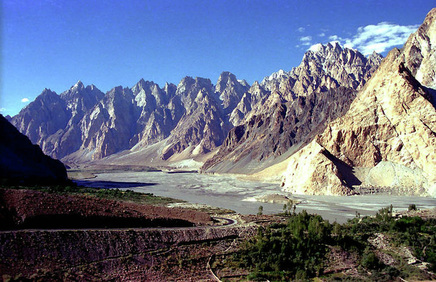
KKH near Passu in Pakistan
In Pakistan
- Besham
- Chilas
- Gilgit
- Danyor
- Chalt
- Nagar, Pakistan
- Hunza
- Gulmit
- Passu
- Sost
- Tashkurgan Town
- Ghez
- UpalKashgar
Mountains and glaciers
Karakoram Highway provides the pathway to expeditions for almost all peaks in Gilgit-Baltistan of Pakistan, Kashmir and several peaks in Xinjiang China. The region includes some of the world's largest glaciers like the Baltoro Glacier. Five of the Eight-thousanders (mountains taller than 8,000m) of the world that are in Pakistan are accessible by the highway. The notable mountains that can be directly seen while traveling on the highway are:
- Nanga Parbat, Gilgit-Baltistan, Pakistan, 9th highest of the world at 8,126m
- Rakaposhi, Gilgit-Baltistan, Pakistan, 27th highest of the world at 7,788m
- Diran, Gilgit-Baltistan, Pakistan, most dangerous mountain in Pakistan
- Shishpar, Gilgit-Baltistan, Pakistan
- Ultar Peak, Gilgit-Baltistan, Pakistan
- Tupopdan, Gilgit-Baltistan, Pakistan, also known as Cathedral Peaks near Passu
- Minapin Glacier
- Passu Glacier
- Ghulkin Glacier
- Khunjerab Glacier
Rivers and lakes
Several rivers and lakes are also made accessible by the highway. These include:
- Indus River
- Hunza River
- Gilgit River
- Ghujerab River
- Karakul Lake in Xinjiang (China)
Rock art and petroglyphs
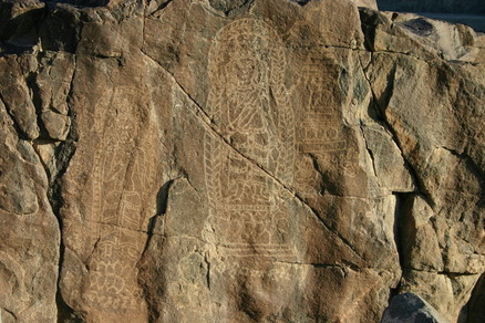
Ancient petroglyphs near Chilas
There are more than 20,000 pieces of rock art and petroglyphs all along the highway that are concentrated at ten major sites between Hunza and Shatial. The carvings were left by various invaders, traders and pilgrims who passed along the trade route, as well as by locals. The earliest date back to between 5000 BC and 1000 BC, showing single animals, triangular men and hunting scenes in which the animals are larger than the hunters. These carvings were pecked into the rock with stone tools and are covered with a thick patina that yields their age.
Weather
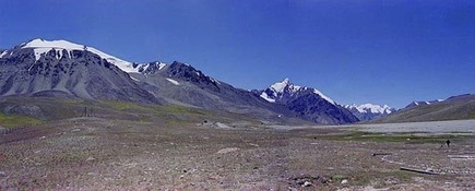
Khunjerab Pass Pakistan China
The KKH is best traveled in the spring or early autumn. Heavy snow during harsh winters can shut the highway down for extended periods. Heavy monsoon rains, around July and August, cause occasional landslides that can block the road for hours or more. The border crossing between China and Pakistan at Khunjerab Pass is open only between May 1 and December 31 of every year.
Tourism
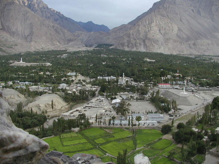
Skardu Town as seen from the Skardu Fort
In recent years, the highway has become a destination for adventure tourism. It was ranked as the 3rd best Tourist Destination in Pakistan by The Guardian.The road has given mountaineers and cyclists easier access to the many high mountains, glaciers and lakes in the area. The highway provides access to Gilgit and Skardu from Islamabad by road. These are the two major hubs for mountaineering expeditions in the Gilgit-Baltistan region of Pakistan-administered Kashmir.
The Gilgit-Baltistan Administration of Pakistan and the Xinjiang Administration of China have signed an agreement to issue border passes to their permanent residents. This pass is valid for a calendar year and is used to travel through Khunjerab Pass only.
The Gilgit-Baltistan Administration of Pakistan and the Xinjiang Administration of China have signed an agreement to issue border passes to their permanent residents. This pass is valid for a calendar year and is used to travel through Khunjerab Pass only.
